June by the Numbers

I rode 1,625.5 miles this month for an average of 54.2 miles per day. This is much less than last year (2,260.5 miles).

I don’t keep track of elevation gain but I’m sure that I climbed much, much more than any other month in my life.

For the year I’ve ridden 5,556.5 miles.

The Mule is tired. So am I.

No Name Tour: Day 46 – Out of Desolation

My decision to stay in Cold Springs yesterday turned out to be a good one. Had I continued I might have ridden over 100 miles. It would have been the end of me.

I ate dinner at the store/bar/restaurant in Cold Springs last night. They make one serious mushroom and Swiss burger. I hung out and talked with the regulars. Despite our political differences, we got along like old pals. The conversation was much better than watching TV in my room.

The restaurant didn’t re-open until 8 a.m., which is too late for bike tourists trying to make miles before the winds picked up. So I had two tortillas for an in-room “meal”. One with peanut butter, the other with bean dip. This would hold me until real breakfast 14 miles away at Middlegate Station.

It was a good decision. The road slopes downward and a light breeze helped me along. I made Middlegate in well under an hour. Along the way I passed the sites of telegraph, stage coach, and Pony Express stations as well as ghost mining towns. No ruins were evident just signs telling the story of what once was.

Middlegate Station itself is an old Pony Express and stage coach outpost. It looks it. It’s a bunch of run down buildings and cabins surrounded by RVs. As I said, I’m glad I stayed in Cold Springs.

The main building had a bar/restaurant and the cook made a decent breakfast. Coffee was self service. My only problem was that it took an hour. When I went back outside, the wind had changed direction and picked up. For the next 45 miles I’d be dealing with 10 mph head and cross winds.

After Middlegate came two 4,000+ foot summits which confirmed that the two 7,000+ footers near Austin were the last of the big ranges in my ride across the Great Basin.

The valleys between the ridges were much sandier and saltier than anything I’d seen so far.

After the second summit I rode past Sand Mountain. It was created by the wind blowing sand across the valley. I could hear motors revving in the distance; it’s a very popular place for ATV riders.

About 45 miles into the day I became very tired and bored. Even with the salt flats and the humongous sand dune I’d had enough of these wide, windy valleys. I had no appetite. I didn’t stop to eat which is a big mistake.

I felt like I was in a stationary bike just grinding away and going nowhere. When the road turned toward the north I caught a tailwind. Seeing double digits in my speedometer lifted my mood for a few minutes but all I could think of was the convenience store five miles from Fallon, my destination for today.

The closer I got to Fallon the more traffic there was. And it included drivers who didn’t much care how close they were when they passed me. At one point, an oncoming car passed the car in front of it at about 80 miles per hour. My head was down from all the grinding away. When the passer went by me it scared the crap out of me.

Time to get off this road! I pushed my speed up to 15 mph and looked for the convenience store five miles before Fallon.

When I dismounted I realized it was quite hot outside. Inside there was Gatorade and a Klondike bar. As soon as I downed them I felt much better.

In the last five miles I saw creeks and irrigation ditches and small farms and green that wasn’t sagebrush. When I saw a CVS store I knew I was back in civilization.

It’s been weeks since I’ve seen fast food and pharmacies and, would you believe, a Safeway.

I took a brief tour of historic Fallon. Sadly it looked like it’s better days are passed. The biggest building in town is a Nugget casino.

I checked into a Super 8. The lobby is a casino. But bed and breakfast for under $70 suits me just fine. (I learned from the desk clerk that I can go online and get at least one free night now.)

I checked in and showered. I could see in the bathroom mirror that my time crossing Utah and Nevada had stripped at least ten pounds off my frame. I had dinner at Subway and hit a gas station convenience store for junk food.

Tomorrow is another 63 mile day with minimal climbing as I ride to Carson City, the state capital. I will be staying with a Warmshowers host. I also need to visit a bike shop to get some new brake pads.

On Tuesday I need to decide where I’m going. Do I push on for 2 1/2 weeks through the Sierras and Cascades to Portland or do I head west over the Sierras and finish this adventure in San Francisco?

Either way getting home is a logistical puzzle because of a lack of nonstop flights. (I actually looked into taking a train back to Pittsburgh and riding home from there but it’s crazy expensive and would take 2 1/2 days!)

Total miles: 63.5

Tour miles: 2,648

Top speed: 25.7 mph

More pix on Instagram

No Name Tour: Day 45 – Short and Lucky

Breakfast in Austin was the usual diner fare. It took a while to get my act together.

I hit the road a little after 7:30 and down I rode. No wind or perhaps a light tailwind made the going easy. About five miles into the day I spotted 11 antelope crossing the road. As I approached, five of them did a 180. I held my breath hoping the rest wouldn’t follow. They didn’t.

Into the Reese River Valley, then over 6,670 Mount Airy Summit. The climb was so gradual that I took it with my middle chainring.

Down into Smith Creek Valley then up again over 6,348 New Pass Summit. Once again the climb was gradual and easy.

The descent was as gradual as the climb. I stopped to check out ruins of an old stage coach station.

My route now coincided with the Pony Express, the Overland Stage Company, and the transcontinental telegraph line.

Off and on for the last few days, I’ve encountered big, hopping bugs all over the road. Tens of thousands of them. They looked like camel crickets. They seemed to be mating. Some of them were eating the remains of their dead comrades. I tried to avoid them but CRUNCH, CRUNCH, CRUNCH. Gross!!!!

Just before noon, at exactly 50 miles, I stopped at Cold Springs Station. It has a bar, restaurant, convenience store, RV Park, and motel. I took a seat at the bar next to an eastbound bicycle tourist. He advised me that a motorcycle event had booked all the rooms at my planned stop 13 miles west in Middlegate.

My choice was to ride 60 more miles to Fallon or crash in Cold Springs. I decided to take the path of least resistance and stay in Cold Springs.

Mikes today: 50

Tour miles: 2,584.5

Top spreed: 33.5

No Name Tour: Day 44 – Taken

Last night’s dinner of a hot roast beef sandwich with mashed potatoes, broccoli, and a side salad was augmented by a large beer. Large in the sense of could barely lift the mug.

I sloshed back to the surprisingly nice hotel where I watched the second Democratic debate for about 30 seconds. That’s all I could take of Eric Swalwell.

After a starchy hotel breakfast (Nevada does not do fruit), I rode up a small hill out of town. For the next 28 miles I was cruising at speeds in the high teens. Through Devils Gate and Yahoo Canyon into a basin for 28 glorious miles. Then I was punched in the face by a wind gust.

Uh oh, here it comes. The next five miles were like sparring with an invisible opponent. Then the wind became constant. Once again I was grinding away at low speed. So frustrating.

I climbed over 6,556 Hickison summit before riding into another wind in my face basin.

58 miles in, I turned north and up . Climbing, even with a tailwind wasn’t happening. There were stops and there wS walking.

I arrived at Bob Scott Summit and found no sign. Bite me, Nevada. I biked and, mostly walked, all this way. I want a damned sign.

Down the back side I rode, accelerating through 30 mph. A pickup truck surprised me as it passed uncomfortably close. My mouth opened and a large black bug landed on my upper lip. And sting me. So here I am, riding down a ridge at over 30 mph with a pick up truck just off my left elbow and I getting stung by an unknown creature that nearly got into my mouth.

This could ruin your whole day. Trust me.

I survived the ordeal and rather enjoyed the descent once the pain subsided. Then the road turned upwards again. And steeply. With dead legs, a gallon of water and over 30 pounds of assorted crap on my bike I had to make a choice: destroy my knees or walk.

No brainer.

After a half hour of pushing The Mule I saw the sign for Austin Summit, 7,484 feet. The last three miles were a steep, curvy descent to Austin, another town like Eureka. A few businesses, several dilapidated old storefronts, a couple of bars, a cafe, and a few hotels.

I stopped at the cafe and, on a whim, checked my rims. They were hot from all the braking I did on the descent

At the cafe, I had a proper lunch because nothing I ate during the day proved adequate.

Austin is on a hill so I rode down in search of a hotel that had decent WiFi. I needed to Facetime with my wife to fix the WiFi at home. The Cozy Mountain hotel had a room and rural Nevada WiFi.

After discussing behavioral economics with the motel owner (I turned her on to Dan Ariety and we discussed Nudge, Thinking Fast and Slow, a few Michael Lewis books, and Thomas Piketty, I checked in and did the call with my wife. (I didn’t fix the problem. Bike riding economists aren’t very useful.)

I went out to dinner and had undercooked pizza and beer that was over 20 months past its sell date. Haute cuisine in small town Nevada.

In three days I should be in Carson City where I get to make a decision: continue on to Portland via the Sierras or ride across the mountains to Sacramento.

Some of you may have heard that I was served a subpoena to appear in court in a civil matter in mid-July. I learned today that the case has been delayed so the tour can go on on its own merits. (It’s a personal injury lawsuit involving two cyclists injured by a security gate on the Mount Vernon Trail.)

Tomorrow, MOTS, more of the same.

Miles today: 70

Tour miles: 2,534.5

Top speed: 33.3 mph

No Name Tour: Day 43 – Rest Is Good

After a day off and switching to a much nicer hotel, my body and brain had recovered from some seriously hard days of riding. In Nevada, if the miles and hills don’t get you, the wind will.

Breakfast was provided courtesy of the Denny’s in the hotel. I hit the road at 6:45 and was allowed passage through the work zone on the edge of town.

The road wound it’s way through some seriously high mountains with barely an incline. Just outside of town, at the top of one of the mountains, I could see evidence of a massive copper mine.

A cool tailwind pushed me over Robinson Pass at 7,607 feet. The descent was encumbered by a blustery side wind, the result of the road turning from the north to the south and west. It battered me as I crossed a basin and wended my way into the Butte Mountains.

Being a good little road, it turned to the northwest affording me s tailwind over Little Antelope Summit at 7,438 feet.

The road nudged to the west but the crosswind through the next basin was bearable. Up and over 6,517-foot Pancake Summit then down into the Newark Valley, with an increasingly strong side wind that occasionally blasted me in the face.

Next up was 6,433 Southgate, an unmarked summit they preceded a turn of the road to the north.

Tailwind ablowin’ I rode 5-ish miles to 7,376, mostly in my middle ring. To be honest, I was knackered at this point, stopping to reload my water bottles and munch snacks.

Once I was over the top the fun began. A downhill with a tailwind is a mighty fine thing. I was over 40 mph in no time, feathering my brakes to avoid disaster.

I smiled, slightly terrified, all the way to Eureka, my stop for the night.

Before grabbing a hotel room I stopped to talk with Giovanni and Cristina, tandem riders from the northwest of Italy. They were struggling with a broken tent pole that they managed to repair as we talked. They are participating in a cross country bike race. Their legs had some nasty cuts and scabs from mishaps along the way but were a blast to talk with.

Another, solo rider from the race stopped by. His name is Indiana. He chatted for a few minutes then took off on his bike packing machine bound for Battle Mountain.

Eureka is an old western town with a few businesses making a go of it. My hotel is mighty nice, a surprise after hearing unflattering things about the town from a rider who is a few days ahead of me.

Tomorrow is a repeat with few climbs until the last six miles heading over into my destination, Austin, Nevada. Back to back 7,000 footers. Oof.

Miles today: 77.5

Tour miles: 2,464.5

Top speed: 44.4 mph

No Name Tour: Day 42 – Rest Day in Ely

I made the right choice to take today off despite really nice weather. I expected Nevada to be broiling hot but it’s a pleasant 76 degrees albeit with strong winds.

Here’s how I’m resting:

  • Sleep nine hours
  • Walk to Mickey D’s (closest place) for breakfast
  • Stop at grocery store for provisions for tomorrow
  • Check out of the Motel 6 and roll down the hill to downtown Ely.
  • Roll through downtown at walking pace
  • Talk with flag person about the road closure situation on my route for tomorrow. (No worries. I can bike through.)
  • Stop at coffee shop for a cuppa and an excellent, buttery blueberry scone
  • Kill an hour talking to the young woman behind the counter
  • Learn that the big employers around here are mines (copper) and a maximum security state prison
  • Go to sporting good stores to use their floor pump. Browse for ten minutes. The place sells beaucoup guns. Depressing.
  • Roll back to a park with trees and shade and hang out.
  • Grab lunch (tomato bisque and a massive grilled cheese sandwich)
  • Go to Hotel Nevada where I learn that my room comes with tickets for two free beers and breakfast.
  • I’m hanging in the lobby in a massive leather comfy chair waiting for my room to be ready.
  • Tonight I’ll use my drink tix and have dinner. I might watch the debates if I get bored.
  • I hope to hit the road before 7:30 tomorrow. It’ll be a long day. 78 miles. Four summits. Lots of wind.
  • Miles today: 4
  • Tour miles: 2,387
  • Top speed: 22.4 (gliding downhill)
  • No Name Tour: Day 41 – Easy Day Turned Hard

    Today’s ride from Baker to Ely was supposed to be relatively easy: 62 miles and two mountain summits (both over 7,000 feet).

    I ate dinner and breakfast at Kerouac’s one of two restaurants in town. It had a limited menu for both meals, cold beer (at dinner) and a very cool atmosphere (background music included lots of mellow tunes including one by XTC that I’d never heard). Pricey? Yes. But a pretty good find in a dusty town with a population of 68 people.

    The motel I stayed at was in an RV park. It looked rather run down but it served its purpose. I slept for ten straight hours.

    After breakfast I headed down the road for about five miles. It seemed downhill which is a nice way to start the day. Nicer still I had a bit of a tailwind and some nonthreatening cloud provided relief from the sun.

    The Mule turned 54 today.

    Although I started at 8:15, it’s a bit late owing to the fact that I’m now on Pacific time. Winds tend to be lighter early in the morning which might have been a factor a few hours into the day.

    I picked up US 50 (yes, the same one!). Out here it’s called the Loneliest Road in America. It seemed mighty busy to me.

    I was feeling pretty good, especially after yesterday’s long ride. I knew it had to be a tailwind. I rode all the way up to Sacramento Pass at 7,154 feet. I never felt stressed during the climb, stopping only to munch and eat.

    Over the top the thrilling descent revealed the strength of the winds. I was flying down the mountain and getting blown all over. Thankfully, no cars or trucks or rental RVs passed me.

    The descent turned toward the south as I entered Spring Valley in the shadow of Windy Peak.

    That beneficial tailwind was now in my face and it was strong. (Should’ve hit the road earlier!) even with the remains of the downhill I had to work my butt off to make forward progress. In the valley there were lines of wind turbines spinning away.

    The road included a short incline that would have been unremarkable except for the hand of the wind god on my chest.

    The wind only intensified, somewhat unusual for this time of year, I’m told.

    Crossing the valley to the nearly nonexistent town of Majors Junction took over three hours. The valleys are supposed to be the easy part!

    I stopped at an RV Park/Bar/restaurant/motel. The property was surrounded by a fence topped with antlers. The neon sign said “Open”. There was no sign of customers or operators. A sign on the locked door said, “Out back in the barn. Back in 5 minutes.” The porch of the place provided shade from the hot sun while I waited. And waited.

    This sign was mocking me.

    After 15 minutes a woman came out and said, “We’re closed. Tuesday is my only day off.” In other words, “Get lost.”

    So I headed up the ridge on the western side of the mountain. My battle with the winds in the valley had deadened my legs. Thankfully the route turned back to the north giving me a helping wind that I sorely needed.

    It was only five miles to the top but it took well over and hour. I kept stopping to rest and re-full my water bottles from my bladders. The wind was blowing so hard that I was having trouble transferring the water.

    I kept poking along until I reached Connors Pass at 7,722 feet. I was a hurtin unit.

    With that wind at my back and a long downhill to the Steptoe Valley I moved from my granny to my big ring and boogied. 22 miles to go. Nearly out of water. (Or so I thought. I had at least a liter left.)

    One surprise today was how green the valleys are. Snow continues to melt on the ridges. I was hoping for flowers but I’ll take grass and sagebrush and trees (on the hillsides).

    I closer I was to Ely the slower I seemed to go. I was obviously running out of gas. I grabbed the first cheap hotel I could find, a Motel 6. It’s not nearly as nice as the cheap motels I stayed in the last three nights. (The swimming pool outside my door is gross.)

    While sitting on the porch of the closed place in Majors Junction, I decided that if I was having this much trouble on an easy day, I’d be screwed on a longer day. My next day is Ely to Eureka. 78 miles. Four summits. No services. Similar weather.

    So I am taking a rest day in Ely. I haven’t had one since Salida, Colorado over two weeks ago. This will give me a chance to rest and buy food. I’m also changing to a different hotel in town.

    Miles today: 61.5

    Tour miles: 2,383

    Top speed: 35.2 mph

    No Name Tour: Day 40 – 3 Summits, 2 Dust Devils, and 1 New State

    Today’s ominous warning from the Adventure Cycling maps I’m using: No services for 84 miles. BYOEverything!

    After diner breakfast I headed out. I planned to start earlier but it was too cold out. Wimp.

    The ride was gradually uphill out of Milford for ten miles before riding up over Frisco Summit at 6,723 feet. It’s just west of the abandoned (and apparently obliterated) mining town of Frisco.

    The 13-mile climb was rewarded with a 12-mile (maybe longer) descent into the huge Wah Wah Valley. Every George Harrison fan should ride here. It’s wide open ranch land as far as I could tell. In fact, all across Utah I’ve seen signs for Open Range but until today haven’t seen many bovines. The roads have cattle guards which are perfectly safe to ride over (at a right angle). It’s a bit unnerving to cross one at 30 mph but I’m still here so no worries.

    Today for the first time I saw cows next to the road. One giantess seemed to want a word with me. No thanks, bossy. Please don’t approach.

    One aspect of these valleys is that it’s almost impossible to tell distances or slopes. I was cranking along for what seemed like hours and the other side of the valley was still out there. The other side of this valley included a deceptively long and increasingly steep climb.

    I am also in the land of dust devils, wee tornados of dust. I saw two today.

    I burned out spinning up the hill and decided to save my legs for the second half of the 84-mile day. I hoofed it to the summit. Near the top a motorcyclist stopped in the middle of the road and asked if I was okay. Sure, too much mountain, not enough legs.

    One of three

    With the Wah Wah Summit behind me I went flying down another miles long hill into another vast valley. Then I started the gradual then steep climb up the other side. Once again I ran out of legs and walked to Halfway Summit.

    This time the descent was more gradual. All day I’d been getting nailed by side winds. Toward the end of the day the turned into tailwinds. The temperature climbed into the mid 80s but the wind had a cooling effect. Did I mention that for the entire ride there was no shade whatsoever?

    After the blink and you’ll miss it town of Garrison I headed into Nevada! Oh joy.

    Eight miles of grinding later I was in a motel room at an RV park in Baker. It’s managed by the big brother of one of the diner staff back in Milford.

    Dinner tonight is at Kerouac’s, a surprisingly cool place in town. I could have eaten across the street at a less chic place but my friend Michelle is a huge Kerouac fan and she got married on Saturday, so it seemed fitting to eat here.

    They are open for breakfast so I’ll be back to fuel up before the 60-something mile ride to Ely. The ride features two summits over 7,000 feet. There will be walking.

    With the heat and lack of services I’m making good use of the two two-liter water bladders I brought. I was down to my last liter today.

    Miles today: 83

    Tour miles: 2,238.5

    Top speed: 30.4 mph

    No Name Tour: Day 39 – Nowhere to Go but Milford

    After yesterday’s big effort, I needed an easy day and Utah provided it.

    I’m finding that eating a substantial breakfast makes a big difference in how the day goes. Good thing diners were invented.

    Riding north out of Cedar City by 8:15 I was heading down for about 15 miles on a straight, two-lane road. Yesterday’s mountains were to my right. An unknown, much less impressive hill was to my right. A gentle wind nudged me along.

    Not going to any of these places
    Gonna be an awful lot of this in the days ahead
    Almost 4,000 feet below yesterday’s summit

    After cruising at 15-18 mph, I had to climb to a “summit” at 6,570 feet. A month ago this would have worried me and stressed my body. Today, I barely noticed the climb.

    Bike touring does that to you. At home I’d consider a 1,000+ foot climb and riding over 50 miles to be a tough day’s work. On s tour it’s called a rest day.

    The ride from the top to Minersville under clear skies and warm dry temperatures was marred only by a dude in a pickup truck who decided it would be amusing to lay on his horn as he passed me. All the way to town I thought how fitting it would be to key his shiny truck. Unfortunately I left my keys at home which raises the question, “Can you spork a truck?”

    If there was food to eat Minersville, I couldn’t find it. In the process of my search I missed a turn to stay on route. No worries. I found a very nice two-lane highway that took a more direct route to my destination, Milford, Utah.

    I was now headed west so the winds had little effect on my speed and effort. I passed through farmers’ fields and vast expanses of sage brush.

    In Milford I stopped to stock up on provisions for tomorrow then checked into the Travelodge on the western side of town. As I was told by east bound riders, the motel offers a steep discount for bike tourists. It’s s fine room for $45. I suppose they’ll make up the difference from my trips to the 24-hour diner on the property. One of the Hopkins riders told me that their mushroom Swiss burger was excellent. It was, especially followed by a root beer float.

    Lunch gave me the opportunity to do laundry. (I’d been sink washing my clothes for a week.) I ate wearing my rain jacket and pants. As Joe Walsh said, I was “washing everything I own except my shoes.”

    Tomorrow I leave Utah and enter Nevada, the land of whiskey, weed, and harlots. More germaine to the tour are some interesting new features to the route. First, the town’s from here to Carson City are spaced far apart. Each day will have at least one climb as I head west through basin and range country. And temperatures are rising into the 90s. High winds are forecast for the second half of this week.

    Tomorrow will feature 84 miles with no services and three climbs similar to today. I’m ready. I got 6 liters of water and all kinds of munchies (Clif Bars, Fig Newtons, trailmix, chewy granola bars, and bean dip (peanut butter is getting old) on The Mule.

    Miles today: 56.5

    Tour miles: 2,238.5

    Top speed: 27.7

    No Name Tour: Day 38 – Cold and Dizzy

    My decision to stay in a motel in Panguitch town turned out great. It was 35 degrees when I work up at 6. 18 miles further along the route. The overnight low was 28. Bullet dodged.

    After a diner breakfast I headed out, west and up. Panguitch is at 6,600 feet. The lake is at 8,200 feet. As I usually do, I struggled with finding a climbing rhythm at the start of the ride. I finally gave up after five or ten frustrating miles and started walking.

    It was cool and I had a light tailwind but my cycling legs wanted nothing to do with the hills.

    After about a half mile I tried again and immediately found a rhythm that I would keep but got a few rest stops until I approached 10,000 feet about 28 miles into the day.

    The skies were blue. The scenery wooded. The brooks babbling along the road side were filled with clear snow melt.

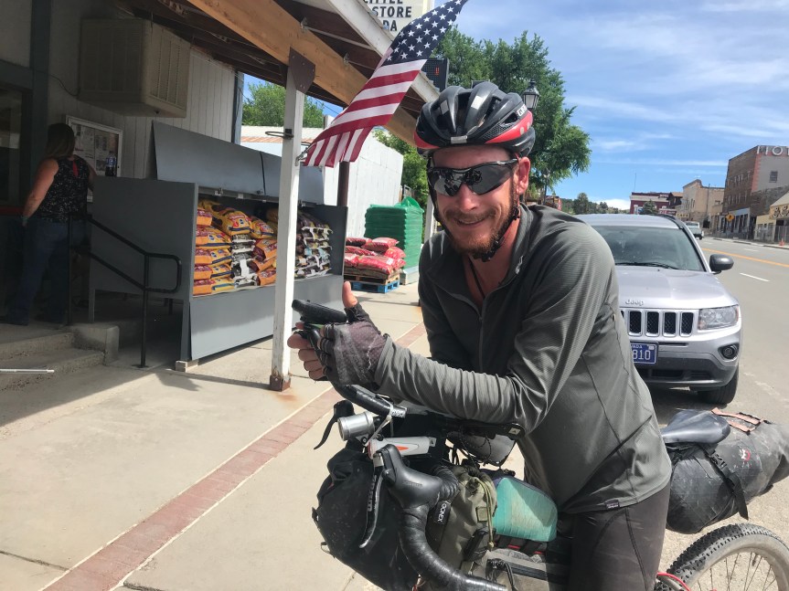
    When I got to the lake about 18 miles into the day, I stopped at a general store. When I dismounted I immediately felt a chill. All my climbing had made me oblivious to the fact that it was in the high 40s.

    Inside the store I drank a Gatorade and ate some Doritos next to a fireplace that was burning logs to bear the heat. Ahhh.

    All good things must end. I pulled on my jacket and long fingered gloves and began again. Up. Got miles and miles. I was spinning away in my easiest three gears, lucky to break 7 mph.

    I stopped only to snack. A pear that was hard two days ago was now juicy and ripe. Gone. Chewy granola bars were my next victims.

    I kept grinding away thinking that the 10,300 foot summit was many miles away. I got off my bike and looked at the compass and elevation app on my phone. It said I was at 9,600 feet. Then I jiggled my phone and the app recalculated. 10,000 feet. Could it be?

    There was snow in the shaded areas along the road. Maybe the app was right after all.

    With elevation comes other problems. I could tell I was dizzy. I knew I needed to get off this mountain soon.

    I made a turn to the south. The wind seemed to turn with me. The road was now gently rolling, but still trending upwards. As I came speeding down a curvy section the Mule felt like it was out of control. It was just irregularities in the pavement coupled with my light headedness. I gently applied the brakes and The Mule came back under control.

    Then I saw a massive snow pile next to the road. And shortly thereafter the Cedar Breaks National Monument visitors’ center.

    I pulled in and paid my $0. I asked a ranger if this was the summit. He said it was and that the rest of the ride would be a steep descent.

    It was very cold and windy so I didn’t linger at the viewpoint. All the way up I rode through forests and meadows. The Breaks is where this landscape abruptly becomes a red rock canyon again. When you’re already dizzy, looking at sheer cliffs they stop thousands of feet doesn’t help much.

    I left after five minutes. On the way out I checked out s couple of telescopes they were aimed at the sun. My eye was immediately burned to a crisp.

    Not really. The telescopes has filters that allowed you to see either the entire orange orb or the chromosphere, the red disk that sends off solar flares.

    I reloaded my water bottles using one of my 2-liter bladders and began to descend.

    Did I mention it was really cold and windy? For the rest of the ride, I froze my ass off. The price I pay for 20+ mile bicycle bobsledding. (Riding down this mountain on a faired long wheel base recumbent would be amazing.)

    The road was curvy and steep with scary drop offs to the side. I feathered my brakes to keep The Mule from killing us both. One road sign had an “S” on its side. It was a crazy switchback.

    As the road straightened I allowed the bike to break 30 mph. A right turn at a stop sign put me on the final 12 mile approach to Cedar City.

    All of it downhill.

    About a half mile later I saw touring bicyclists coming up the hill toward me. They were recent graduates of Johns Hopkins who were riding from San Francisco to DC. They were raising awareness in the rural communities hey were riding through about college opportunities in DC.

    Considering the fact that they had been climbing up a 16-mile monster hill, they were in incredibly good moods.

    After we parted I hopped back on The Mule and lost control. Fortunately I was only going 10 mph when I veered off the pavement onto the soft shoulder. I managed not to fall and brought the bike to a stop. Still dizzy, I guess.

    Back in the pavement I flew downhill for 16 glorious miles. I passed the base of the red rock cliffs of the Breaks and followed the two lane highway as it curved around incredible, massive, multicolored rock formations. I’d have taken some pictures but I was trying not to die.

    The road flattened out and there I was in Cedar City, a really City of over 28,000 people. The biggest city I’d been in since Pueblo, Colorado two weeks ago. And it’s at only 5,800 feet.

    Traffic. Traffic lights. Residential neighborhoods. Car dealerships. And, best of all, lots of cheap hotels. (Room to let $50.)

    After check in and cleaning up I walked to a diner for food and a celebratory vanilla shake.

    I am done with 10,000 foot. all-day climbs. And I am only one day behind schedule. Tomorrow I head north, my last day in Utah before tackling the Nevada desert.

    Ooh, what fun that will be.

    Miles today: 58.5

    Tour miles: 2,182

    Top speed: 35.1

    Lots more pix on my Instagram page.