Trails to home

Today was the first day since the before times that we allowed our bi-weekly cleaning service back into our house. This meant that my wife and I didn’t have to spend a good part of the day cleaning. It also meant that we needed to get out of the cleaners’ way. Normally, we would go to a diner then a library. With that off the table (or booth) my wife made me an offer I couldn’t refuse. “Why don’t we drive someplace, I’ll drop you off and you can ride your bike home?”

Sounds like a plan to me.

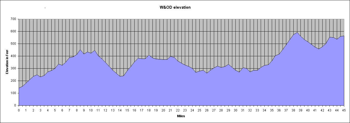
So we jumped in my dusty Accord and drove to Purcellville, Virginia at the base of the Blue Ridge Mountains. I would ride east 45 miles on the Washington and Old Dominion Trail back to Arlington. There I’d pick up the Four Mile Run Trail for a couple of miles before turning south on the Mount Vernon Trail.

With the pandemic still in evidence, the drive to the start was uneventful. I left my wife to check out the bakery at the trailhead. (Thumbs up on the eclairs, she reports.)

I expected the ride to be mostly downhill. It is. Purcellville is at 575 feet whereas the low point of the ride near National Airport is at 15 feet. Of course there are a few long grades both up and down along the way, as well as a few abrupt rollers to keep things interesting.

What I wasn’t counting on was the headwind. Having an invisible hand on my chest put a damper on my speed. I did do a few miles at 18 to 20 miles per hour but not as many as I had hoped.

The trails were not crowded at all, except for one group of eight old folks out for a meander. Old people suck. Oh, wait….

Anyway, a few minutes delay is not much to complain about.

I had two small energy bars left over from my 50-States Ride goodie bag. That’s all I ate. I was surprised that I didn’t bonk. I also drank two large water bottles. Maybe my modest intake is to blame for the cramps that came on during my post-ride stenosis physical therapy session.

Outside Purcellville I saw a momma and a young deer. They were too shy to be photographed. Later I saw a Dad with his daughter examining a box turtle that had inched onto the trail. My final critter of the day was a rather large groundhog that was standing at attention a foot off the trail in Vienna. It seemed not the least bit concerned about me as I rode past.

The trees are turning. I had hoped for more reds but today offered more browns and yellows. One big leaf decided to hitchhike on my front wheel causing a racket when it got stuck between my tire and fender.

I was sorely tempted by the breweries and brew pubs along the trail. There seems to be one every five miles or so. You could get a serious buzz on if you stopped at each one.

East of Vienna the trail is undergoing work. There’s a detour that I couldn’t quite figure out but once I got straightened away, I found it: a on-road protected cycletrack (two lanes, one in each direction). Well done. In Falls Church city, the trail is being doubled to accommodate traffic. (I wonder if people opposed the trail when it was being built, thinking nobody will use it. Can’t imagine what they’re thinking now.) The detour around the construction is on road and unprotected. There’s hardly any car traffic so no worries.

At the eastern end of the Falls Church construction is a new bridge that will take the trial over North Washington Street and do away with a dangerous at-grade crossing. It looks like the bridge is nearly done. It’ll be a huge improvement.

Back on the street near home, drivers weren’t allowing me to move over to make a left-hand turn. I kept riding straight and overshot my turn. Before doubling back I could see the line for early voting at the government center down the street. Yesterday the line extended nearly a half mile along the sidewalk. Today, it was considerably shorter but my wife says that’s because people were a bit more bunched together. These two days brought to mind the lines at the polling place on election day 2008 when the prospect of the first black president brought an incredible turnout.

It’s been a while since I did a point-to-point ride, the stuff of bike tours. DC-area trails are limited in coverage and connectivity but if you play your cards right you can ride 57 miles and do 54 1/2 of them without a big metal thing breathing down your neck. Not a bad way to avoid a cleaning crew if you ask me.

Minding the W&OD

“Everything is walking distance if you have the time.” Steven Wright

Q: “What’s the secret to a long marriage?”

A: “Don’t get divorced?” Olivia Harrison

After a rather ambitious week of riding (252 miles), I decided it was time to up my game. I had intended to ride the Whites Ferry Loop on Saturday but I got underway a bit late and decided to abandon the effort about 28 miles from home. The resulting 57-mile excursion left me wanting something more better.

And so I launched Big Nellie intending to ride the big beast to Purcellville. About 1/4 mile from home, its rear shifter cable snapped in two, so I returned home for The Mule. While changing out of my recumbent clothes (regular street clothes) into biking gear I had an asthma attack.

My asthma diagnosis is mild persistent asthma. It manifests itself not in wheezing episodes but in labored breathing and a fog of depression. One puff of a rescue inhaler (albuterol sulfate) and my lungs settled down. I hopped on The Mule ready to rumble.

The out-and-back route involves three miles on suburban streets to the Mount Vernon Trail. The trail takes me north along the Potomac River about six miles to the Four Mile Run Trail at National Airport. After another three miles the FMRT ends in Shirlington where I pick up the Washington and Old Dominion rail trail which goes 44 1/2 miles all the way to Purcellville at the base of the Blue Ridge Mountains.

I’ve probably done this ride ten times. It’s a good test of riding endurance and the ride (except for one hill on the way back about 2 1/2 miles from home) seems virtually flat. I said “seems” because ride gains elevation then gives it up, resulting in about 1,400 of gross elevation gain.

The scale of the chart is deceptive; each gain in elevation is gradual, but for a handful of abrupt rollers from time to time. The biggish hill from mile 32 to mile 39 is mostly uninterrupted. The one from mile 1 to mile 9 has several cross streets and traffic lights making it hard to take advantage of the favorable grade on the return.

Along the way the trail passes through Arlington, Falls Church, Dunn Loring, Vienna, Reston, Herndon, Sterling, Ashburn, Leesburg, Clarks Gap (the high point), Paeonian Springs, and Hamilton Station before ending in Purcellville.

It always seems like a long slog on the way out. Mostly I attribute this to the gradual elevation gain. There’s also a psychological element that I’ve never been able to get my head around. Going places somehow seems much longer than returning, regardless of your mode of transport.

The density of trail users fluctuated as I passed through more heavily populated areas. If you’re into beer, you can stop at several mircobrewies along the way. (I didn’t.) Many years ago the area near Dulles Airport was farmland but nowadays it’s suburban sprawl. From Ashburn to Leesburg is less developed. You can check out a quarry if rocks are your thing. From Leesburg to Purcellville is a tunnel of green bliss, easily my favorite part of the trail.

My odometer is rather sketchy but it read 56.36 miles when I reached Purcellville. I took a selfie with one of the Purcellville signs (the other had too many bikes under it so I had to go small.

Bikey mask courtesy of Mrs. Rootchopper

There’s an old saying among marathoners. The race is 26.2 miles long. The halfway point is around 20 miles. That’s when the bear jumps on your back.

I expected the same from this ride. I had about five hours of daylight left so I was definitely in Steven Wright mode. The way to ride over 100 miles is, like Olivia Harrison says, is to keep on going.

And there I was bombing down the long grade from Clarks Gap at 20 miles per hour. The downhill grade and the mental aspect of having already seen the sights put my mind at ease. I’ll get there when I get there.

On the way out I ate a bagel with peanut butter on it. At Purcellville I snarfed some trail mix. I stopped in Leesburg on the return for more snacks. A gatorade and some cookies got my energy back up.

The gentle rise in the trail just west of Vienna started to mess with my head. It’s a false flat; it looks level but it’s not. When I finished with it, I stopped at the Vienna railroad station (long ago made inactive) and ate a Snickers bar.

23 miles to go. No guts, no glory.

As I plowed along, body parts started to complain. My thighs. My lower back. My left shoulder. To ease my discomfort, I stretched as I rode. I got out of the saddle for the short climbs, anything to distribute the fatigue. (Sadly, you can’t do this in marathons. You’re body goes all wonky and you just have to run through it which is rather depressing when you can’t lift your thighs.)

Three miles from home I decided to climb a short steep hill to avoid adding a bit of distance to the trip. It was the only time I used my granny gear. My knees were thankful.

20 minutes before sunset, I rolled into my yard. 113 miles, my longest ride since June 2018, and only my third century since then.

Anything is biking distance if you have the time and don’t quit.