White’s Ferry Loop

One of the long rides I try to do every year is the White’s Ferry Loop. This ride links up several trails in the DC are for a 90-mile circuit. Including the 9 1/2 miles to the loop from my house brings the total mileage to 99. Typically, I add a mile somewhere along the way for the full century.

I chose to ride clockwise because the forecast called for heat and humidity. This would put me on the shaded C&O Canal towpath for the hottest part of the day.

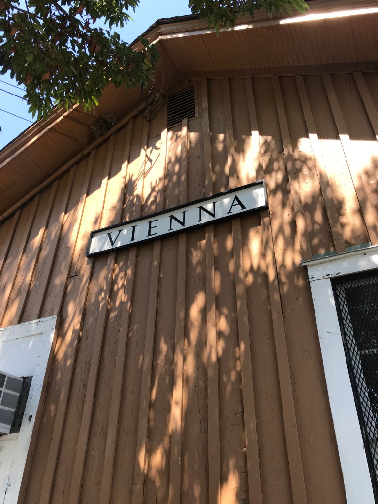
I boogied along for 23 miles taking streets and two trails (see below) before stopping at the Vienna train station building to refill a water bottle. Then I was back on the W&OD Trail all the way to Leesburg, about 47 miles from home. Whenever I could I topped off my water botlles. To be on the safe side, I carried five bottles, two on the bike and three in a pannier. I also brought snacks. Peanut butter on bread, pretzel sticks, and a couple of old chewy granola bars.

I rode on King Street through Leesburg, which had many tempting places to eat. In fact, if you stopped at every microbrewery along the way you’d pass out before the ferry.

North of Leesburg is the sketchy connection to US 15, a busy north south highway. I lucked out as there were no cars coming. The highway has a big shoulder along this part (because bicyclists were hit and killed several times in years gone by).

After a half mile , I turned onto Whites Ferry Road for another 1/2 mile of quiet country road to the ferry. If cars are coming toward you, you can take your time, because the ferry is crossing back to Maryland. I arrived at the ferry and waited in the shade for the trip back. As ferry trips go, this one is pretty calm. It only takes five minutes.

The store on the Virginia side is up an embankment. The exterior of the building has marks with dates next to them showing the high water marks for major flood events. Suffice it to say, Hurricane Agnes did a number on this river valley back in the early 70s.

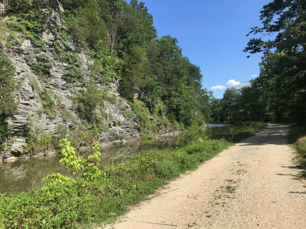
After some ice cream, Gatorade, and a port-a-potty break I headed south on the C&O Canal towpath. The double track of the past is gone, replaced with an unpaved smooth surface. For five miles, that is, until it’s back to the bumps. Riding a recumbent means you feel every bump because you cannot easily lift your butt off the seat.

Near Seneca Creek the towpath is muddy. I was slipping and sliding but I didn’t fall.

From time to time, I saw deer, squirrels, herons, and large ominous looking birds. Mostly I was just trucking along and enjoying the shade. I particular like the sections where you can see the river with all the large rocks randomly poking above the water line and the places where the canal is filled with water and bordered by ominous rock walls.

After 32 miles I switched back to pavement on the Capitol Crescent Trail. This brought welcome relief to my back. The bumpy towpath was messing with my stenosis and I was constantly dealing with achy feet and an achy butt.

The CCT leads to the nifty Water Street cycletrack which connects to a side path that runs past the Watergate and the Kennedy Center along the Potomac River. After passing the Lincoln Memorial I switched over to Ohio Drive, which is the epicenter of the Cherry Blossom Festival in the spring.

At the Jefferson Memorial, I crossed over the river on the 14th Street Bridge which connects to the Mount Vernon Trail and the 12-mile ride home.

All aboard!
Waiting for the ferry
Imagine water well above the treetops. It happens every so often
The White’s Ferry Store serves food and sells snacks.
Groomed towpath is a big improvement
Rocks in the river
Cliffs, canal, towpath
Little Falls Dam northwest of DC

Here’s a cue sheet. Most people just do the loop starting and ending at Step 3.

  1. Three Miles of suburban streets to the Mount Vernon Trail
  2. Mount Vernon Trail north 6 1/2 miles through Old Town Alexandria to Four Mile Run Trail.
  3. Four Mile Run Trail west 3 miles to the W&OD Trail
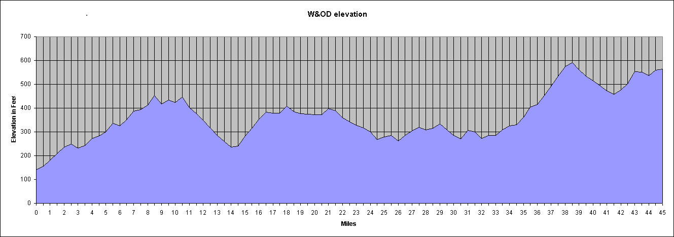
  4. W&OD Trail 35 miles to South King Street in Leesburg
  5. Right on South King to US 15 north of town, about 3 miles
  6. US 15 to a right on Whites Ferry Road, 1/2 mile
  7. White’s Ferry Road 1/2 mile to the ferry
  8. Ferry across Potomac ($2)
  9. Go 100 yards up the hill on the Virginia side
  10. Take a right on the C&O Canal towpath and ride 32 miles to Thompson’s Boat House
  11. Switch to paved Capital Crescent Trail and Water Street in Georgetown for 3 miles
  12. Right onto Rock Creek and Potomac Parkway path to Ohio Drive (1 mile)
  13. Ohio Drive to 14th Street Bridge (1/2 mile)
  14. Cross bridge to Mount Vernon Trail (1/2 mile)
  15. Take a right on the trail. Go 9 miles.
  16. Re-trace suburban streets home. 3 miles.

Finally, if you do this ride, bring water and snacks. There are pumps along the towpath but these may be turned off. Also, the National Park Service treats the water with iodine. The store at White’s Ferry has limited hours so I assume it’s closed. On this day it was open.

Minding the W&OD

“Everything is walking distance if you have the time.” Steven Wright

Q: “What’s the secret to a long marriage?”

A: “Don’t get divorced?” Olivia Harrison

After a rather ambitious week of riding (252 miles), I decided it was time to up my game. I had intended to ride the Whites Ferry Loop on Saturday but I got underway a bit late and decided to abandon the effort about 28 miles from home. The resulting 57-mile excursion left me wanting something more better.

And so I launched Big Nellie intending to ride the big beast to Purcellville. About 1/4 mile from home, its rear shifter cable snapped in two, so I returned home for The Mule. While changing out of my recumbent clothes (regular street clothes) into biking gear I had an asthma attack.

My asthma diagnosis is mild persistent asthma. It manifests itself not in wheezing episodes but in labored breathing and a fog of depression. One puff of a rescue inhaler (albuterol sulfate) and my lungs settled down. I hopped on The Mule ready to rumble.

The out-and-back route involves three miles on suburban streets to the Mount Vernon Trail. The trail takes me north along the Potomac River about six miles to the Four Mile Run Trail at National Airport. After another three miles the FMRT ends in Shirlington where I pick up the Washington and Old Dominion rail trail which goes 44 1/2 miles all the way to Purcellville at the base of the Blue Ridge Mountains.

I’ve probably done this ride ten times. It’s a good test of riding endurance and the ride (except for one hill on the way back about 2 1/2 miles from home) seems virtually flat. I said “seems” because ride gains elevation then gives it up, resulting in about 1,400 of gross elevation gain.

The scale of the chart is deceptive; each gain in elevation is gradual, but for a handful of abrupt rollers from time to time. The biggish hill from mile 32 to mile 39 is mostly uninterrupted. The one from mile 1 to mile 9 has several cross streets and traffic lights making it hard to take advantage of the favorable grade on the return.

Along the way the trail passes through Arlington, Falls Church, Dunn Loring, Vienna, Reston, Herndon, Sterling, Ashburn, Leesburg, Clarks Gap (the high point), Paeonian Springs, and Hamilton Station before ending in Purcellville.

It always seems like a long slog on the way out. Mostly I attribute this to the gradual elevation gain. There’s also a psychological element that I’ve never been able to get my head around. Going places somehow seems much longer than returning, regardless of your mode of transport.

The density of trail users fluctuated as I passed through more heavily populated areas. If you’re into beer, you can stop at several mircobrewies along the way. (I didn’t.) Many years ago the area near Dulles Airport was farmland but nowadays it’s suburban sprawl. From Ashburn to Leesburg is less developed. You can check out a quarry if rocks are your thing. From Leesburg to Purcellville is a tunnel of green bliss, easily my favorite part of the trail.

My odometer is rather sketchy but it read 56.36 miles when I reached Purcellville. I took a selfie with one of the Purcellville signs (the other had too many bikes under it so I had to go small.

Bikey mask courtesy of Mrs. Rootchopper

There’s an old saying among marathoners. The race is 26.2 miles long. The halfway point is around 20 miles. That’s when the bear jumps on your back.

I expected the same from this ride. I had about five hours of daylight left so I was definitely in Steven Wright mode. The way to ride over 100 miles is, like Olivia Harrison says, is to keep on going.

And there I was bombing down the long grade from Clarks Gap at 20 miles per hour. The downhill grade and the mental aspect of having already seen the sights put my mind at ease. I’ll get there when I get there.

On the way out I ate a bagel with peanut butter on it. At Purcellville I snarfed some trail mix. I stopped in Leesburg on the return for more snacks. A gatorade and some cookies got my energy back up.

The gentle rise in the trail just west of Vienna started to mess with my head. It’s a false flat; it looks level but it’s not. When I finished with it, I stopped at the Vienna railroad station (long ago made inactive) and ate a Snickers bar.

23 miles to go. No guts, no glory.

As I plowed along, body parts started to complain. My thighs. My lower back. My left shoulder. To ease my discomfort, I stretched as I rode. I got out of the saddle for the short climbs, anything to distribute the fatigue. (Sadly, you can’t do this in marathons. You’re body goes all wonky and you just have to run through it which is rather depressing when you can’t lift your thighs.)

Three miles from home I decided to climb a short steep hill to avoid adding a bit of distance to the trip. It was the only time I used my granny gear. My knees were thankful.

20 minutes before sunset, I rolled into my yard. 113 miles, my longest ride since June 2018, and only my third century since then.

Anything is biking distance if you have the time and don’t quit.