Tour Options for 2024

It’s starting to warm up and my thoughts are turning to a spring/summer bike tour. I have pared my ideas down to two tours, all originating from home and involving parts of the Atlantic Coast, Trans America, and Great Rivers South routes designed by the Adventure Cycling Association.

Pre-tour Jitters

I have some trepidation about this tour. Of course, pre-tour worry and anxiety is nothing new. It is tempting to let these feelings snowball, what Buddhists call papaƱca. There is some usefulness to anticipating problems, of course, but, left unchecked, this sort of mental proliferation can ruin your tour. About 50 miles into my 760-mile DC-to-Indiana tour, I was making myself miserable with pointless worrying. I stopped and gave myself a mental dressing down: “You’re on vacation. Relax. If bad things happen, you’ll figure them out.” It worked.

My list of worries is short. For a start, I am not a kid anymore. I was a youngster when I rode across the US alone in 2018 at the age of 62. I’m now 68 and don’t I know it. I have nagging physical issues with my lumbar and cervical spine. Also, I have the usual age-related reduction in muscle strength. The only cure for these things is to walk when I need to and to shorten my riding days to the extent practicable.

A second concern is dogs. The route I am taking is notorious for aggressive dogs. In the past I brought a small can of pepper spray. I never once used it gave me peace of mind. It occurs to me that on a windy day or on a downhill I am likely to spray myself. Yeah, let’s do 25 miles per hour downhill on a bumpy road with a snarling junk yard dog at my heels and get a load of pepper spray in my face. Nope. I am going to find a small horn of some sort and hope for the best.

Weather is always a concern. Since I am heading south, I am sure to encounter much more heat and humidity than last year. I’ll need to stay hydrated and take breaks. Depending on which route I take I’ll could be dealing with serious headwinds.

The topography is a bit intimidating. Like last summer, I’ll be crossing the Appalachian Mountains for a good chunk of the tour. In my mind’s eye this means steep climbs straight up one mountain after the next. That’s not how it works, of course, and I never seem to remember that those climbs are followed by descents.

Now, let’s consider the options.

Option 1: Finish the Trans Am

I have about left over 1,000 miles of the TransAmerica route unfinished: from Ashland, Virginia (just north of Richmond) to Ash Grove, Missouri (just east of the Kansas border). I’d ride south about 110 miles to Ashland then bang a right on the TransAm. And follow it over 1,400 miles to Ash Grove.

The eastern third of the TransAm Route

A big advantage of this part of the route is the lodging situation. There are something like 21 inexpensive places to stay including campgrounds, town parks, fire houses, hostels, churches, and such. Another advantage is the fact that I will encounter bike tourists along the way thanks to the popularity of the TransAm.

After Ash Grove it makes sense to me, at least, to ride south to Bentonville, Arkansas. This would take about two days and add 110 miles. There’s all kinds of flights to DC from this city thanks to the fact that it is the home of Wal-Mart.

Beyond Bentonville is the possibility of picking off Oklahoma. Tulsa is three days and 130 miles west. Add another 150 miles on old Route 66 and I’d be in Oklahoma City, another city with several flights to DC. All told, DC to Oklahoma City would make for a tour of about 2,000 miles. Tulsa and Oklahoma City have the added benefit of being on Southwest Airlines’ network, meaning I’d probably fly home for free.

Continuing on to Oklahoma City

Option 2: Laissez Les Bon Tons Roulez

This town is identical to the tour above until Marion, Kentucky just south of Cave-in-Rock. At Marion, I would pick up Adventure Cycling’s Great Rivers South Route, taking that to the start of the Natchez Trace near Nashville. With the exception of a detour to Muscle Shoals, Alabama to take in a bit of music history, I’d ride to Natchez, Mississippi. After that, it’s a few days of riding to New Orleans. The total mileage is about 2,100. Theoretically, I could take a train home from New Orleans but it would take at least 26 hours.

DC to Nola

I once had a business trip to Louisiana in April and could not believe how humid it was. Add ten or 15 degrees and you get pure misery. It probably would make more sense to just fly to Nashville, do the ride to New Orleans, and fly home. That would be about 900 miles and would take me about a month.

Bike Tour Planning – The Solo Route

The tour is in two parts. The solo part goes from Saint Louis, Missouri to Colorado Springs, Colorado. The team route goes from Colorado Springs to the Oregon Coast following the Adventure Cycling TransAmerica Route.

For the solo part of the tour, I decided to ditch Nebraska, Arkansas, and Oklahoma. The plan is to do the Katy Trail from O’Fallon, MO to Clinton, MO. Then take a couple of days to get to the TransAmerica Route at Ash Grove, MO. I’ll take the TransAm west to Hutchison, KS. Next I leave the TransAm to check out the Gyp Hills Scenic route between Medicine Lodge and Clearwater. I will angle back to the TransAm at Scott City then head west to Pueblo CO. From Pueblo it’s one day north and about 3,000 feet up to Colorado Springs. The dates below assume I don’t take any days off but I will almost certainly take at least two. Ash Grove is a free, indoor place to stay. There are any number of small towns on the TransAm west of Scott City that have free camping or indoor accommodations.

It’s pretty common for small towns in the plains, especially those on the TransAm, to have free camping for bike tourists in city parks. Hutchinson, KS and Sheridan Lake (not show, but it’s near Eads) in eastern CO have free indoor camping at churches. I am not anticipating using Warmshowers (a community of people who host bike tourists for free) because of Covid concerns.

DayDateStartEndMilesCumulative MilesSleep?
1May 22, 2022O’Fallon, MOMcKittrick6060B&B/City Park Camp/Motels
2May 23, 2022McKittrickHartsberg66126B&B/City Park Camp/Motels
3May 24, 2022HartsbergPilot Grove53179Town park camping/ B&B
4May 25, 2022Pilot GroveClinton63242Hotel/Camping Sparrowfoot
5May 26, 2022ClintonStockton55297Hotel/Camping Crabtree Cove
6May 27, 2022StocktonAsh Grove40337City Park Camp
7May 28, 2022Ash GrovePittsburg KS72409Hotel/camping
8May 29, 2022Pittsburg KSChanute60469Motels/City campground
9May 30, 2022ChanuteEureka62531Motels/City campground
10May 31, 2022EurekaNewton72603Motels/City campground
11June 1, 2022NewtonHutchinson47650Church Camping/motels
12June 2, 2022HutchinsonPratt56706Motels/Camping
13June 3, 2022PrattMedicine Lodge30736Motel/Camping?
14June 4, 2022Medicine LodgeGreensburg67803Motels/Camping?
15June 5, 2022GreensburgCimarron65868Motel/Camping?
16June 6, 2022CimarronScott CIty70938City Park. Motel. Hostel
17June 7, 2022Scott CItyTribune47985City Park
18June 8, 2022TribuneEads, CO581043City Park/Motel
19June 9, 2022Eads, COOrdway651108City Park/Motel
20June 10, 2022OrdwayPueblo551163All
21June 11, 2022PuebloColorado Springs511214All
Daily Average57.8

Tour Planning – The Pile, The Route, The Body and The Brake

The Pile

I have been building the pile o’stuff for my tour. It’s getting pretty big. In a couple of days I’ll stuff it all into the panniers, load it on the bike, and try not to crash from the sheer enormity of it. At this stage, I keep thinking of things to bring like butt wipes and little bottles for castille soap and chain cleaner. (I hope I don’t mix them up. Could make for an interesting laundry or bathing experience.) There’s also a small jar of peanut butter. And a bigger camp towel. And clothing. I am debating whether to bring allen keys and a chain brake. If I do I may leave my multitool at home. It’s a pain to use. Another item that may get left behind is my water bladder. I used two in the deserts of Utah and Nevada but they were hard to use. In any case, I should have no trouble finding bottled water along the way. The U-lock is for use before the trip. I’ll use a lighter Ottolock for the road. You may also notice a Covid quick test kit in the pile. I’ll organize the small items into Ziplock bags, one for tools, one for medicines, one for maps, one for toiletries, etc.

The pile is growing. Gotta find a way to cut weight.

Of course, every tour begins with too much stuff. Then, after a week of slogging all this up hills, I’ll go to a post office and mail thing home.

The Route

My original plan, Plan A, has been to follow the Adventure Cycling Association’s Lewis and Clark Trail to southeastern Nebraska. This would involve about 200 miles on the Katy Trail, an off road route, then country roads along the Missouri River. The route continues across Nebraska before angling down to Colorado Springs where I meet up with Mark and Corey. This first part of the trip is about 1,000 miles. The three of us will follow the Transamerica Route up to Yellowstone then eventually to the Oregon Coast, another 2,000 miles.

The other night I mapped out a more southerly route. Using Plan B, I’d stay on the Katy Trail to the end in Clinton, Missouri. Then head south to Bentonville, Arkansas. Next I’d head west into far northeastern Oklahoma before angling up to Medicine Lodge, Kansas. There is a road through the Gyp Hills from Medicine Lodge to Coldwater that is supposed to be one of the best cycling roads in the country. After Coldwater I could ride to Dodge City because cowboys, Wyatt Earp, and buffalo hunters. From Dodge I’d angle up to Pueblo, Colorado then up to Colorado Springs.

There are several drawbacks to this route. It looks pretty hilly getting to and from Bentonville, for a start. Also, I can’t find much in the way of cheap or free accommodations on this route. I’d be hopping from one hotel or motel to another. It’s also over 300 miles and five days longer than Plan A.

Plan C is pretty simple. Ride the Katy Trail to Clinton. Then ride two days south to Ash Grove, Missouri which is on the Transamerica Trail. There’s a guest house there with a pool that welcomes bike tourists. (This is where I met Corey and Mark in 2019.) I would just take the Transamerica Route west to Pueblo as I did in 2019. There are three very big advantages to this. Nearly every town on the route has free camping or cheap hotels. The TransAm is the oldest long distance route in the US, so people who live along it expect to see bicycle tourists. And, probably most important, I’d be certain to encounter other bike tourists who can offer help, information, and companionship across the rather boring plains.

A final idea is to use the Katy and TransAm to Hutchison, Kansas, northwest of Wichita. Then I could angle southwest to Pratt. From Pratt I’d go due south to Medicine Lodge. Then the scenic road Gyp Hills road goes straight west to Coldwater. After which it’s a couple of days northwest to Dodge City. From Dodge it looks pretty straightforward to ride back to the TransAm at Scott City.

The red dots are the TransAm.

The Body and the Brake

In 2019, I did my ride from north central Indiana to San Francisco on one good leg. My left knee and hip were aching most of the way. It didn’t help that my front brake pads rubbed most of the way.

In 2022, the knee, hip, and brake problems are fixed. Alas, I am now 66 years old with an 86 year old back. I kind of like to think along the lines of Augustus McCrae: the older the violin, the sweeter the music.

Bike Tour 2019

Here’s my plan for my 2019 bike tour.

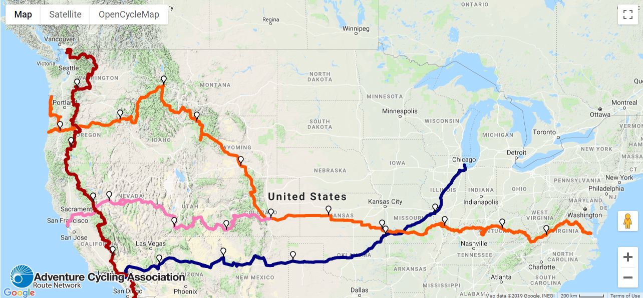
Big U Bike Tour Map.JPG

I start in Chicago (or north central Indiana). I follow U.S. Bicycle Route 66, the dark blue line, to southwestern Missouri. This route follows, to the extent possible, the old Route 66 highway. I switch to the TransAmerica Route, the orange line, and head west across Kansas and the southern half of Colorado. In Pueblo, Colorado I take a day off after 1,300 miles. I’ll need it. I leave the TransAm Route and head west across the Rocky Mountains and into Utah. If I have it in me, I’ll do a side trip to Bryce Canyon National Park. I’m not planning on hiking but the scenery alone in Bryce will be hard to pass up. 

Between Pueblo and South Lake Tahoe, California, there are dozens of mountains to climb. Most of them are higher and steeper than the seven climbs I did in Montana and Washington State last summer. My maximum elevation last year as a little over 5,600 feet. This route has climbs that go over 10,000 feet. To add to the difficulty there will be long stretches with no services, including no water. And did I mention some of these will be in desert? I bought a water filter and plan on carrying extra bottled water whenever I can.

I’d like to cut weight on this tour but there really isn’t anyway to avoid carrying a tent, sleeping pad, cold weather clothing, food, and water. The best place to cut weight is from the engine. Unfortunately, I now weight 213 pounds. No bueno. I need to be under 200 by the time I leave Pueblo.

Near South Lake Tahoe, I turn north along the Sierra Cascades Route. I thought this was going to be the hardest part of the trip, but now that I have seen the elevation map of Nevada, these mountains will be a relief (so to speak). This stretch of the tour will take me past Crater Lake. Once I get into Oregon, I’ll decide whether to continue following the Sierra Cascades Route to the Columbia River. There I can turn west following the river to the finish in Portland, Oregon. An alternative would be to switch back to the Trans Am route at Sisters, Oregon, climb over McKenzie Pass, and ride down to Eugene, or even continue to the coast. Either way, I would use the Google to route me to Portland.

Since I fully expect to be a hurtin’ unit for much of this ride, I have thought about places where I can call an audible and change or curtail the tour. For instance, I can cut out the Sierra Cascades entirely and ride one last climb west across the Sierras to Sacramento or, even, the Bay Area.

I planned a two-month itinerary, the same as last year, even though the tour is 700 miles shorter. The lower daily mileage has more to do with the availability of resources than with the difficulty of the route itself. For example, when I am faced with the option of a 45 mile day or an 80 mile day, I am planning on the 45 mile day. (I generally end up riding farther than plan because riding is preferable to sitting around a campsite or a motel.)

I plan to start on May 15. The original idea was to take Amtrak to Chicago. Mrs. Rootchopper has dangled the idea of driving me to her parents’ house in northern Indiana. I can ride west and pick up Route 66 in a day or two (and avoid the traffic of northern Illinois.)

I am open for suggestions as to what to call this tour. The Big U is one idea. YODO in the Wild West is another. If you have any suggestions, feel free to add them in the comments section.

Stay tuned.