Tour Options for 2024

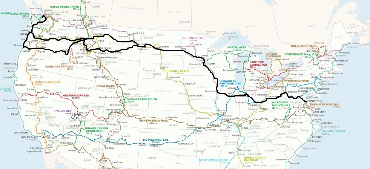
It’s starting to warm up and my thoughts are turning to a spring/summer bike tour. I have pared my ideas down to two tours, all originating from home and involving parts of the Atlantic Coast, Trans America, and Great Rivers South routes designed by the Adventure Cycling Association.

Pre-tour Jitters

I have some trepidation about this tour. Of course, pre-tour worry and anxiety is nothing new. It is tempting to let these feelings snowball, what Buddhists call papañca. There is some usefulness to anticipating problems, of course, but, left unchecked, this sort of mental proliferation can ruin your tour. About 50 miles into my 760-mile DC-to-Indiana tour, I was making myself miserable with pointless worrying. I stopped and gave myself a mental dressing down: “You’re on vacation. Relax. If bad things happen, you’ll figure them out.” It worked.

My list of worries is short. For a start, I am not a kid anymore. I was a youngster when I rode across the US alone in 2018 at the age of 62. I’m now 68 and don’t I know it. I have nagging physical issues with my lumbar and cervical spine. Also, I have the usual age-related reduction in muscle strength. The only cure for these things is to walk when I need to and to shorten my riding days to the extent practicable.

A second concern is dogs. The route I am taking is notorious for aggressive dogs. In the past I brought a small can of pepper spray. I never once used it gave me peace of mind. It occurs to me that on a windy day or on a downhill I am likely to spray myself. Yeah, let’s do 25 miles per hour downhill on a bumpy road with a snarling junk yard dog at my heels and get a load of pepper spray in my face. Nope. I am going to find a small horn of some sort and hope for the best.

Weather is always a concern. Since I am heading south, I am sure to encounter much more heat and humidity than last year. I’ll need to stay hydrated and take breaks. Depending on which route I take I’ll could be dealing with serious headwinds.

The topography is a bit intimidating. Like last summer, I’ll be crossing the Appalachian Mountains for a good chunk of the tour. In my mind’s eye this means steep climbs straight up one mountain after the next. That’s not how it works, of course, and I never seem to remember that those climbs are followed by descents.

Now, let’s consider the options.

Option 1: Finish the Trans Am

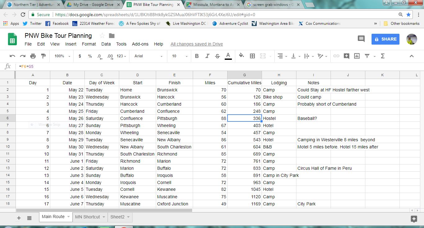
I have about left over 1,000 miles of the TransAmerica route unfinished: from Ashland, Virginia (just north of Richmond) to Ash Grove, Missouri (just east of the Kansas border). I’d ride south about 110 miles to Ashland then bang a right on the TransAm. And follow it over 1,400 miles to Ash Grove.

The eastern third of the TransAm Route

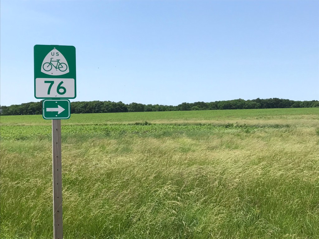
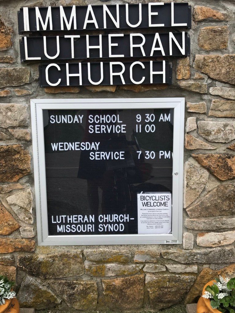
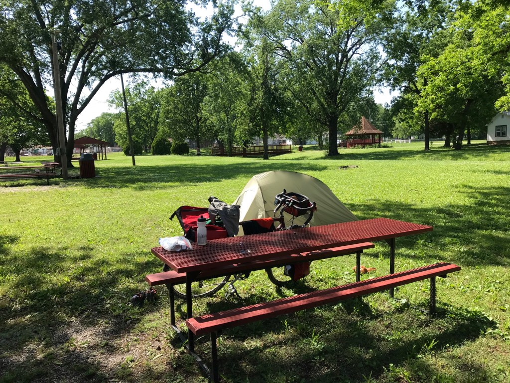
A big advantage of this part of the route is the lodging situation. There are something like 21 inexpensive places to stay including campgrounds, town parks, fire houses, hostels, churches, and such. Another advantage is the fact that I will encounter bike tourists along the way thanks to the popularity of the TransAm.

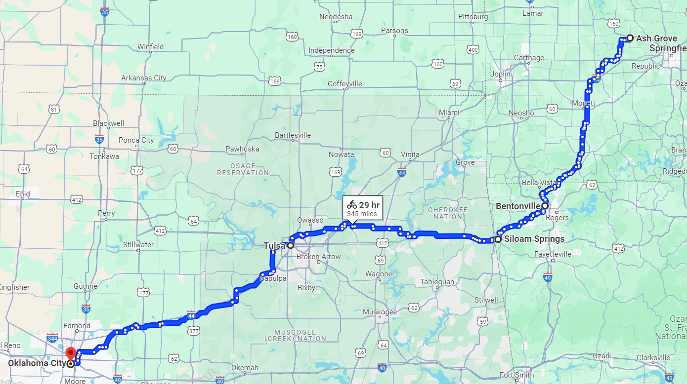
After Ash Grove it makes sense to me, at least, to ride south to Bentonville, Arkansas. This would take about two days and add 110 miles. There’s all kinds of flights to DC from this city thanks to the fact that it is the home of Wal-Mart.

Beyond Bentonville is the possibility of picking off Oklahoma. Tulsa is three days and 130 miles west. Add another 150 miles on old Route 66 and I’d be in Oklahoma City, another city with several flights to DC. All told, DC to Oklahoma City would make for a tour of about 2,000 miles. Tulsa and Oklahoma City have the added benefit of being on Southwest Airlines’ network, meaning I’d probably fly home for free.

Continuing on to Oklahoma City

Option 2: Laissez Les Bon Tons Roulez

This town is identical to the tour above until Marion, Kentucky just south of Cave-in-Rock. At Marion, I would pick up Adventure Cycling’s Great Rivers South Route, taking that to the start of the Natchez Trace near Nashville. With the exception of a detour to Muscle Shoals, Alabama to take in a bit of music history, I’d ride to Natchez, Mississippi. After that, it’s a few days of riding to New Orleans. The total mileage is about 2,100. Theoretically, I could take a train home from New Orleans but it would take at least 26 hours.

DC to Nola

I once had a business trip to Louisiana in April and could not believe how humid it was. Add ten or 15 degrees and you get pure misery. It probably would make more sense to just fly to Nashville, do the ride to New Orleans, and fly home. That would be about 900 miles and would take me about a month.

Bike Tour 2022 – Fort Scott to Erie

My apologies up front for not taking pictures in Fort Scott. There are several mansions that are now B&Bs. They have Victorian features but are built of brick, of course.

After the hotel breakfast I made my way south in search of a new bike lock. I tried to give my business to two hardware stores but their wares were inadequate. I ended up in WalMart and succeeded in a scoring a lame cable lock and some thin lube, Finish Line 2 in 1, which supposedly allows you to skip the chain cleaning step.

I put the lube on the moving parts of my front detailer and on the cable where it passes through the underside of the bottom bracket, the lowest point on the frame. I also tweaked the barrel adjuster on the cable to tighten it. I had one delayed shift to my granny gear all day. I’ll call that a success.

I rode south on a highway out of town into a 10 to 20 mph headwind. I decided to stop looking at my speedometer and just focus on constant effort.

Most of the drivers gave me plenty of room but as the day wore on the drivers’ patience wore thin. Oddly the only cars that honked were approaching not following.

After 20 miles of head winds I turned west to enjoy 34 miles of sidewinds. Having four panniers on my bike made the turn west a dubious improvement. The panniers act as sails forcing me to leave plenty of space between me and the non-existent shoulder.

I was now on US Bike Route 76, which a bit further on became the TransAmerica Trail.

I stopped at a Lutheran church that shelters bike tourists. I used the restroom, refilled my water bottles, and made off with some munchies. (Yes, brother Joe, I took some crunchy Cheetos.)

On this two-lane, 60 mph road I noticed a turtle making its way across the eastbound lane. I saw a car coming eastbound so I turned across the road and waved at the car to move over so as to avoid the turtle. The car slowed and, with the passenger side window down, the driver cursed at me. It was a kid who was apparently challenged by seeing an obstruction in an arrow-straight road in broad daylight. I didn’t react. I think the turtle made his escape.

About a minute later I was back on the right hand side of the road when a minivan pulled up beside me. It’s passenger side window was open and I could hear the driver raging at me. Just completely out of control. I didn’t look at him because I wanted to avoid his car which was very close to my left side.

He yelled that his kid was 14 years old and could have crashed because of me.

How reassuring!

He may be a crappy driver but at least he’s got the road rage thing down just like dear old dad. Mom was in the shotgun seat giving me the business too. I didn’t react. As they drove off Mom asked me why I swerved. “To save a turtle’s life.”

I may be mistaken but I doubt this was a family of Buddhists.

They turned around in the next driveway and roared past me. I waved. All fingers.

These back to back road rage incidents were only the fourth and fifth of my tours. I could go on about how inane it was. As I rode on it occurred to me that I was lucky they didn’t pull an Easy Rider on me.

A few miles later I rolled into Walnut where the local police had given me permission to camp in the town park. I stopped in the town convenience store and had lunch. A bologna sandwich on wheat with potato chips flavored with Argentinian spices, washed down with a Gatorade. Fine dining.

The store clerk told me that the town of Erie had restaurants and a park with camping so I lit out 9 more miles. Erie is two miles south of my route which meant two more miles of headwinds. I found a camp site conveniently near an empty RV slip where I could use a water pump and recharge my phone. All the comforts of home!

Despite the winds I pitched the tent without much difficulty. After washing up I headed to Main Street for vittles and grog. (Craft beer here is Natty Boh. I resisted the urge to ask for a Gansett.)

Tomorrow promises more strong southerly winds. I’m heading north for at least seven miles so I’m feeling the joy already. I’m looking forward to seeing bike tourists along the road.

Todays mileage: 48. Tour mileage: 525.5

Hello, old friend.
Bless me father for I have spinned.
Cuisine de Walnut
All the Groc you can handle
I was getting sick of motels.

Bike trip stuff

I’m starting to amass some new stuff for my bike trip. Two new Schwalbe Marathon Plus tires to replace the two I’ve been riding for a year and nearly 5,000 miles. (The old ones are still usable but won’t survive a long tour.)

A new Ottolock will replace my heavy U-lock. I’ll be mostly in rural areas so this should provide ample security. It’s a combination lock so I don’t have to worry about losing my key.

Spray on sunscreen for the ever growing solar panel on the top of my head.

And a pile of Adventure Cycling maps to keep me from getting lost.

I’ve also bought new Koolstop brake pads for my front and back wheels.

I’m going to buy a water filter and maybe a merino wool t-shirt before I leave.

About five or six weeks to lift off. Stay tuned.

Rain, Rest, Motivation, and Maps

Last night I took 2 ibuprofen PMs (ibuprofen with a sedative) to make sure my wonky left knee didn’t wake me. It worked. I overslept Friday Coffee Club.  This was pretty convenient because I would have ridden 15 miles to DC in a cold rain.

I needed the rest. I’ve been pretty disappointed with my body this winter. Sore knee, shoulder, hip, achy back,…., I want my mommie! Self pity won’t get my act together but exercises, new walking shoes, and riding my bike, alternating hard and easy days, will. So, for the last seven days, I rode 207 miles, mostly on my Cross Check. And I did a couple yoga torture sessions, a weight session, and two foam roller super six sessions. Each day included specific stretches for my iliotibial bands in hopes my left hip and knee will heal themselves.

Now that my body is starting to come around, I need to work on my brain. Bike rides and daily meditation are not getting it done. Two things happened the other day that should help. First, the maps for the middle part of my bike tour arrived. They span the gap between Pueblo, Colorado and South Lake Tahoe, California.  The thought of riding this section of the country is intimidating. I will sit down in the next day or three and do a day by day itinerary in the hopes of getting enthused.

The other thing that happened is I stumbled on a video blog about a coast to coast bike tour. Ryan and Ali are two film making fitness people who fell in love. Having been together only three months, Ryan didn’t want to ride across the country solo so Aly agreed to join him, despite her inexperience at bike touring. Being obviously smitten with each other they decided to interview people along the way and ask them the secret to maintaining their relationships with their partners. They called their tour LoveCycles.

To document the trip, Ryan made 37 videos, each about 20 minutes long. To be honest I found the love interviews a bit boring after a while, but the parts documenting the tour are amazing.  He even used drones to capture the spectacular landscapes and the two of them riding through them.

I’ve watched the first twenty videos. I was especially enthused by the first two that documented the Oregon beginning of their trip from Fort Stevens State Park (where I dipped my front wheel in the Pacific last summer) to Portland (where my trip ended).

Their ride through Washington State, eastern Oregon, Nebraska, and Wyoming is really beautiful. So if you want to get a sense of what bike touring is like out West, check their videos out.

There are a few things about their tour that differ from mine. First, they made up their route as they went whereas I use Adventure Cycling maps. It turns out the Google isn’t the best bicycle touring router. Yeah, well. On the plus side, they received great route advice from people along the way.

They also traveled with four panniers between them. How the hell they managed to do this and carry video equipment is beyond me. They each brought about a third the clothes that I do, for a start. Their two-person tent is about half the size (and weight) of mine. They have nothing on their rear racks and no fenders. So their bikes were considerably less heavy than mine. And their engines, lacking belly fat and boobage, were much lighter. (For what it’s worth, my father’s genome provided me with a competitively compact ass.)

People often ask me how I managed to ride across the country alone. After watching these videos you’ll see that spending 24/7 with someone under stressful conditions can be trying. (Much of the stress happens off camera, but they make it clear that the trip wasn’t all rainbows and unicorns.) After over 2,000 miles, I actually welcomed Martin’s fitful companionship as I rode through North Dakota, Montana, and Washington. It added variety to the proceedings. It’s a good thing he’s a nice person though. In general, however, solitude works for me.

So it’s back to the videos, only 17 more to go, then a big time bike planning and itinerary session.

Enjoy the rain.


Planning: Any Road Will Take Me There

  • I’m thinking of naming my bike tour the Any Road Tour. The reason is I can’t seem to decide on a route let alone a destination. And as lyric thief George Harrison said, if you don’t know where you’re going, any road will take you there.
  • So a special note to Tim Jones, Lindsey, and Brittany: I still don’t know if I’ll make it up to the Seattle area. As they say on the Facebook, it’s complicated. I should have a better idea if/when I get up your way in late June when I am somewhere near the Missouri Breaks.
  • The route options go through Missoula, Montana. They are:
    • Ride to Seattle directly from Missoula. Return home around July 22.
    • Ride through Portland then on to Astoria Oregon. Backtrack to Portland. Return home around July 24
    • Ride through Portland then on to Astoria Oregon. Continue north to Seattle. Return home around July 29
    • Ride to central Oregon Coast. Then to Portland. Then to Seattle. (I haven’t mapped this out). Return home around August 6.
    • Ride to central Oregon Coast then to Seattle by way of Astoria. Return home about August 6.
  • All these routes have pluses and minuses. And as Mrs. Rootchopper noted, I could make a separate, month-long tour out of them. (Seattle to Missoula to the central Oregon coast to Portland to Seattle, for example. Or maybe go south to Crater Lake…..)  So this routing uncertainty is a good problem to have.
  • I have met a couple of times with a local bike tourist named Marie. She and her husband Roy did nearly the same tour in 2015 and blogged about it. I didn’t want to read her blog because I thought it might include spoilers, but I finally gave in. It’s wonderfully written and contains all kinds of useful information.
  • I had lunch with Marie the other day. She gave me one of her Adventure Cycling maps of Oregon. And imparted some good advice
    • Feel free to wander from the ACA routes, especially east of the Rockies. There are some surprises, good and bad, to be had. The Google is a pretty good resource.
    • Each county seat in North Dakota has a motel (to sequester juries). So if I get sick of camping I can probably use the Google…
    • I will probably follow their route through the Twin Cities instead of around them. The ACA route goes east from St. Paul, then north, then west. Marie and Roy went northwest and re-connected with the ACA route.
  • Marie and Roy made the trip without camping. Other than staying with a friend or two, they just booked a hotel a day in advance and rode to it. They appeared to average about 2 miles per hour faster than I expect to ride.
  • With the weather finally settling into something resembling spring, I am getting antsy. I still have a few things to take care of for the trip, all of which happen just before I leave.

Tour Planning – Many Moving Parts

The longer the bike tour, the higher the probability of hitting snags. My trip to Key West was fraught with weather complications. My UP tour presented the possibility of sea sickness on three ferries. Both tours worked out fine.

This tour is twice as long as the Key West tour. I bought some bike touring maps from Adventure Cycling Association. Using these I constructed an itinerary in a Google spreadsheet.

Capture

This is the tab covering the main route. There is an alternate, slightly shorter route in Minnesota. That itinerary is on the MN Shortcut tab.

One thing I discovered is that there are beaucoup camping opportunities, including in city parks, presumably for free. Free is bueno.

I tried to make an itinerary that averages about 60 to 70 miles per day. Each day’s segment is determined by the availability of shelter. Food and water are generally available along the route, with the exception of a 78-mile stretch in Montana. As long as I know this, I can plan accordingly.

My route follows several ACA routes and, by design, goes through Missoula, MT, the home of the ACA. The map, that would guide me from Missoula to Clarkston, Washington along US 12, is out of stock. I did receive an addendum to this map, however. It notes that US 12 in Idaho will be closed intermittently for 50 miles this summer. Adventure Cycling is working with the Idaho DOT to figure out how to get its members through the construction zone.

I called Adventure Cycling for more information. They didn’t have much to say other than they are still trying to work something out with the Idaho DOT people. I guess they don’t call it adventure for nothing.

I do have a viable option, albeit one that pretty much rules out stopping in Missoula or riding through Oregon. This one would simply follow the ACA Northern Tier route across the top of Montana, Idaho, and Washington, ending in Anacortes, Washington. This is conveniently close to a high school friend’s home which I was planning on going to anyway. It is also at least 200 hundred miles shorter than the route I have been working on. So depending on how the US 12 situation plays out, I may just call an audible and take the northern route.

And another thing. I learned this morning that my son, who lives in Thailand, is thinking about coming home for a few weeks in July. He would be bringing his girlfriend, whom I have never met. So for obvious reasons I’d like see him while he’s here. Unfortunately, July coincides with my route being in the middle of nowhere. As the Christmas song says, I’ll have to muddle through somehow.


I hope I don’t forget the maps

Whenever I travel, I obsessively check for my wallet and keys. Losing them can ruin your whole day. On the second day of my trip from DC to northern Indiana, I lost my vest on the C&O Canal. (I made a hurried exit to get away from a camper who was grossing me out.) A few hundred miles later I was caught in the rain. I stopped at a convenience store and bought some 30 gallon garbage bags. I take a 27 gallon bag but you have to make do with what you can.

Today, the cleaning people came to our house. I took off for the gym.  It’s 3 1/2 miles but I went the long way to kill some time. By the time I arrived,I had ridden 22 1/2 miles. I dismounted and immediately noticed that my pannier which contained my lock was not on my bike. Oops.

Retracing my steps wasn’t an idea that pleased my frozen toes so I decided to ride home and see if I left the pannier there. I found the pannier inside the front door. I never carried it outside. Moron.

I rode back to the gym and worked out. By the time I arrived at home, I had ridden 33 miles.

This evening I began mapping out the route I plan to take to the Pacific Northwest beginning in late May. I had figured I’d do about 3, 700 miles. Wrong. It will be more like 4,200. Dang. I selected some maps from the Adventure Cycling Association. One was out of stock. I hope they print more or I am in a bit of a pickle.

Basically, the route goes from DC to Iowa, turns north to Fargo, North Dakota, then west to Montana. There it angles southwest to Missoula (home of Adventure Cycling) before turning west again for the Pacific Coast. I’m still trying to figure out where on the coast I should go. Once there I plan on heading north into Washington State where, if all goes well, I will flop on my high school classmate Tim Jones‘s lawn and declare “I will ride no more forever.”

All I have to do is follow the black line that I drew on top of Adventure Cycling’s U. S. route map. (Note how there are multiple routes through Montana to the coast.)

One of the cool things about this route is that it is all downhill and there are nothing but sunny skies and tailwinds.

My route to the PNW

No Way So Hey – Day 2 

After 88 1/2 miles yesterday I was up for an easy day. How’s 60 1/2 miles grab ya? 

I woke before the sun and waited for the rain to stop as it pitter pattered on the roof of my cabin. 

If I went and the rain returned in the form of mist with a dash of fog. I wore my reflective vest (thanks Bike Arlington) for visibility. 

My day began with a hill but it wasn’t as bad as I expected. In fact none of the hills today were all that difficult.

Unlike yesterday’s suburban bike hell that is officially called Prince William County, today’s ride was mostly rural. I was counting on breakfast at a country store about 20 miles into the ride. It was closed. Out came the granola bars. 

I ate six. Not exactly fine dining but it kept me from bonking.

I stopped to help a turtle cross the road. I thought of Ultrarunnergirl who did the same on a ride we did a couple of years ago. 


40 miles of farms and field led me to Ashland. Along the way my route US Bike Route 1 overlapped with the transAmerica bike route, US Bike Route 76.  If I took a right I could go to the Pacific! That’s for next year.

A major east coast rail line goes right through the center of town. The Iron Horse was the first eatery I saw. Good enough. I had a club sandwich. It was big as was the side of slaw. I was tempted by the beers on tap but Diet Coke won the day. The waiter kept me watered too. And he filled my bottles with ice water. 

The rest of the ride was straight into Richmond. I could tell when I saw the statue of A.P. Hill in the middle of the road. He was facing south. I rode up and down Monument Street and saw the ludicrously immense statues of Robert E. Lee on Traveller and J.E.B. Stuart with a dramatic cape. 

After seeing the capital building and rolling through the location shooting for Homeland, I headed to the hostel. It’s clean and cheapish. They have free laundry and breakfast and in a few minutes popcorn and evening entertainment. I am heading out for  vittles and grog. 

Once I got cleaned up I reviewed my route for the next few days. I managed to overlook about 70 miles of my trip so I may be getting to most of North Carolina a day later than planned. 

Oops.

Key West Bike Tour Planning

  • My Atlantic Coast Route maps have arrived from the Adventure Cycling Association. I spent an hour plotting a tour from DC to Key West.
  • There are many maps covering about 30 miles per map. Each one has tons of detail indicating camping, food and lodging locations along the way. Mostly this means that you have to curtail a day here and there to find a place to rest your head. It also means that getting past Miami will likely involve riding a century. This will not be a whole lot of fun.
  • Each of the maps has a narrative. Sections of the Florida Atlantic coast sound very unfun. There are long sections of the route with no bicycle repair facilities. Derp.
  • I addition to riding the main route straight to Key West, there are four optional side trips to choose from.
    • I can ride the outer banks of North Carolina. This adds 80 miles and about 2 days to the trip. It might also add a whole lot of wind. And sand. I’ll probably take the inner route since I have already driven the outer banks.
    • A spur route goes to Charleston. This would be fun. Another 2 days.
    • A second spur route goes to Savannah. Another 2 days.
    • There is an alternate route through the Okefenokee Swamp. This only adds 15 miles and I’ll almost certainly do it just for the bragging rights.
  • I tried to plot a course that averaged 60 miles per day. It’s not really doable, because of camping/lodging issues. I’ll probably end up averaging 70 miles per day which is okay since I don’t expect to be dealing with a lot of hills once I get to North Carolina. I am more concerned about wind and thunderstorms and meth addled rednecks and alligators. Oh my.
  • A possible alternate route would take me diagonally through Florida from Jacksonville to Orlando and on to Fort Myers on the southwest coast of the penninsula where I would take a ferry to Key West then ride back to Miami. The instructions for riding in Fort Myers are pretty scary. (Ride on sidewalk. Take the lane. Call your momma.) Also, this diagonal route might cause me to bypass Saint Augustine which might be the coolest thing ever.
  • I am still debating with myself whether to do this as a straight unsupported tour or to do Jacksonville to Key West as part of a supported charity ride. The charity ride has lots of logistical advantages. Basically I’d flip the tour on its head. I’d have the bike transported to Jacksonville at the start, ride back to Key West, then get a lift in the support support van, back to Jacksonville, and ride home). The charity ride adds the burden of raising $2,000 by October. Over the last weeke or two, I have watched a friend drive herself to distraction raising money for a charity (for a different ride) in the last couple of weeks. Being a world class introvert, I honestly don’t need the stress nor do I feature hitting people up for money. Worst case scenario: I raise only a couple hunder bucks and I’m on the hook for the shortfall.
  • I can think of a thousand reasons not to do this trip at all. So the thought of just getting on the damned bike and riding until I run out of road has a very strong appeal. I can figure out the return logistics once I get to the Keys. There are three options: fly back, take a train, or rent a van and drive my ass home. What I don’t want to do is schedule the return too far in advance. Then I would stress out about meeting a flight or train for the last week or two. The best option is to fly Southwest back (using points) and ship the bike home via bikeflights.com.
  • I know of 3 or 4 people who live directly on route (depending on my specific route). I am not above mooching a layover at their places.
  • Finally, there is the unanswered question: what size bike pump would I need to fend off meth-addled rednecks and alligators?


Planning 2017 – At Last

After two months of dithering, I have finally started to sketch out my battle plan for 2017. I have only a couple of solid commitments to deal with and the rest is flexible.

Solid Commitments

  • Volunteering – because every time I see Michelle (WABA’s event manager) I feel guilty.
    • Vasa Ride – I’ve done this ride several times during the event and on my own or with others during the summer and fall. It’s well worth doing and you should give it a go. I mean when was the last time you had warm blueberry soup?
    • Tour de Fat – I am a trained beer puller. I have two hours of Tour de Fat beer pulling expertise. It would be a shame to let my skills evaporate like beer suds.
  • Family Events
    • Holy cow, my daughter’s graduating from Butler University. Woot! (This one is not at all flexible.)
    • Family reunion – this is in the middle of July.

Bicycling Events

This is a much shorter list than usual but has two new (to me) rides.

  • Car-Free Skyline Drive – I just heard about this today. It’s a brutally hilly road but, well, no cars! Also, I totally suck at hill climbing.
  • Bike to Work Day – probably my last one. Not because I don’t like the ride but because I am retiring in August.
  • Tour dem Parks – A ride around Charm City (Baltimore) that has very good word-of-mouth reviews. Also I might get to meet Eleanor (who was a bun in the oven the last time I was in Baltimore) because I hear she is swell.
  • 50 States Ride (my 10th!) – Need I say more?

Baseball

So far, I have committed to an exhibition game against the Red Sox on March 31 and an Orioles v Red Sox game in April in Baltimore. I blocked out on my calendar all the weekends that the Nationals are at home. If you want to go to a game with me, I am tolerable company. I can provide references. Also, I will shamelessly accept any tickets you get comped or otherwise stuck with. Also, there are two road series against Philadelphia. I might drive up for a day game just for the hell of it. Wanna ride shotgun?

Hiking

When the Nats are not playing I have free weekends. So these are all potential hiking days. My white board list of hikes is pretty similar to last year because I failed miserably at hiking last year. Doh.

  • Potomac Heritage from Turkey Run to Chain Bridge and back
  • Thompson Hollow Loop
  • Buck Hollow/Mary’s Rock
  • Double Bear Rocks
  • Stairway to Heaven
  • Broad Hollow/Pine Hill Gap
  • Loudon Heights/Split Rock
  • Jones Run/Doyle River
  • Corbin Mountain
  • Fountainhead

Mostly these are in the mountains to the west. If you live in the DC area and don’t mind getting up at the crack of dawn, feel free to come with. As with biking, I may be old but I am slow.

I could also use these non-Nats weekends for bike trips. Maybe an out and back between Williamsburg and Richmond on the new-ish rail trail.

Foreign (?) Travel

My daughter is thinking about going overseas for grad school so this would be an excellent excuse for a trip. If she goes to school in the US, this will require a college move-in road trip. Also, my son may still be in Thailand next winter. I wouldn’t mind seeing the place when it’s not pouring rain.

Bike Tours

Since I am retiring in August, I am saving up my annual leave for a big check. Once I get the 50 States out of the way, I think I might ride somewhere warm. Key West sounds like a good destination. The rough plan is to take the Adventure Cycling Atlantic Coast Route about 1,500 miles to Key West, take a ferry to Tampa, ride across Florida to Miami and take Amtrak home. I figure this will take about a month to do. This would be the warm up for the big one in 2018 which will probably involve riding to the Pacific Northwest.

Also between my birthday and the 50 States Ride I may have time for a short tour. I have no idea what that might entail. Maybe a road trip to rail trails in Virginia. Or the Grand Canyon of the East.