At my 25th high school reunion my classmates and I lined up for lunch. The line next to us comprised the 50th year alumni. Overhearing their conversations, I couldn’t help but laugh. All they talked about was the diseases and operations they had been dealing with.
Of course, now that I am at the tail end of my 60s, I am finding that medical woes are the topic du jour no matter where I go. At Friday’s Coffee Club we had three shoulder impingements and one post-op rotator cuff. My shoulder impingement is an interesting diversion from my whiplash recovery (nearly complete), my lumbar spinal stenosis, my wrecked left knee (nothing new), and my recovery from carpal tunnel surgery.
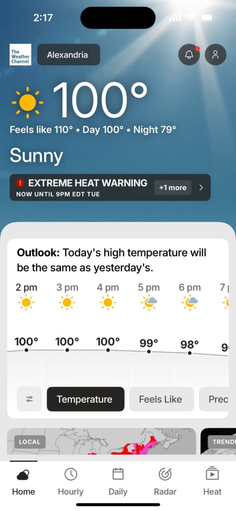
Another thing that seems to be new is my difficulty in dealing with excessive heat and humidity. Aren’t old people supposed to love hot weather? This summer in the DC area has had it usual oppressive, swampy weather. Lately when I finish a ride in “feels like” 109 degrees F, I need to drink a gallon of whatever I get my hands on and take a nap.
You don’t want to know what it feels like. Trust me.
That hourly chart makes me super glad I hired out lawn mowing this year.
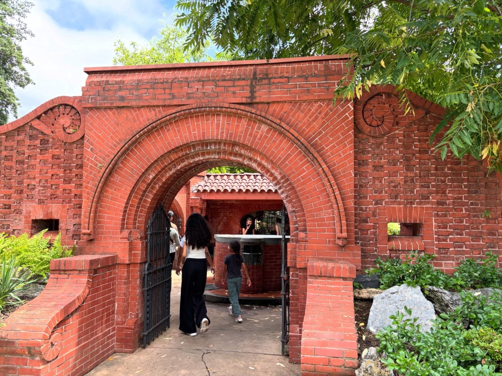
It’s at least ten degrees cooler inside this outbuilding on Capitol Hill.
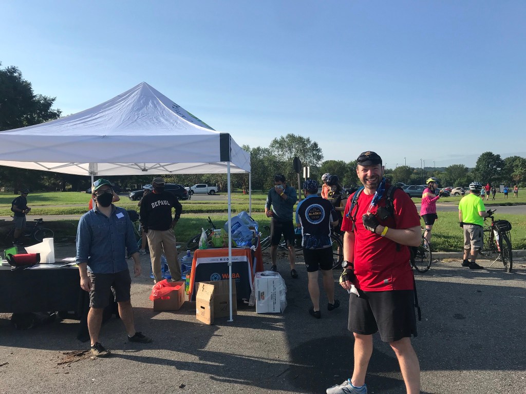
The heat and humidity does provide us with some entertainment. We routinely have raging thunderstorms. The other day I was doing a 50-mile ride on Big Nellie when I came upon a tree that had fallen across the Anacostia River Trail in DC. Fortunately, a young whippersnapper (in the green jersey below) helped me by hefting my bike over the tree and sent me on my way.
Another recent storm dropped a tree from my neighbor’s property into my backyard. Most of what fell in my yard was from the top of the tree. My neighbor was not at all concerned that his rotted tree had left a mess in my yard. Thanks, pal. I decided to return the wood to its rightful owner and threw it over the fence onto his derelict property.
The other night another line of storms came through. A tornado warning was posted for the northern edge of DC about 25 miles away. I was sitting in my kitchen when the loudest bang and biggest flash went off right over my house. The floor shuddered. WOW! Somehow the lightning bolt didn’t cause any damage other than my frayed nerves.
The heat and humidity does bring some interesting flora. The lotuses, water lilies, and other marsh flowers were in full bloom at the Kenilworth Aquatic Gardens in northeast DC. This, combined with Friday Coffee Club, made for a nice 48-mile jaunt on Big Nellie.
Speaking of Big Nellie, I have gone full on bent, riding it for 460 miles over the last two and a half weeks. My right arm, the one with the impingement, is happy.
A week ago my wife and I signed up to use the newly renovated recreation center three miles from home. I used to go there to lift weights before the pandemic. It had a crummy little weight room but it served my purposes. The renovated weight room is massive, with brand new equipment. Lifting helped my riding, especially during my recovery from pulmonary embolisms back in the winter of 2017 and 2018. I use only upper body machines with very light weight. I concentrate on going very slowly. One interesting result is that my upper back can now comfortably lean back when I am sitting. This makes for a much more efficient and comfortable ride on my recumbent.
Saturday was the Washington Area Bicyclists Association’s annual big fundraising event: the 50 States Ride. The ride is a triumph of marketing over sanity. Participants pay $80 to ride 60 hilly miles in the heat and humidity (when it’s not raining), all within the eight wards of the District of Columbia. Did I mention that the streets are open to traffic? We’re havin’ fun now!
This year was the 21st running of the 50 States and my 16th time participating. I’ve been riding WABA events with Chris, Michael, and Kevin for several years now. Remarkably they have not grown tired of my company. A couple of years ago Chris invited Sara with whom he worked. The five of us form the core members of the posse. (Domitille, a sixth recent member, had to miss this year’s ride due to injury. We hope to have her back in the fold for WABA’s Cider Ride in November.) Our posse members invite others to join us. This year Chris invited Isabon, Sara invited Jenna and Richard, Kevin invited Neena. Isabon brought her father, Wolfgang. Monica, who rode the last couple of rides with us, decided to volunteer at a pit stop but sent along Constance and Mac.
The course changes every year. Lately it has gone clockwise around the city. The course is tweaked to show off new bicycle infrastructure, sponsors’ projects, and changes to the cityscape. Having done this ride since 2006, I can attest to the fact that DC today is vastly different than it was 18 years ago.
Funny. It looks flat on this map.
The dozen of us lit out from the start in the Edgewood neighborhood smack dab in the middle of DC. We timed our departure to avoid other groups whom the ride organizers send out at intervals with ride marshals. We don’t mean to be antisocial but when you get over 20 people of different skill levels riding together in the city the congestion can get stressful. There were a few miles where we were bunched up with other groups but by and large we were successful riding as an independent unit. As is often the case, we adopted a couple of course marshals, Micah and Stephen, along the way. At the rest stop around 45 miles into the ride I was greeted by an old friend. John is the father of one of my son’s best friends from high school. He was riding the event for the first time and looked considerably fresher than me.
Two Johns at the Wegman’s pit stop in Northwest.
Michael decided to ride the entire ride on bikeshare bikes. Every so often he’d veer off course to trade in his bike for another. I think he gets some sort of points from the bikeshare folks and avoids rental charges. He managed to obtain electric assist bikes for the hillier sections. We hate Michael.
Chris told me that his GPS file indicated there are 11 significant climbs along the route. I counted 45, a triumph of misery over digital mapping science. The worst climb goes one steep mile from MacArthur Boulevard to Macomb Street in the northwest section of the city. After a brief downhill, this monstrosity is followed by a second, soul-sucking half-mile climb up Cathedral Heights. Six miles later we descended into Rock Creek Park only to climb right back out for a mile. Dang.
Instead of using the digital file, I use the paper cue sheet. Actually, it’s a 18-page booklet containing nearly 270 cues. This virtually ensures that I will make a wrong turn. This year I set a PR, making four wrong turns. (Actually one was semi-intentional as I saw three of our riders obeying the GPS audio instruction and turning a block early and going off route. I followed them in order to lead them back to the course.) Ironically, earlier in the ride after we crossed over the Washington Channel, a course marshal made a wrong turn entering East Potomac Park. I ignored the error and stayed on route. The Mule abides.
The clockwise course seemed somehow hillier than in prior years. I struggled for most of the ride even though The Mule had a new, lower climbing gear thanks to Beth at Bikes at Vienna. It may have just been the heat (mid-80s) and humidity at work or perhaps the fact that I’m old, decrepit, and grumpy.
By 58 miles I had had enough. We could have gone straight to the finish but the course meandered through the campus of The Catholic University, along the super nice cycletrack on Irving Avenue Northwest, and past the bizarre looking McMillan Sand Filtration site which is being developed into a mixed used community by one of the event sponsors. After McMillan we had a tedious one-mile ride in heavy traffic to loop back to the finish.
After the ride, the posse hung out at the after party which, owing to our slow riding pace, was all but over. Still we ate some sammies and hydrated our weary bodies. (I went all Stanley Kowalski and had a Stella.) I guess the ride was a success because several posse members expressed an interest in doing the (considerably easier) 60-mile Cider Ride in November. Well done, y’all.
Most of the posse after the ride. Clockwise from left: Richard, Chris, Me, Sara, Michael, Constance, Mac, Jenna, Micah, Kevin, Neena.
Many thanks to all the volunteers and WABA staff for all their hard work on this event. Special thanks to Mike and Lisa who convert their home in Tacoma into a very welcoming pit stop every year. And to Patti Heck who stood at the corner of Alaska Avenue and Geranium Street Northwest to take photos (links above) of riders as she has done for many years now.
It is said that bad things happen in threes. You hear about some famous person dying and within days two more follow. It’s creepy.
About two weeks ago, my friend Ed, co-founder of Friday Coffee Club, was out riding with some randonneuring friends when he was hit by a driver. According to Ed, it was a glancing blow of sorts. It actually sounded like my collision many years ago. Unfortunately for Ed, unlike slowpoke me, he was going 23 miles per hour when he collided with the stop-sign runner, who left the scene of the crash without stopping. Ed has some significant injuries. I saw him yesterday at Friday Coffee Club. (No, he didn’t ride there.). He looks good if you ignore the bruising, the arm immobilizer, or the back brace.
About a week later, Ricky was riding to Friday Coffee Club. It was a lovely near-winter morning when he decided to take a spin around the Tidal Basin, the pool of water ringed by Washington’s famous cherry trees. These trees have stout low hanging limbs. It being that time of year when the sunlight strikes from a low angle, the limbs were backlit, rendering them invisible. Ricky hit one hard. He came away with facial lacerations and a broken nose. He drove to Friday Coffee Club yesterday. He’s doing okay. (You should see the other guy.) He and Ed made quite the couple.
Today I learned that Jeanne, a friend who I see at every riding event in DC, had a “freak bike accident” over Thanksgiving. She broke her back and is recovering at home in a back brace. She’s an incredibly upbeat person so I know she’ll weather this, but it will be a few months before she’s back on her bike.
So yesterday I was riding to Friday Coffee Club. I crossed 17th Street NW at Constitution Avenue in a crosswalk with the walk sign illuminated. A dump truck driver made a right turn right in front of me. As he lumbered past, I could see that the driver was holding his cell phone up to his face. I guess it wasn’t my time to die.
So thanks to Ed, Ricky, and Jeanne’s for using up the three bad things. It would’ve sucked if I were the fourth.
Get well you three. Stay safe. Have a merry. Have a happy new year. Let’s hope it’s a good one without any fear.
It happens every autumn. Seemingly sensible people pay good money to ride 62 miles all over Washington, DC for the right to say, “I rode 50 states in a day.” The 50 States Ride is the Washington Area Bicyclists Association’s biggest fundraising ride. Participants ride through all eight wards of the city, up and down hills, through alleys, on side paths, over bridges, and past stadia (active and derelict) following a route that takes them on the streets named for all 50 states plus the District of Columbia (Columbia Road to be specific). The event takes place on open streets, meaning riders share the roads with everyday DC area drivers. Eek.
This year was the 20th anniversary, not to mention my personal 15th anniversary, of the event. Every year the route is tweaked, partly to make things interesting for returning riders but also to guide riders through interesting new sites like new multipurpose developments and new bike infrastructure. The organizers at WABA threw participants a curve ball this year by changing the direction of travel from counterclockwise to clockwise. Once familiar streets were now backwards. Bring it on.
Although the ride is 62 miles long, if feels like it is much longer. DC is surprisingly hilly. And, like any big city, has scores of stops signs and traffic lights. You have to slog your way up the hills, but the downhills are interrupted by traffic lights and such. This makes the route feel much longer. It also means that it takes about 50 percent longer than a 62-mile ride in the country.
I arrived at the start (and finish) at the Kraken indoor sports facility at 7 a.m. Kraken is pretty much in the middle of the city. I met up with my posse, a rag tag group of people, many of whom were new to me. Posse regulars Michael B., Kevin W., and Chris M. returned for the fifth or sixth time. Sara, a 2022 50 States rookie, came as well. Domitille, who joined the five of us on the 2023 Cider Ride last November, surprised me by joining the gang. I invited Monica who normally volunteers to sell merchandise at WABA events. Monica is a veteran of many DC Bike Party events. These are anarchic rides at night through the center of the city. Monica make a good anarchist. Rounding out the group were Jacob and Bryan, and Lili and Nina.
The twelve of us launched at 7:45 following the course through Northeast DC. The clockwise routing meant that we rode on Michigan, South Dakota, and Montana Avenues before they became mid-day traffic sewers. We continued south through Ivy City and Trinidad to the Capitol Hill and Hill East neighborhoods knocking off West Virginia, Maryland, Tennessee, North Carolina, Pennsylvania, South Carolina, and Kentucky is rapid succession.
Next we cruised along the west side of the Anacostia River and passed RFK Stadium, former home of the Washington [Old-Racist-Name] Football team. After a pit stop, we picked off Oklahoma Avenue, crossed the Anacostia River and, using trails, side streets, an alley, and a pedestrian bridge, we made our way to Minnesota Avenue in Southeast DC. Minnesota is another trafficy mess but the new route kept us on it for only a tenth of a mile.
Winding our way through streets in Anacostia, we came to the first hill of the day, the climb up Texas Avenue to, eventually, Alabama Avenue. We stayed on Alabama for three miles, the second half of which was a screaming downhill. I blew right past the left turn on 18th Street, thereby continuing my tradition of messing up at least once during the ride.
After I did a u-turn, I headed down 18th Street to Mississippi Avenue. Mississippi would be a great one-mile, flat romp but for the enormous speed humps every two hundred yards. At Wheeler Road, we climbed up a steep hill back to Alabama. After some side streets, we turned onto Martin Luther King Junior Boulevard, the main drag of Anacostia. MLK goes through the Saint Elizabeth psychiatric hospital complex (once home to John Hinkley, Jr.) then downhill toward the elevation of the Anacostia River. I bombed down this hill, barely touching my brakes. The bumpy asphalt made for a scary fun descent. The rest of the posse probably thought I was crazy. Who am I to disagree?
We crossed back over the Anacostia on the 11th Street Bridge and followed a path on the river back along the Navy Yard complex until we reached a pit stop across the street from Nationals Park. This was the half way point. The posse was still in one piece although a few of us were pretty worn out from the big climb to Alabama. I let the rookies know that the next eight miles were relatively flat. (Yeah, suuuurrre.)
With temperatures rising into the seventies, layers were removed for the second half.
We left the stop and rode past Nats Park, Audi Field, and Fort McNair on a series of protected bike lanes. M Street turned into Maine Avenue, past the District Wharf neighborhood. After a short rise to L’Enfant Promenade we used a side path along I-395 to cross Washington Channel to reach Ohio Drive in East Potomac Park.
The 3.5 mile ride down to Hains Point was a nice break from car traffic, but soon we were back in the thick of things riding up 15th Street to Independence Avenue, heading east. A zig and a zag had us riding on Virginia Avenue for a few blocks. More zigging and zagging put us onto Washington Avenue at the base of Capitol Hill.
D and 2nd Streets took us gradually over the hill, and with a few more turns and a side walk we were on Delaware Avenue on the north side of the Capitol. After riding down the hill, we were to take a right on Louisiana then a quick left (after 0 miles on the cue sheet) onto North Capitol. (We actually missed the right turn and only a day later did I realize that the slip lane we used to turn onto Louisiana was actually North Capitol Street. Many other riders went up Louisiana to E Street, missing North Capitol entirely. The confusion is really the product of the fact that the DC street grid includes two grids, one at 45 degrees to the other. Oy!) In any case, we diffidently tagged Louisiana then quickly turned back onto North Capitol.
For the next four miles we rambled through downtown bagging New Jersey, Indiana, New York, Vermont, and Rhode Island Avenues, stopping at a pit stop along the way.
The route became a bit more rolling as it crossed up and past the Adams Morgan and Kalorama neighborhoods using New Hampshire and Florida Avenues, California Street, Wyoming Avenue, and Columbia Road before riding briefly past several embassies on Massachusetts Avenue.
Having disposed of several states in a couple of miles, we now crossed Rock Creek Park on the Q Street bridge into and through Georgetown, exiting to the west on Reservoir Road. Reservoir took us to MacArthur Boulevard which was mercifully flat, the calm before the storm.
With a right onto Arizona Avenue, we began the big hurt: up steep Garfield Street for a lung-burning quarter mile. Garfield topped out at University Terrace which continued up for another quarter mile. (This climb was part of my first two 50 States Rides back in 2006 and 2007 except this time the pavement was new and smooth.) University connected with still more uphill on Loughboro Road which became Nebraska Avenue.
I had been trying to ride just ahead of the posse most of the day in the hope of spreading us out a bit. For a good deal of the ride, however, our group was joined by other riders making my good intentions futile. When we reached Garfield, I decided to shift into my granny gear, find a comfortable rhythm, and climb as if on my own. Once I had the rhythm I stuck with it and I made it up in good shape.
After a bit more climbing we turned onto Macomb Street. At the top of one last bit of uphill, I stopped to wait with Monica for the posse to reassemble.
No rest for the weary was the order of the hour as we dipped and climbed over Cathedral Heights on New Mexico and Idaho Avenues coming to a pit stop at the new City Ridge development. This new neighborhood epitomizes something that I love about this ride: every year, the ride showcases new features of this dynamic city.
At the pit stop I learned that an hour earlier Annette had texted us that she had a flat. I had no idea that we had lost her. We lingered at the stop for 20 minutes or so as Lili and Nina arrived looking tired but determined.
They elected to rest a bit more as the remaining posse members headed out for the last 15 miles. The route took us briefly on busy Wisconsin Avenue before winding through side streets around Fort Reno to Connecticut Avenue. After Connecticut, we rode through Chevy Chase DC using Nevada and Utah Avenues.
Next was the dip into the urban canyon of Rock Creek Park, riding on Oregon Avenue along the way. After a mile of riding the flats on the park floor we turned to climb out of the park using windy, shaded Sherrill Drive.
After a merciful red light, we took a left on 16th Street and a right onto Alaska Avenue, appropriately the northernmost state street on the route. Turning off Alaska onto Geranium Street, we passed Patti Heck, an amateur photographer who takes pictures of every rider who passes by.
The downhill on Geranium took us into Takoma DC where we stopped at the last pit stop at the home of Mile and Lisa on 8th Street. Snacks! Mile helped Rosanne with a problematic shifter cable. Eight iles left babee!
As we were about to roll out, Lili and Nina arrived giving us confidence that they would finish the trek in our wake.
We headed south and eventually east across the Petworth area, conquering North Dakota, Missouri, Colorado, Georgia, Arkansas, Iowa, Kansas, and Illinois. The posse could smell the finish line.
At this point, Michael, who knows the city far better than I, was leading. (Okay, he also had the GPS file of the route pointing the way, but still.) I would surely have taken us off course at least twice. We finally reached the 50th State: Hawaii. (Well played WABA.)
After that, it was downhill and past Catholic University and back through Eckington to the finish at Kraken.
We assembled inside for food and drink and conversation. Normally, at least one person says, “Never again” but not this time. There was even talk of re-uniting for the Cider Ride in November.
What fools these bicyclists be.
Many thanks to the good folks at WABA, especially Jordan Mittelman. Jordan was the lead staff person who designed the clockwise route and had to deal with an unprecedented, one-week weather delay. Thanks also to the volunteers who staffed the start, the pits stops, and the finish as well as the course marshals who did their best to keep us safe throughout the ride.
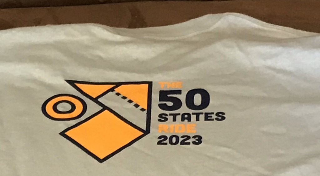
I have no idea what these symbols meanLogo from back of shirt
The George Washington Memorial Parkway, despite its name, includes many other facilities besides the roadway. This component of the National Park System is a hodgepodge of disparate things that were thrown together years ago. One of these facilities is the Mount Vernon Trail. Plans are underway to rebuild the Parkway and Trail. Parkway construction upriver from Washington has already begun. The Park Service is taking comments from the public as part of the project’s required environmental assessment (EA). I took the opportunity to provide some. (I subsequently made one more comment that I neglected to save.) A few comments relate to the roadway, most discuss opportunities to improve the trail.
As the comments show, I am not a big fan of the GWMP administration. It’s nothing personal. Like the rest of the National Park System, the GWMP is grossly underfunded and has been for at least a couple of decades. Cutting taxes has its consequences. The problem which I will discuss in a future post go well beyond funding.
I am a 39 year resident of Northern Virginia and a 33 year resident of Mount Vernon. I have logged tens of thousands of miles on the Mount Vernon Trail on my bike. Years ago I also used the trail for running. Before retiring in 2017., I commuted by bike year round from roughly mile 5 to DC and Rosslyn. I am a long time member of the Washington Area Bicyclists Association and the Adventure Cycling Association.
The trail is subject to flooding in the Dyke Marsh area, about 1 mile south of Alexandria. In the area immediately north of the long wooden bridge, the depth of the water already approaches one foot (it came over the top of my hiking boots while I was riding through it on the way to work one morning). You may want to refer to the re-routing of the trail north of Slaters Lane about 25 years ago. Any trail improvements must include raising the trail. At today’s water levels, a few inches is insufficient in Dyke Marsh and many other areas. Future water levels will surely be higher and the trail redesign should take this into account. In addition to the Dyke Marsh area the trail should be raised wherever the trail is in close proximity to the river as it is in spots south of Fort Hunt Park, in the Daingerfield Island area, on the northbound approach to the Memorial Bridge, and between the Memorial and TR bridges.
The trail needs proper drainage. Especially in the area north of Northdown Road. The trail in this area is subject to stretches of black ice in winter. In the short term this area would benefit from signage that warns users of icy conditions on the trail. (The current signage only refers to bridges.)
The trail needs to be level, except where curves in the trail require otherwise. In many places the trail is canted toward the river, presumably to provide drainage. The slant in the trail causes inexperienced riders to veer off the trail and is particularly hard on runners’ knees.
The 2020 NPS report on the trail did not properly consider trail use during non-daylight hours. There are numerous areas where southbound nighttime riders are blinded by the headlights of northbound vehicles on the Parkway including along the pinch spot near the auxiliary runway at DCA, at the oxbow at Daingerfield Island, and at the southern most point of the Four Mile Run bridge. I have nearly hit other trail users because of this and have witnessed collisions. This is a BIG problem for commuters. In the short term, inexpensive remedies such as snow fences or other barriers such as bushes should be installed.
The trail surface needs to be treated in winter. Just like the Parkway. Trail users can’t safely commute on ice and snow anymore than drivers can.
Light use of the trail in Fairfax County is not a reason to delay the renovation of the trail. Light use is a consequence of neglected maintenance and the shoddy condition of the trail.
The trail is part of several long distance bicycle touring routes.There is no viable alternative to the Mount Vernon Trail for north-south bicycle tourists in the DC area. Bike tourists (and others) have complained to me that the condition of the trail is so bad that they asked me for alternatives. One southbound tourist I talked with was even considering riding south on US1 in Fairfax County.The extensive damage to the trail south of the Beltway constitutes an unsafe condition for park visitors and needs immediate attention. I have advised Adventure Cycling of the trail conditions so they may warn their members.
Most of the bridges on the trail are made of wood. Other surfaces need to be considered. A particular shortcoming is the fact that the wooden bridges cannot support emergency vehicles or maintenance vehicles such as those used to plow snow or spread surface treatments in winter. To avoid damage to a wooden bridge. I once guided an ambulance carrying a crash victim in reverse about 1/4 mile up the trail to Northdown Road. At a minimum the Park Service should establish access points for emergency responders so that this doesn’t happen.
The trail now functions (if it didn’t already in the past) as a fifth lane of the GW Parkway and should be maintained, operated, and funded as such in the future. When the Parkway incurs damage that is dangerous to motorists, the damage is repaired and removed promptly. This hasn’t been the case with the trail for many years. Contracts for trail storm damage remediation should be in place year round. For example, there is extensive trail damage between Alexandria Ave and Tulane Drive. A massive root ball and tree trunk have obstructed the trail since late 2020 (or earlier). The damage worsened after a January 2022 storm. obstructing the trail. One half of the trail is obstructed. (Would you allow a lane on the Parkway to be in this condition for this long? Bridge 19 was damaged by a fallen tree in January 2022. It is missing a section of railing and two other sections of railing were damaged. The Park Service should at least install some yellow safety tape to alert trail users of the hazard.) And there is extensive washboard from root heaves and potholes from one end of the trail to the other.
Over a decade ago the Park Service considered building a bypass at Gravelly Point. For visitor safety, the bypass obviously is needed and should be built as part of this project. The airplane viewing area is one of the busiest parts of the trail and a permanent restroom facility is needed here. Porta potties are inconsistent with the aesthetics of the GWMP.
Much of the routine maintenance of the trail is now performed by volunteers, many of whom are affiliated with The Friends of the Mount Vernon Trail. For all their hard work, the Friends provide only one full time equivalent worker each year to trail maintenance. The Park Service doesn’t even fund their equipment. This is not nearly enough. Much of the work they do used to be performed by park employees and landscape contractors. Unlike DC, we have no Trail Rangers on this side of the river. In the short term the Park Service should amend its landscape contracts to require edging of the trail. (The contractors currently do this on the loop road in Fort Hunt Park.)
Recent re-striping of the Parkway between Tulane Drive and Morningside Lane runs along the right side of the roadway. In the area leading up to Morningside, this section of the road floods on a regular basis. In winter this often turns into thick ice. The striping should be moved to the left lane (as it is at Alexandria Avenue) for safety.
Turning north onto the Parkway at Morningside Lane is inherently dangerous. Absent installing a traffic light, I recommend eliminating this turn.
The situation at Belle Haven Road and Belle View Boulevard cries out for much more than some paint, stop signs, and flexposts. Unless legislation specifically prohibits them, traffic lights should be installed. Absent that, traffic circles of the type used on nearby Oxon Hill Road south of the outlet mall should be considered.
At-grade crossings for bicyclists and pedestrians are not likely to succeed. Build a bike/ped overpass that connects to the trail. Even an at-grade crossing should have a paved connection to the trail. And flashing lights that are passively activated such as at the northbound Parkway approach to the Memorial Bridge should be included in the design.
The entrances to the trail at Daingerfield Island and Belle Haven Marina merit stop signs for motorists. Trail users’ safety should take precedence over motorists’ convenience. (I was hit by a car on the trail at Porto Vecchio condominium a few years ago. After I presented testimony at a city meeting, the city changed the signage and traffic light sequence.)
Oxbows such as the one at the old Bridge 12 location near Fort Hunt Park are inherently dangerous. The similar trail configuration at Bridge 1 should be removed as part of the rebuilt trail. I crashed there and my injuries resulted in a visit to the Mount Vernon Hospital emergency room. My bicycle was ruined. This bridge and the approach from Mount Vernon replaced an even more dangerous original design. Clearly, half measures are not enough to ensure public safety. Another oxbow exists at Daingerfield Island. This one does not involve a bridge but I have witnessed far too many crashes and near misses as south-bound bicyclists come downhill into a sharp curve. A simple solution is to make the approaches gradual. This would also bypass the area of flooding immediately south of the oxbow.
In general, changes to the road and trail that improve visitor safety are in the public interest and should be given precedence over aesthetics.
Thank you for the opportunity to comment on this project. Feel free to contact me for clarification of any of these points.
I woke up this morning to light rain and moderate temperatures. I briefly thought of riding to Friday Coffee Club in DC. Normally it would take a bit over an hour to get there then another hour plus of hanging out before riding home at 10 or 10:30. I checked the hourly forecast. It called for a big drop in temperatures around that time. Basically, I’d be racing a crazy cold front all the way home. I decided to forgo the ride and stayed home.
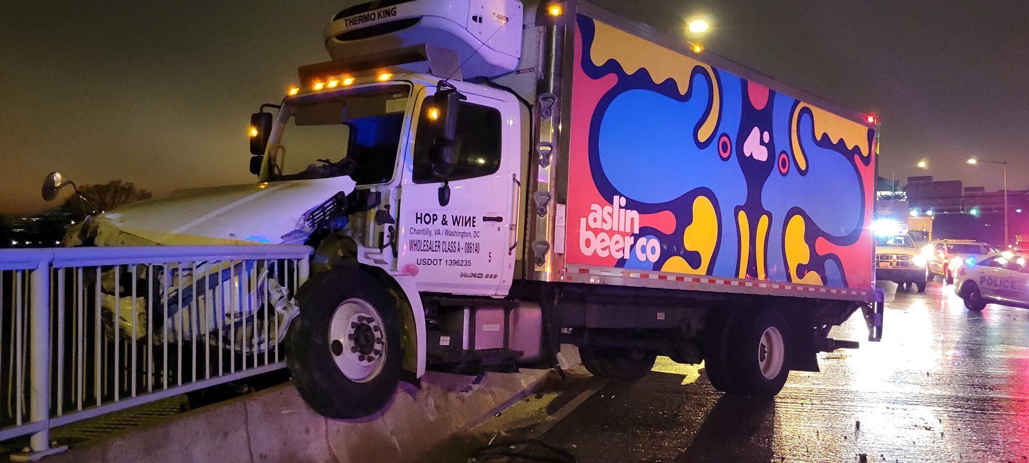
It was the right call. The front came through with lots of blowing and rain and a flicker to the lights. After riding in the basement, I checked the internet. That’s when I learned that around 3 in the morning a beer truck crashed over the Jersey barrier and railing that separates the bike lane from the highway on the 14th Street Bridge. This is on my route to DC.
The cab of the truck made it across the path from the looks of things.
You can’t help but wonder if the beer had fewer hops, this might have been avoided.
The 50 States Ride, the Washington Area Bicyclist Association’s signature event, is my (nearly) annual exercise in self abuse on a bicycle. I’ve done it all but three years since 2006. making this my 13th time. The course is about 60 miles long, weaving through all eight wards of DC so that riders pedal their steeds on the avenues named for all 50 States.
Each year the course is tweaked. This year for the first time that I know of the start of the course was moved from centrally located Adams Morgan to Yards Park in near Southeast DC, on the banks of the Anacostia River. The change moved the first 15 miles of flat terrain to the end of the ride. Yay! Oh, wait.
Starting at Yards Park meant that the first of countless hill climbs came at about one mile into the ride instead of 18 miles. Put on your big boy pants, this is gonna hurt.
And it did. Riding up Martin Luther King Boulevard in Anacostia, I was dropped by my posse – Michael B., Kevin W., Peter K., and Chris M., augmented by Shira and Steve O. piloting tandems with blind stokers. All of these riders are young whippersnappers and I knew I had no hope of keeping up.
After a brief descent from Alabama Avenue and a flat section on Mississippi Avenue we climbed right back up to an even higher point on Alabama. Dropped again. My posse humanely waited for me to catch up. Another flat-ish section was followed by a descent to Texas and another climb back up. Whose idea was this, anyway?
Kelsea (a short-lived addition to the posse) and Kevin (left); WABA’s Colin (with name tag) and Michael B. (in red)
The next 10 miles or so was relatively easy as the route descended to and over the Anacostia to the Hill East and Capitol Hill neighborhoods. Despite its name, Capitol Hill isn’t much of a hill. We rode north through NoMa and into Trinidad past my friend Dave’s ghost bike (a bicycle painted all white as a memorial to and reminder of Dave’s demise from an out-of-control driver in a stolen van).
After a brief pit stop, we began to climb again up aptly named Montana Avenue and up 18th Street Northeast. This long stretch on 18th was designed to put us on busy and traffic crazy South Dakota Avenue for the shortest distance possible. After three quick turns we were headed southwest on busy and traffic crazy Michigan Avenue. We took the lane and rode in a pack which gave us the illusion of safety.
Once past Catholic University we began another climb up bumpy Hawaii Avenue. At this point, Michael left us. He was riding a single speed bike and wisely opted to swap sanity for knee cartilage.
Next up was the Petworth neighborhood. This section was not particularly hilly but involved several turns (and a walk through a farmers market on Colorado Avenue). We headed north to the northern peak of the city. (DC is shaped like a diamond with a bit taken out of its lower left quadrant.) Here we stopped at the Takoma pit stop, home of Mike and Lisa, about whom I can’t say enough nice things. So I won’t.
(No seriously. They do this pit stop thing every year allowing totally sweaty total strangers to use their restrooms and trample their front yards. And they are Nats fans. Lisa maintains a bobblehead shrine. And they ride a tandem that has weird asynchronous pedaling. And Mike has a DC area GPS in his head and knows every street within a 50 mile radius. Also, he laughs at my jokes.)
Lisa and Mike – They’re the pits
After the pit stop we headed to Alaska. As we made the turn back toward the southwest we had our pictures taken by Patti Heck, who does this every year rain or shine. She posts the pix on her Flickr page so check them out. She even got a group picture of my posse. (And an shot of me too.)
We rode down into Rock Creek Park then back up the opposite side into Chevy Chase, home of posh single family homes. We continued working our way south to encounter a climb up Fessenden Street. Somehow I always forget about this monster. Dropped again.
Down and back up to ride Nebraska past American University. Then down a looong way to MacArthur Boulevard in the Palisades neighborhood. Now came the hard part. Up a short, steep stretch on Aspen. Then a reprieve for a mile followed by the longer, steep climb up Garfield Street. When the route started in Adams Morgan this beast came around the 55-mile mark. This year it came around 40 miles when legs were not completely spent. We managed it without much difficulty at all.
Unfortunately, about a mile after a descent from the top of Garfield came Cathedral Avenue, another tough climb my brain had blocked out. Fortunately, there was a water stop at the top of the hill. Unfortunately it was out of water. No worries; all of us had plenty of water to spare on our bikes.
The remainder of the ride took us back across Rock Creek Park to the start of the old route. From there we weaved our way down to downtown on flat streets. During this part someone on a bike yelled out to us. I had no idea who it was but one of my posse recognized the voice. It was Ursula who works for WABA. When we reached the final pit stop at City Center, she re-appeared. She was riding a shorter route with her parents. We chatted a bunch then the posse headed out for the finish. Down to Penn Quarter, over to Union Station, around the Capitol, through Southwest, past the Tidal Basin. We did a 3 1/2 mile loop to Hains Point in East Potomac Park. I had been feeling dead at that last pit stop but adrenaline kicked in and the wind-assisted ride back from the point felt like I was sailing.
The last bit of the ride took us past The Wharf and around Fort McNair. We then did a close pass of the northern end of the brand new Frederick Douglas Bridge, being careful to navigate a construction zone and beaucoup bridge traffic. After a half lap around Nationals Park we arrived at the finish. Knackered and chuffed, we joined the after party where we picked up our t-shirts and shared a victory beer and a slice of pizza.
The things this idiot will do for a t-shirt
As an added bit of pleasantness we were greeted by Jesse, a member of my 2018 50-States posse, and her friend Mike (the two of them housed me at the end of my 2019 tour in San Francisco) and Kitty, a friend who has been living in Brazil for the last few years.
As always, big thanks to all the volunteers (including my friends Monica and Josephine) and to the WABA folks, especially Anna McCormally WABA’s events coordinator, for making this ride a success once again.
Today was perfect riding weather. I rode The Mule to the county recycling center in Lorton, Virginia to dispose of some old motor oil and insecticide. The recycling center is next to the old Lorton Federal Prison and the massive mountain of trash at the county landfill. The prison was closed a few decades ago. The landfill keeps growing.
Yesterday I rode to Fort Washingtonin Maryland, It was a ride that involved several tough hills. Not surprisingly, my legs were not amused by today’s climbs on the way to the recycling station. A couple of the hills reminded me of the long grinding climbs that I did last summer in Colorado, Utah, Nevada, and California. Thankfully, I am near sea level hereabouts so I had no problem with oxygen debt.
I made it in one piece and did my civic duty, pouring about a half gallon of used lawn mower oil into the Vat of Grossness.
The recycling place is on an interesting road.
Maybe they should call the mountain of trash at the landfill Mount Doom.
For the record, Mordor has some of the biggest speed bumps you’ll ever see. They are more like tectonic bulges. You can really get a nice bounce out of them. The giant semis and garbage trucks practically moan when they go over them at 5 miles per hour.
For the record I didn’t call The Mule “My Precious” once.
My reward for a good deed done was the mostly downhill ride back, partly along Old Colchester Road. For about a mile, the roadway, newly paved, descends in a series of curves through a wooded area. 30 miles per hour through a tunnel of fall foliage. Ahhh.
The weatherman is calling for more near perfect weather for the next several days. My legs are going to fall off.
Friday night Jessie and Mike took me to the neighborhood Puerto Rican restaurant In Haight Ashbury and we stuffed ourselves. How do you say gut bomb in Spanish?
Yesterday we took The Mule to Bespoke, a bike shop across town. The owner used to work at my local bike shop in Mt. Vernon. He’ll ship my baby home later this week.
I rode a Jump bike back from the bike shop. It was my first time on an electric assist bike. It’s two-wheeled crack.
We had breakfast al fresco at a restaurant on the Wiggle, a bike route that weaves through the streets of this section of the city, avoiding big hills. It’s painted green and includes a counterflow section.
I bought a massive duffle bag Friday. It had straps on it so I can wear it like a backpack. I could wipe out every passenger on a BART train with this baby. Bwa ha ha.
Last night we had phenomenal tacos at a Mexican place before imbibing a huge bowl of punch at a bar. Not much of an improvement on my bike touring diet I must say but it felt considerably less painful.
I’m staying with Jessie and Mike until Monday morning when the duffle and I will relocate to a hotel near the Oakland airport for Tuesday’s flight home. I’ve already scheduled two happy hours for next week. Unfortunately they are for the same evening.
I looked up some descriptive statistics on the Western Express yesterday. Between Pueblo CO and San Francisco I did more than 98,000 feet of climbing.
And today to prove that this tour has traumatized me, I signed up for my 11th 50 States Ride on Sept 7. Nigel Tufnel would be pleased.
There is an old saying in baseball: you win some, you lose some, and some get rained out.
This is a story about losing, getting rained out, and winning. Leave it to me to get things totally out of sequence.
About two years ago the Red Sox were scheduled to play an exhibition game versus the Nationals at Nationals Park to mark the end of Spring training. I managed to get one of four tickets that one of my co-worker’s bought.
Losing
As I typically do, I set out on by bike for the ballpark. It was raining. I got about five miles from home when, heading northbound, I was hit by a black SUV on the Mount Vernon Trail. (There goes the no hitter.) The SUV was exiting a condominium complex and failed to stop before making a right on red. To this day I am shocked that I managed to escape from this encounter with only some bruises.
Getting Rained Out
A short time after the crash, I was informed by the Twitter that the game was rained out.
Winning
Fast forward 22 months. I am riding southbound on the trail to the exact place where I was hit. There, blocking the entire trail, was a white SUV. I came to a stop and shouted at the driver. “Why are you here? Why are you blocking the trail?” The driver looked at me as if to say “So what.” Then, before I could ride around the front of the vehicle, the driver took off, taking a right turn on red.
I had seen this behavior dozens of times and I finally decided to ask the city of Alexandria to do something about it. I wrote them a short note requesting a change to a sign. Drivers leaving the condo complex at this intersection face a traffic light with a sign that says “No Turn on Red when Pedestrians Are Present.” I asked that the city to replace it with a sign that says “No Turn on Red.” I deliberately kept my request simple thinking it would avoid getting bogged down in analysis and budgetary considerations.
I had no idea that there was an Alexandria City Traffic and Parking Board. My note was referred to them and the issue was placed on the February meeting agenda. My friend Erin Meter provided a statement on behalf of the Friends of Mount Vernon Trail. Her statement, and that of Zack DesJardins, went into details about traffic signal timing, signal delays, best practices on signage and traffic lights and the like. (Judd Lumberjack came and offered moral support.) Erin and Zack did some serious homework on this.
Two representatives of the condo complex spoke. One had several pictures of the scene. (I was half expecting him to talk about the circle and arrows and the paragraph on the back of each one. But I digress.) Finally, I gave a brief statement. (The order was not for dramatic effect. It’s just that I arrived last.)
I explained how I was hit. And that I see the trail obstructed on a regular basis which is obviously dangerous.
The Board then voted unanimously to change the sign and to study the signal and signage issues.
I couldn’t believe it. I actually had to ask Erin if we won.
We won.
A tip of the cap
Many thanks to Christine Mayeur, Alexandria’s Complete Streets Coordinator, for encouraging me to show up and give a statement.
And to Erin, Zack, and Judd for thoughtful statements, support, and photography,
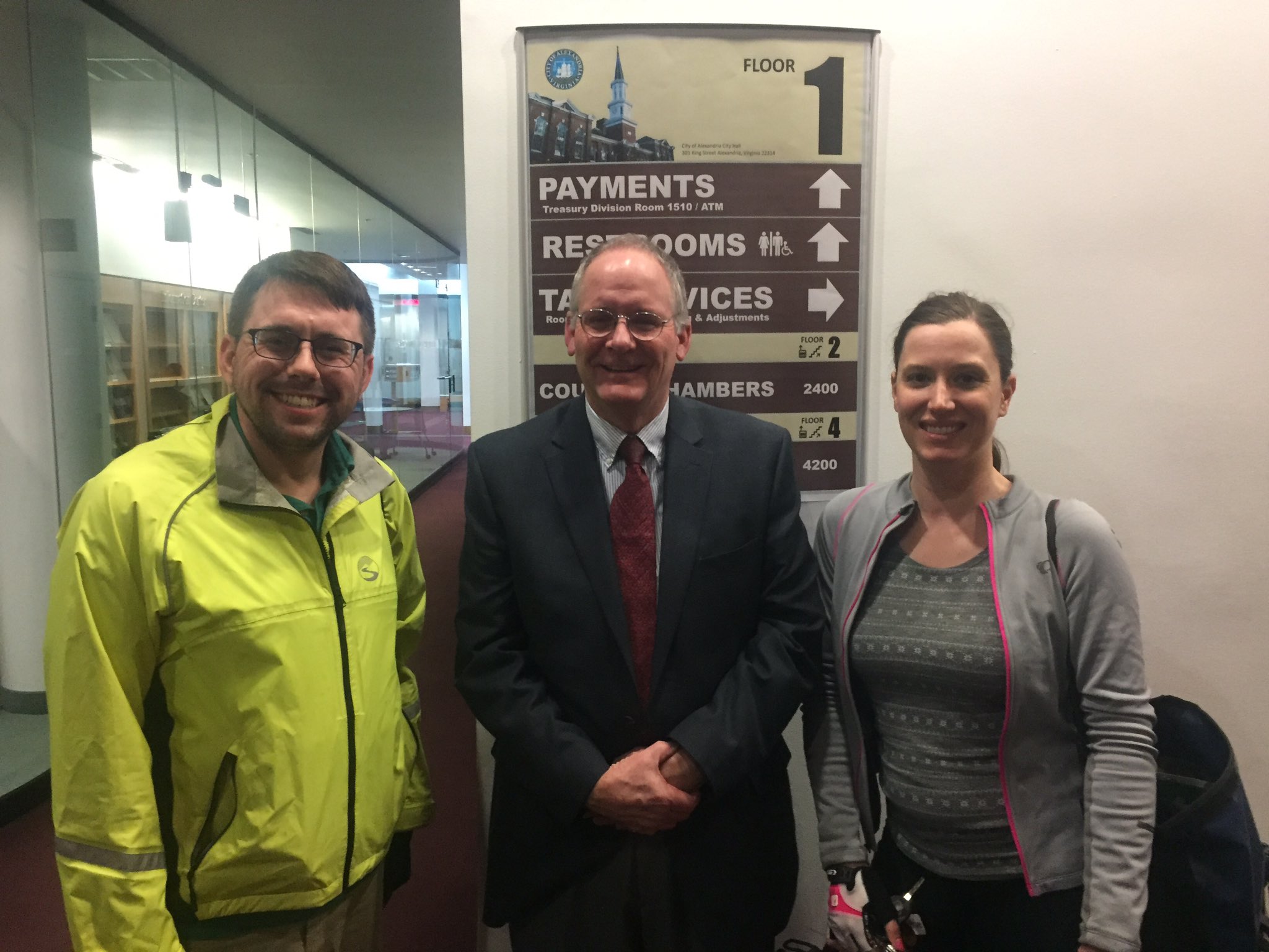
Zack, Me, and Erin (Photo by Judd Lumberjack)
P. S. Teddy Ballgame would not have approved. I put on a tie and nobody died or got married.