Comments on Improving the Mount Vernon Trail and the George Washington Memorial Parkway

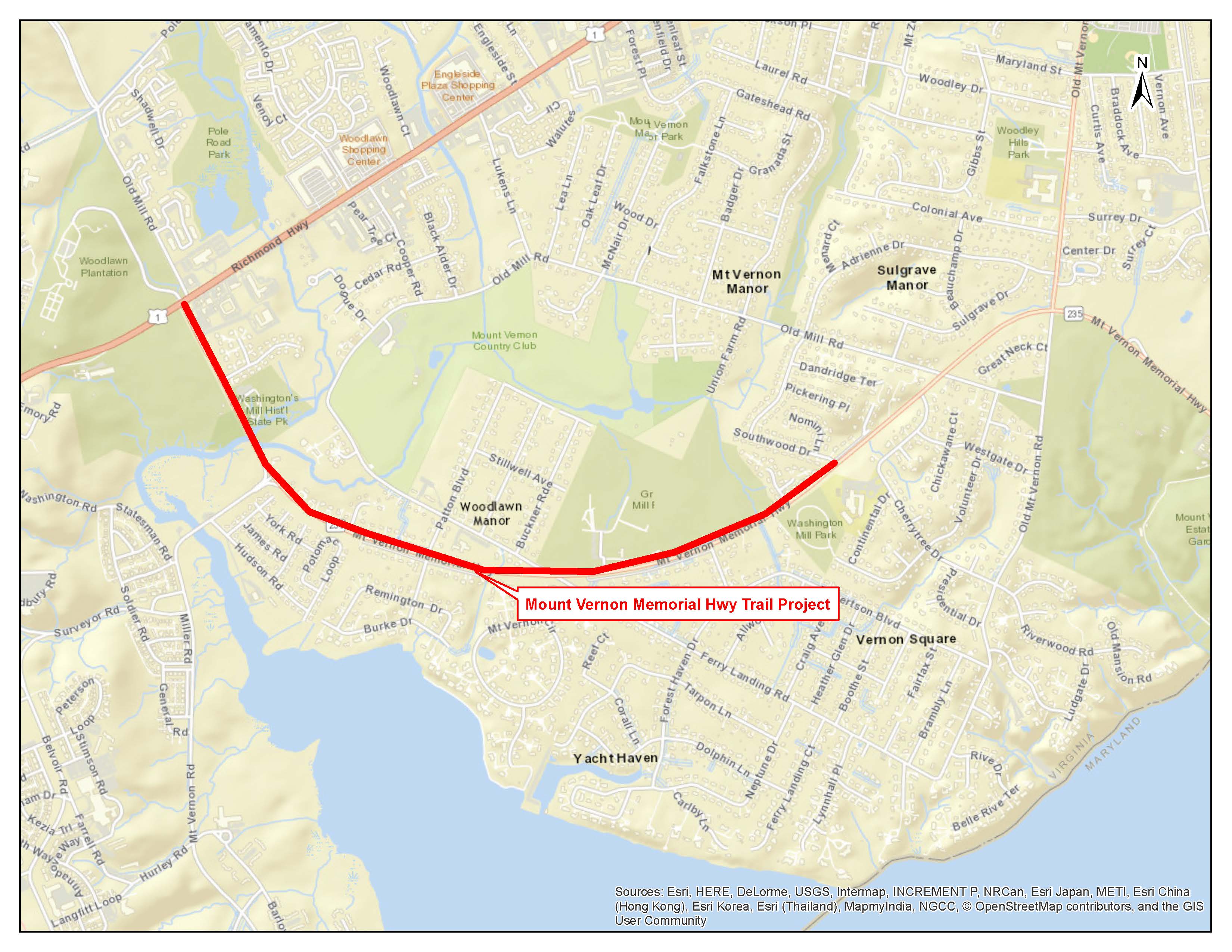
The George Washington Memorial Parkway, despite its name, includes many other facilities besides the roadway. This component of the National Park System is a hodgepodge of disparate things that were thrown together years ago. One of these facilities is the Mount Vernon Trail. Plans are underway to rebuild the Parkway and Trail. Parkway construction upriver from Washington has already begun. The Park Service is taking comments from the public as part of the project’s required environmental assessment (EA). I took the opportunity to provide some. (I subsequently made one more comment that I neglected to save.) A few comments relate to the roadway, most discuss opportunities to improve the trail.

As the comments show, I am not a big fan of the GWMP administration. It’s nothing personal. Like the rest of the National Park System, the GWMP is grossly underfunded and has been for at least a couple of decades. Cutting taxes has its consequences. The problem which I will discuss in a future post go well beyond funding.


I am a 39 year resident of Northern Virginia and a 33 year resident of Mount Vernon. I have logged tens of thousands of miles on the Mount Vernon Trail on my bike. Years ago I also used the trail for running. Before retiring in 2017., I commuted by bike year round from roughly mile 5 to DC and Rosslyn. I am a long time member of the Washington Area Bicyclists Association and the Adventure Cycling Association.

The trail is subject to flooding in the Dyke Marsh area, about 1 mile south of Alexandria. In the area immediately north of the long wooden bridge, the depth of the water already approaches one foot (it came over the top of my hiking boots while I was riding through it on the way to work one morning). You may want to refer to the re-routing of the trail north of Slaters Lane about 25 years ago. Any trail improvements must include raising the trail. At today’s water levels, a few inches is insufficient in Dyke Marsh and many other areas. Future water levels will surely be higher and the trail redesign should take this into account. In addition to the Dyke Marsh area the trail should be raised wherever the trail is in close proximity to the river as it is in spots south of Fort Hunt Park,  in the Daingerfield Island area, on the northbound approach to the Memorial Bridge, and between the Memorial and TR bridges.

The trail needs proper drainage. Especially in the area north of Northdown Road. The trail in this area is subject to stretches of black ice in winter. In the short term this area would benefit from signage that warns users of icy conditions on the trail. (The current signage only refers to bridges.)

The trail needs to be level, except where curves in the trail require otherwise.  In many places the trail is canted toward the river, presumably to provide drainage. The slant in the trail causes inexperienced riders to veer off the trail and is particularly hard on runners’ knees.

The 2020 NPS report on the trail did not properly consider trail use during non-daylight hours. There are numerous areas where southbound nighttime riders are blinded by the headlights of northbound vehicles on the Parkway including along the pinch spot near the auxiliary runway at DCA, at the oxbow at Daingerfield Island, and at the southern most point of the Four Mile Run bridge. I have nearly hit other trail users because of this and have witnessed collisions. This is a BIG problem for commuters. In the short term, inexpensive remedies such as snow fences or other barriers such as bushes should be installed.

The trail surface needs to be treated in winter. Just like the Parkway. Trail users can’t safely commute on ice and snow anymore than drivers can.

Light use of the trail in Fairfax County is not a reason to delay the renovation of the trail. Light use is a consequence of neglected maintenance and the shoddy condition of the trail. 

The trail is part of several long distance bicycle touring routes.There is no viable alternative to the Mount Vernon Trail for north-south bicycle tourists in the DC area. Bike tourists (and others) have complained to me that the condition of the trail is so bad that they asked me for alternatives. One southbound tourist I talked with was even considering riding south on US1 in Fairfax County.The extensive damage to the trail south of the Beltway constitutes an unsafe condition for park visitors and needs immediate attention. I have advised Adventure Cycling of the trail conditions so they may warn their members.

Most of the bridges on the trail are made of wood. Other surfaces need to be considered. A particular shortcoming is the fact that the wooden bridges cannot support emergency vehicles or maintenance vehicles such as those used to plow snow or spread surface treatments in winter. To avoid damage to a wooden bridge. I once guided an ambulance carrying a crash victim in reverse about 1/4 mile up the trail to Northdown Road. At a minimum the Park Service should establish access points for emergency responders so that this doesn’t happen.

The trail now functions (if it didn’t already in the past) as a fifth lane of the GW Parkway and should be maintained, operated, and funded as such in the future. When the Parkway incurs damage that is dangerous to motorists, the damage is repaired and removed promptly. This hasn’t been the case with the trail for many years. Contracts for trail storm damage remediation should be in place year round. For example, there is extensive trail damage between Alexandria Ave and Tulane Drive. A massive root ball and  tree trunk have obstructed the trail since late 2020 (or earlier). The damage worsened after a January 2022 storm. obstructing the trail. One half of the trail is obstructed. (Would you allow a lane on the Parkway to be in this condition for this long? Bridge 19 was damaged by a fallen tree in January 2022. It is missing a section of railing and two other sections of railing were damaged. The Park Service should at least install some yellow safety tape to alert trail users of the hazard.) And there is extensive washboard from root heaves and potholes from one end of the trail to the other. 

Over a decade ago the Park Service considered building a bypass at Gravelly Point. For visitor safety, the bypass obviously is needed and should be built as part of this project. The airplane viewing area is one of the busiest parts of the trail and a permanent restroom facility is needed here. Porta potties are inconsistent with the aesthetics of the GWMP. 

Much of the routine maintenance of the trail is now performed by volunteers, many of whom are affiliated with The Friends of the Mount Vernon Trail. For all their hard work, the Friends provide only one full time equivalent worker each year to trail maintenance. The Park Service doesn’t even fund their equipment. This is not nearly enough. Much of the work they do used to be performed by park employees and landscape contractors. Unlike DC, we have no Trail Rangers on this side of the river. In the short term the Park Service should amend its landscape contracts to require edging of the trail. (The contractors currently do this on the loop road in Fort Hunt Park.)

Recent re-striping of the Parkway between Tulane Drive and Morningside Lane runs along the right side of the roadway. In the area leading up to Morningside, this section of the road floods on a regular basis. In winter this often turns into thick ice. The striping should be moved to the left lane (as it is at Alexandria Avenue) for safety.

Turning north onto the Parkway at Morningside Lane is inherently dangerous. Absent installing a traffic light, I recommend eliminating this turn.

The situation at Belle Haven Road and Belle View Boulevard cries out for much more than some paint, stop signs, and flexposts. Unless legislation specifically prohibits them, traffic lights should be installed. Absent that, traffic circles of the type used on nearby Oxon Hill Road south of the outlet mall should be considered. 

At-grade crossings for bicyclists and pedestrians are not likely to succeed. Build a bike/ped overpass that connects to the trail. Even an at-grade crossing should have a paved connection to the trail. And flashing lights that are passively activated such as at the northbound Parkway approach to the Memorial Bridge should be included in the design.

The entrances to the trail at Daingerfield Island and Belle Haven Marina merit stop signs for motorists. Trail users’ safety should take precedence over motorists’ convenience. (I was hit by a car on the trail at Porto Vecchio condominium a few years ago. After I presented testimony at a city meeting, the city changed the signage and traffic light sequence.) 

Oxbows such as the one at the old Bridge 12 location near Fort Hunt Park are inherently dangerous. The similar trail configuration at Bridge 1 should be removed as part of the rebuilt trail. I crashed there and my injuries resulted in a visit to the Mount Vernon Hospital emergency room. My bicycle was ruined. This bridge and the approach from Mount Vernon replaced an even more dangerous original design. Clearly, half measures are not enough to ensure public safety. Another oxbow exists at Daingerfield Island. This one does not involve a bridge but I have witnessed far too many crashes and near misses as south-bound bicyclists come downhill into a sharp curve. A simple solution is to make the approaches gradual. This would also bypass the area of flooding immediately south of the oxbow.

In general, changes to the road and trail that improve visitor safety are in the public interest and should be given precedence over aesthetics. 

Thank you for the opportunity to comment on this project. Feel free to contact me for clarification of any of these points.


There and back again

Today was perfect riding weather. I rode The Mule to the county recycling center in Lorton, Virginia to dispose of some old motor oil and insecticide. The recycling center is next to the old Lorton Federal Prison and the massive mountain of trash at the county landfill. The prison was closed a few decades ago. The landfill keeps growing.

Yesterday I rode to Fort Washingtonin Maryland, It was a ride that involved several tough hills. Not surprisingly, my legs were not amused by today’s climbs on the way to the recycling station. A couple of the hills reminded me of the long grinding climbs that I did last summer in Colorado, Utah, Nevada, and California. Thankfully, I am near sea level hereabouts so I had no problem with oxygen debt.

I made it in one piece and did my civic duty, pouring about a half gallon of used lawn mower oil into the Vat of Grossness.

The recycling place is on an interesting road.

Maybe they should call the mountain of trash at the landfill Mount Doom.

For the record, Mordor has some of the biggest speed bumps you’ll ever see. They are more like tectonic bulges. You can really get a nice bounce out of them. The giant semis and garbage trucks practically moan when they go over them at 5 miles per hour.

For the record I didn’t call The Mule “My Precious” once.

My reward for a good deed done was the mostly downhill ride back, partly along Old Colchester Road. For about a mile, the roadway, newly paved, descends in a series of curves through a wooded area. 30 miles per hour through a tunnel of fall foliage. Ahhh.

The weatherman is calling for more near perfect weather for the next several days. My legs are going to fall off.

Emilia and the Red Caboose

Yetserday, I rode the Great Pumpkin Ride in Fauquier County, Virginia with my friend Emilia. This was our fourth ride together. Our first ride together was the 2014 50 States Ride. She had a rough time. We did it again in 2017 and this time I had a rough time and she, despite missing several climbing gears, flew up the hills. She weighs about half what I do so it was reasonable to assume would bury my sorry old ass on a sod farm in the hilly Virginia Piedmont.

Lucky for me, the last ride she did was the New York City Century back in early September. Unlike me she skipped breakfast. So on an empty stomach and with legs that hadn’t spun a pedal in seven weeks, she insisted on riding the long, 67-mile route yesterday. She’s pretty tough.

We lined up next to the red caboose at the start/finish line. Soon we were off down a rail trail then onto country roads where we were treated to rolling hills, 60 degrees, calm winds, cloudy skies, and the occasional sprinkle as we cruised through the rolling terrain at between 12 and 13 miles per hour. The foliage was close to peak and every so often we oohed and aahed at natures show. The lifestock in the fields seemed utterly (pun intended) uninterested in our passing. I explained that during my ride across the northern plains last year, I could get cattle and horses to stampede. Their Virginia cousins were having nothing of it.

The police warned us not to ride side by side so Emilia followed close behind me for most of the ride. She rides a bit closer to the edge of the road than I prefer so there was little chance that we’d overlap wheels.

Emilia’s native language is Spanish. I take advantage by quizzing her about useful phrases that I typically forget. Mostly we just rode and listened to the voices inside our heads. It’s nice to have a riding partner who appreciates that.

IMG_3277
Just trees and hills and fresh air


Thanks to her layoff, we rode at exactly the same pace for nearly the entire ride. She’s a vegetarian and needed no prodding when we came to the first rest stop 19 miles into the ride. There she gorged herself on a thin slice of cinnamon bread and half of a banana. I noticed she had barely touched her water bottle. I thought “no bueno” but she was perfectly happy with her food and water intake.


We rode another 22 hilly miles before finding the next rest stop.  She was laboring a bit at this point so she gorged herself with a thin slice of pumpkin pie and a wee bag of potato chips. Then off we went.

IMG_3282 (1)
Emilia after pumpkin pie

The next thirteen miles were a bit hillier. I noticed at mile 50 she was laboring up a hill. Her thigh muscles were cramping. Her water bottle remained nearly untouched. No bueno. We slowed a bit and forged ahead. At an intersection with a busy highway she had trouble unclipping from her pedals and wobbled into the cross road. Fortunately no cars were coming but she knew that the little incident could have been bad news. I could see on her face that the layoff since early September was taking its toll. She was pretty tired.

The route to the final rest stop is out-and-back for about 2 1/2 miles. We saw riders returning from the rest stop turning toward the finish. Emilia did not have a cue sheet in front of her and got rather animated about following them. I briefly considered skipping the rest stop. That would have risked seeing her bonk all the way to the finish so I explained we needed to get some food in her and forged ahead to the rest stop at the Old Bust Head brewery.

Once there, she had pie, three small cheese quesadillas, a small portion of tater tots, a cup of pumpkin soup, and two cups of Gatorade. Smiles.

“Ok, John, I’m ready.”

Crisis averted. As we rode I counted down the next few miles.

12!

11!

Only tell me the single digits.

How do you say nine in Spanish?

Nieve!

Ocho!

She fell back on a hill, caught up, then fell back again.

Are we at seven?

No. Cinco!

You’re kidding.

No.

Big smile.

A few more hills and we found ourselves on the rail trail back into town. It always seems longer that it actually is. Emilia started looking for the caboose.

And there it was after 67 hilly miles.

IMG_3284 (2)
Emilia, her steed, and the caboose

Tired but todo sonrisas.

We hope to ride again next Saturday at the shorter and flatter Cider Ride in DC. There will be no caboose but the donuts and cider and pie will make up for it.

And some don’t get rained out

There is an old saying in baseball: you win some, you lose some, and some get rained out.

This is a story about losing, getting rained out, and winning. Leave it to me to get things totally out of sequence.

About two years ago the Red Sox were scheduled to play an exhibition game versus the Nationals at Nationals Park to mark the end of Spring training. I managed to get one of four tickets that one of my co-worker’s bought.

Losing

As I typically do, I set out on by bike for the ballpark. It was raining. I got about five miles from home when, heading northbound, I was hit by a black SUV on the Mount Vernon Trail. (There goes the no hitter.) The SUV was exiting a condominium complex and failed to stop before making a right on red. To this day I am shocked that I managed to escape from this encounter with only some bruises.

Getting Rained Out

A short time after the crash, I was informed by the Twitter that the game was rained out.

Winning

Fast forward 22 months. I am riding southbound on the trail to the exact place where I was hit. There, blocking the entire trail, was a white SUV. I came to a stop and shouted at the driver. “Why are you here? Why are you blocking the trail?” The driver looked at me as if to say “So what.” Then, before I could ride around the front of the vehicle, the driver took off, taking a right turn on red.

I had seen this behavior dozens of times and I finally decided to ask the city of Alexandria to do something about it. I wrote them a short note requesting a change to a sign. Drivers leaving the condo complex at this intersection face a traffic light with a sign that says “No Turn on Red when Pedestrians Are Present.” I asked that the city to replace it with a sign that says “No Turn on Red.” I deliberately kept my request simple thinking it would avoid getting bogged down in analysis and budgetary considerations.

I had no idea that there was an Alexandria City Traffic and Parking Board. My note was referred to them and the issue was placed on the February meeting agenda. My friend Erin Meter provided a statement on behalf of the Friends of Mount Vernon Trail. Her statement, and that of Zack DesJardins, went into details about traffic signal timing, signal delays, best practices on signage and traffic lights and the like. (Judd Lumberjack came and offered moral support.) Erin and Zack did some serious homework on this.

Two representatives of the condo complex spoke. One had several pictures of the scene. (I was half expecting him to talk about the circle and arrows and the paragraph on the back of each one. But I digress.) Finally, I gave a brief statement. (The order was not for dramatic effect. It’s just that I arrived last.)

I explained how I was hit. And that I see the trail obstructed on a regular basis which is obviously dangerous.

The Board then voted unanimously to change the sign and to study the signal and signage issues.

I couldn’t believe it. I actually had to ask Erin if we won.

We won.

A tip of the cap

Many thanks to Christine Mayeur, Alexandria’s Complete Streets Coordinator, for encouraging me to show up and give a statement.

And to Erin, Zack, and Judd for thoughtful statements, support, and photography,

Zack, Me, and Erin (Photo by Judd Lumberjack)

P. S. Teddy Ballgame would not have approved. I put on a tie and nobody died or got married.


Connecting and Extending the Mount Vernon Trail

The Mount Vernon Trail, a facility of the National Park Service, is well known to cyclists, runners, and walkers in the DC area. It extends from Theodore Roosevelt Island in the north to George Washington’s Mount Vernon Estate in the south. Beyond Mount Vernon, there are trails of a sort but they come and go for three miles along the two-lane Mount Vernon Memorial Highway to US 1 where new trails continue south down through Fort Belvoir. (The mega re-design of US 1 to the north of Fort Belvoir will include separated bike lanes. ) The Fairfax County Department of Transportation is planning to connect the existing trail segments along the MVMH to provide a continuous trail that connects Mount Vernon to US 1.

Last night I attended the first public meeting about this project. It was run by Chris Wells, the Fairfax County Bicycle and Pedestrian Coordinator with significant additional remarks by Dan Storck, the Mount Vernon District Supervisor.

Beyond its local significance the Mount Vernon Trail is part of other much longer trail systems, including the Adventure Cycling Association’s Atlantic Coast Route, the East Coast Greenway, and the Potomac Heritage National Scenic Trail.

The project is an admirable one, but it has significant shortcomings.

The Mount Vernon Trail itself stops at the southern end of a parking lot. To continue south cyclists have two options. They can walk the sidewalk in front of the entrance to Mount Vernon or ride (illegally) on the George Washington Memorial Highway for a few hundred yards. Neither of these shortcomings is addressed in this project.

The GW Parkway ends at Mount Vernon. To continue south, travelers use the MVMH. At this point a new-ish side path exists for about 1/2 mile to a traffic light at Old Mount Vernon Road. After the light, there is an old, narrow asphalt path that is in lousy shape with tree roots and debris. After a few hundred yards that path ends and path users need to cross the MVMH to get to another similarly decrepit path along the MVMH. This path has the added feature of a series of abrupt ups and downs. This path segment ends after about 1/4 mile at Southwood Drive. Local residents report that these three parts of the trail are virtually impossible to ride on a bike and in such poor condition that even running is problematic. Unfortunately, improvements to or realignment of these side paths are not included in the project scope.

The first of the proposed new segments would begin on the opposite side of the MVMH from this last bit of path. It would continue only a few hundred yards to another existing side path that extends from Peartree Landing (a neighborhood street) to the entrance to Grist Mill Park, which contains soccer fields, a large playground, and the area’s free mulch collection. This existing segment is wider and newer than the others describe above. Nevertheless, the local residents I talked with said this segment also has problems with tree roots.

Beyond Grist Mill Park a new trail segment is planned that will cross the southern end of Old Mill Road until it reconnects with a little used, existing frontage road. After the frontage road, the new trail will begin again and cross Dogue Creek on a new steel and concrete bridge.

After Washington’s Grist Mill, the new trail segments will end. Those wishing to continue south on a trail will have to re-cross the MVMH to connect with a new existing trail that continues a couple of hundred yards to US 1.

The project plans include wayfaring signs, as well as improved crosswalks and bus stops.

The project team’s consultants were in attendance. Maps of the project were on easels for review. There were about 40 – 50 people in attendance. Considering the fact that this was a preliminary meeting, this was an impressive turnout. Attendees included people who live along the project corridor and others, like me, who use the corridor for cycling.

Concerns raised included:

  • The design of the Dogue Creek bridge. It will be steel and concrete which will hopefully lessen the crashes that are endemic to the Mount Vernon Trail’s wooden bridges.
  • Crossing the MVMH is dangerous now. Recently, a 15-year old runner was hit by two cars as she crossed the road. (She lived but is in for a long recovery.) Attendees asked for traffic signals of some sort and consideration of sight lines when positioning cross walks.
  • Local residents say that traffic has increased significantly since the military base re-alignment moved thousands of personnel to Fort Belvoir. The residents say that the 45 miles-per-hour speed limit is too high considering the highway traverses a residential area. This is clearly one of those places were Virginia DOT prioritizes moving commuters over residential users.
  • Local residents also decried the condition of the decrepit existing trail segments.
  • The crossing at Old Mill Road is a potential problem. Local residents cut through a neighborhood and a wooded perimeter area to access the park now to avoid this intersection.
  • Drainage is a problem now for one resident whose home abuts a new trail segment.
  • The trail right of way could be 20 to 30+ feet depending on the type of drainage used at the highway’s edge. One resident noted that his driveway is only 40 feet long.
  • Residents clearly would prefer to limit the trail to one side of the highway.
  • Trees will have to be removed to accommodate the new trail assuming it stays in its current alignment.

The next step is for the project team to do a detailed analysis of the corridor and produce a preliminary design for public comment. That process will take six to nine months.

As readers of this blog know, I do not much enjoy doing bike advocacy work, but I have to say that this meeting was actually fun. There was concern without anxiety on the parts of the attendees. I think they had plenty of time to have their say. Chris Wells and Dan Storck did a great job of listening and making thoughtful observations. Project team members and Dan Storck were taking notes. With projects like these the old saying “The devil’s in the details” holds.

As for me, I was encouraged to see that Chris has picked up where Adam Lind (currently cavorting in Santiago, Chile) left off as Bike/Ped coordinator. This was my first interaction with Dan Storck. My district supervisor is an avid cyclist. Obviously, he has to take into consideration all users and constituents but it is a great relief to know that he speaks my language.

As for me, I doubt I will use the new trail. I don’t use any of the existing trails segments. I am comfortable in the road, but I understand that others, most importantly the people in the adjacent neighborhoods, are not. I also doubt bicycle tourists, experienced recreational riders, and commuters will want to meander back and forth across the highway. However, the project clearly addresses many existing shortcomings for walkers and runners and less experienced cyclists.

Finally, I did get a chance to talk to Dan Storck about his annual Tour of Mount Vernon bike ride. When I first heard about it, I thought is was a dinky neighborhood ride. Wrong. It’s the real deal at 36 miles and he’s very excited that it’s catching on after only a couple of years. I didn’t ride it last year because I was already committed to WABA’s 4th Annual Cider Ride. Hopefully, this year WABA and Supervisor Storck can coordinate dates so I can do both.


Three Errands in One Day

Thannk god for the Errandonnee. I don’t have to think of ideas for blog posts for 12 days.

Today’s first errand, such as it is, was another ride to and from work. I wasoperating on 5 1/2 hours sleep this morning and switched my fuel to Eggos for a pre-launch sugar spike. The temperature was in the high 40s so I ditched the winter gear and went with shorts. SHORTS!!! I froze for the first five miles but it was so worth it.

Digression: I neglected to mention that on my ride home last night I heard my first spring peepers of the year at the southern edge of Old Town Alexandria.

Anyway. SPRING!!!

I stopped to look at a sign from the National Park Service. They run many parks in the DC area. Local cyclecross enthusiasts have been using an area alongside the Mount Vernon Trail for training. You know, having fun. Can’t have that, says the grumpy Park Service.


On the way home, I stopped by the bank to use the magic money machine. (I once heard a father tell his toddler that he was using the magic money machine. The poor kid was probably seriously disappointed when he found out the truth.)

A bit further along I stopped at the bike shop to have my shifter serviced. Taylor the Mechanic tried but the replacement part didn’t work so I had to order a new set of shifters.

Three errands in one day, lying in the depths of your Errandonnation. (A free pint to the reader who has a bloody clue what that line was about.)

Errand No. 6

Category: Work (2nd use of this category)

Miles: 29 1/2

Observation: Actually made by #bikedc’s Shawn: The Park Service is always saying it has no money, so where does it find the funds to buy signs prohibiting enjoyment of their parks?

Errand No. 725506598392_d8a41c323c_m

Category: Personal Business (Bank)

Miles: -1/4 (I short cut from my route through Jones Point Park)

Observation: ATMs would be more fun if they really were magic. Maybe they’d emit a cloud of smoke like a magic trick when they dispensed cash.


Errand No. 825330101180_e98ec2d8d4_m

Category: Store (Bike Shop) 2nd use of this category.

Miles:  3/4 (A diversion from the MVT to Belle View Shopping Center via the US 1 connector trail.)

Observation: It was in the 70s today so I was shocked when there was no line at the service desk at the bike shop. Also, you have to love a bike shop that will do minor service on your bike while you wait. Spokes Etc. is terrific for this.


Bike, Wash, and Drink, Oh My!!!

We were under a tornado watch. A long north/south line of intense storms, about 10 miles wide and a hundred miles long (both guesses), was tracking to the north. From the animation on the weather sites, it was clear that no matter what I did, short of staying at the office until 8 or 9, I was going to have to ride through this beast.

The good news was that it was warm out. Over 60 degrees. The first half of my commute was into a strong and gusting headwind but it was toasty. Then, at the 7 1/2 mile mark near the power plant in Alexandria flashes of lightning started. Not cloud to ground but bright enough to get my attention. Old Town passed without incident. Light rain, with big drops, started to fall. As I approached the Wilson Bridge I caught a glimpse of the sky to the west. NASTY. Dark. Reddish. Eek.

The wind now changed direction. It blew me up the ramp to Washington Street. Then I turned left to head down the trail. Oof! Gusts from my left pushed me toward the street to my right. I tucked and pedaled hard to maintain my forward momentum. More gusts. Stronger. More lightning. Then the rain began. Moderate but blowing every which way. The water was cold but the air was warm so my wool clad feet stayed comfortable.

More lightning. Thunder. Every time the trail took me behind brush or trees the force of the wind gusts diminished. As I cleared the trail at Northdown Road the skies opened. I opened my mouth and it was as if I was drinking from a glass. I couldn’t see ANYTHING. So I navigated on instinct having ridden this road hundreds of times. Standing water was several inches deep. A torrent came down the little hill from the stone bridge.

I crested the hill and crossed the bridge and damned it the rain didn’t intensify. This was INSANE! And sooooo much fun. I took the lane mostly because about four feet at the edge of the road had four inches of water rushing along it.

I barely made my turn on Shenandoah Drive. Brakes are not real useful in this sort of deluge. I tried to keep an eye out for debris in the road. It was hopeless. I had all I could do to stay ON the road.

I lucked out when a car pulled in front of me and activated the traffic light at Fort Hunt Road. I blasted across and kept riding. Cars were giving me plenty of room. A mile from home an intense blast of lightning, then, a second later, a bone shaking blast of thunder filled the sky.

Woot!

Pedal, pedal!!!!

I had to come to a stop to make the turn on Collingwood Road a quarter mile from home. I let five cars go by so that I wouldn’t have to worry about them running me over in the blinding rain.

After 15 miles, I pulled into the yard.

If I had driven, this commute would have sucked. On my bike it was a thrill.

We should have tornado watches more often.

Post Script: This is apparently what I rode through after it tracked east about 15 miles. Dang!

Triple Play for Punxatawney Phil

As every American knows, Punxatawney Phil is a groundhog who comes out of his hole on Groundhog Day (dang, isn’t that clever). If he sees his shadow, there will be six more weeks of winter. If not, liberation! Lord only knows how this myth got started.

At least Phil isn’t as politically dubious as Indian summer.

So today was the first, honest to god springlike day of the year. It took about six hours of daylight to get going in earnest, but temperatures eventually rose into the high 60s.

I started the day warming up for Errandonnee 2016. This was once called the Utilitaire, a name I prefer only to annoy the Goddess of Errands.  Whatever it’s called, it’s all about doing errands by bike. Today, I took my neglected recumbent, Big Nellie, out for some chores. Our first stop was the dry cleaners. I could use a dry cleaner in our office building but I like the people who run the shop near my house. You have to support nice people. Even if their shop is on US 1 in Fairfax County. Not to put to fine a point on it, US 1 is an abomination. It sucks in every conceivable way. And it’s even worse if you are on a bike. If you don’t support nice people, you get not nice people. Nice people are more better.

Next stop was the clothes donation bin. This was on the opposite side of US 1 so I got to play with cars. None of them hit me.

I crossed back over US 1 and made for the local hardware store. The clothes donation bin was 100 yards from a Home Depot. The hardware store is run by nice people (one of the owners rides a bike up and down the Mount Vernon Trail in the mornings). They sell all sorts of useful stuff. Until you buy a house you probably don’t shop at hardware stores. For homeowners, hardware stores are like a toy store. They are filled with all sorts of interesting stuff. Ours sells 25 pound bags of shelled bird seed covered with cayenne pepper. It’s expensive but the squirrels don’t like it and the birds do. I bought a bag and dropped it in my old pannier. The ride home was a bit lopsided but Big Nellie was up to the task.

With the Errandonnee practice run complete, I turned my attention to my bete noire: Not the Bryan Ferry record, squeaky brakes. According to Google, “squeeky brakes” is
“freins grinçants” en Francais. Why didn’t I learn this in 4 1/2 years of studying French?

First I worked on Big Nellie’s back brakes. This involves putting this huge bike in a bike workstand, adjusting the brakes, taking the bike out of the stand, going for a test ride and repeating. All the while dropping F bombs, because you really need three hands and I only have two. (If we survive climate change, humans will sprout a retractable third hand from their appendixes. And I bet  you thought it was a useless vestigial organ.)

It took me only two tries and about 20 F bombs but I silenced the squeal.

Next I put The Mule in the stand and went at it. The brakes on Big Nellie are V-brakes. The brakes on The Mule are cantilevers. The adjustment is the same but you need an additional tool (a wrench) to work on cantilevers. This ups the f-bomb count substantially. Fortunately, The Mule isn’t as ungainly as Big Nellie so it’s easier to get into the stand. After about 15 minutes I had silenced the truly irritating screech from both front and rear brakes.

After a quick lunch, I hopped on Big Nellie for a reward ride. I rode over to the Mount Vernon Trail which was busy with families. Many of them had free range toddlers. If you want to identify suboptimal parents, just go to the busiest trail in the mid Atlantic on a warm, sunny day and look for the ones with free range toddlers. As a reformed suboptimal parent, I sympathize and ride especially carefully around these people. There are also the our-kid-got-a-bike-for-Christmas-let’s-go-get-them-killed parents. I know its a “bike path” but it’s got MAMILs and teenagers on it and your kid can’t ride in a straight line yet. DON’T BRING THEM TO A TRAIL!!! Sorry. Life’s not fair. (You can trust Scar on this.)

After a ride across the Woodrow Wilson Bridge sidepath which was filled with British sympathizers (they all seemed to walk on the left today), I rode down into Jones Point Park. Here I saw several optimal parents. They were teaching their kids to ride their bikes off the trail in the big paved area under the bridge. If you have a kid who’s learning to ride a bike TAKE THEM TO JONES POINT PARK. It even has nice bathrooms. And a rudder from a World War I ship.

I rode through Old Town to Four Mile Run, then came back through Del Ray. People were out and about. Cabin fever was being cured. Smiles abounded.

I took the Park Terrace hill on the way home. Riding hills on a recumbent is not big fun, but I needed a challenge. The grind put me in a trance and somehow I found myself riding over the crest of the hill.

So there you have it. Errands, Bike maintenance. Lazy ride.

A triple play on a sunny day.

Thanks Phil. See you in about three weeks.


IWBTWD – Catchy, no?

Today was International Winter Bike to Work Day. I think it’s really for some sort of demented  bragging rights. Also for stupidly long hashtagging. Actually, it’s International Northern Hemisphere Winter Bike to Work Day because what’s the point of bragging about riding to work in Perth when it’s 80 degrees outside.

Yesterday was a telework day. The only bike related thing I did all day was to attend a 24966240255_e9de876daa_mWABA happy hour. This was 2 miles from my office which would have been easy to ride to had I not been teleworking. I drove instead because there isn’t a whole lot happy about riding a bike 17 miles in the freezing cold, having a beer, and riding the bike 17 miles in the freezing colder. Bike to happy hour is best done in the summer when you can have a beer outdoors while Colin Powell poses for a picture nearby.
24349241193_d3430eb2c2_m

This morning the thermometer read 22. I was prepared to wear tights under my bike shorts under my rain pants. The lack of wind convinced me to downgrade the tights to wicking briefs (that is underpants made of non-cotton farbic). In a mile I knew I had nailed my winter biking attire. I was perfectly comfortable all the way to Friday Coffee Club. Along the way I stopped to admire the heavenly smile of daybreak at Dyke Marsh.

I was intent on getting to Coffee Club with time enough to enjoy myself. I rode as fast as my three layers of clothing with hiking boots and 25 pounds of pannier stuff would allow. I focused on my pedaling and breathing which pretty much put me in the trance mode for several miles.

Along the way my front wheel acted up. Every time I hit my front brake, the brake would bite the rim once during each wheel revolution. I couldn’t find a bump in the rim but this was not a good development.

I made it by 8:05 and could take my time conversing. Felkerino managed to inadvertently flip a saucer into the air where it knocked over my water glass sending ice water onto my head gear. It was a stunt that would have made Rube Goldberg proud. My buff – which covers my face in winter – was wet but I managed to get everything else out of harm’s way. Need less to say, the two mile, buffless ride to the office was eye opening.

During the day I managed to dry my buff (now doesn’t that sound interesting?) so I was all set to ride home. The ride home featured a headwind which was a bit annoying. My brake problem was not annoying because it had disappeared. Also not annoying was the fact that I rode more than halfway home without turning my headlight on.

Hurry spring.


The No Squish Bike Commute

It’s astonishing how much more comfortable bike commuting can be when your boots are not filled wit24309316603_3da4d74d9c_mh ice cold Potomac River water.

And so today’s bike commute into a cold headwind was rather nice. I stopped for a sunrise picture made less risey by the fact that I left late and the sun is coming up earlier.

The wooden bridges on the Mount Vernon Trail had a slight coating of ice, which is to be expected when it is near freezing. It turns out those road signs are right: bridges do freeze before roadways. Who knew?

I know of one person who knows. The worst of the ice was on the Trollheim, the boardwalk beneath the Teddy Roosevelt Bridge about 1/2 mile from my office. Legend has it that a troll lives beneath the boardwalk and, on cold or wet days, the troll reaches up and grabs bike commuters causing them to crash. I was making my way gingerly across the icy boards when I spotted a big smush mark in the ever so thin dusting of snow on top of the boards to my left. This is a sure sign that a bike went down.

The ride home was a blustery affair. I had a tailwind most of the way. Every so often the wind would abruptly change direction and slap me upside the face. Wake up, dude! I even caught a 20 mile per hour gust broadside that nearly knock me off the trail.

Tomorrow I work from home so I will miss out on one of the COLDEST DAYS OF THE YEAR!!! Actually by the standards of where I lived for the first 28 years of my life, these “brutally cold” days are pretty much the winter norm. Everything is relative. Except ice cold river water in your shoes, of course. That absolutely sucks.