June by the Numbers

In June I rode 29 of 30 days for a total of 2,260.5 miles all in The Mule, my Specialized Sequoia touring bike. My longest ride was 136 miles from Fargo to Gackle, North Dakota. And The Mule broke both the 47,000 and 48,000 mike marks.

In the first half of 2018 I rode 6,254 miles.

Any Road Tour: Day 33 – Headwinds to Circle

Last night I learned that Wibaux has its own microbrewery and it serves pizza. I walked into town to partake. The pizza was very small but delicious. I decided that in lieu of dessert I would have another beer. It was muy bueno.

So if you’re ever in Wibaux try the Pale Ale.

After a sumptuous breakfast of Froot Loops and toast I hit the road for the 30 mile ride to Glendive. The first 5.5 miles were on the interstate. It may sound odd but riding the interstate is actually enjoyable. You get a massive paved shoulder protected by rumble strips. And the grades are gentle. Sadly the interstates still get headwinds.

I left the interstate for 12.5 miles along Ranch Road. This road goes through massive cattle ranches. They don’t seem to have all that many cattle though, but the views ain’t bad.

After another 7 miles on the interstate I took an exit and turned left into Glendive. Had I known better I’d have taken a right to go to a restaurant to top off my fuel tank. Downtown Glendive was all but abandoned. I crossed an old railroad trestle, festooned with flags. It had been turned into a bike/ped bridge over the Little Yellowstone River. The park on the other side in West Glendive was having a show-off-your-old-car event.

Not seeing any 1991 Specialized Sequoias I moved on. I found a gas station and sat down to a fine repast of shrink wrapped sandwich, corn chips, and soda. While eating I read the diesel pump: 146 gallons. $452. I wonder if the vehicle had solid rocket boosters.

I made a decision to continue on another 48 miles to Circle. I knew there would be increasing headwinds and rain but the greater Glendive metropolitan area wasn’t floating my boat.

The next 21 miles were a gradual uphill, I went from about 2,100 feet to 2,700 feet. It was as slow going, about 9 mph.

In Lindsay the maps I have said there was a gas station convenience store. When I got there it was closed. It was a good thing I stopped in West Glendive.

The next 9.5 mikes were uphill, another 500 feet. Out here in the plains you can see weather from miles away. I could see that I was riding between two large storms. I could hear thunder. I ate a two-day old peach then u stopped to put on my rain jacket. Down came the rain. I didn’t mind since it kept me cool and took my mind off the increasing headwinds.

By the time I reached the peak, the rain had stopped and I was dry. The downhill to Circle would have been awesome but the wind spoiled the joy.

I was pretty happy to see the town of Circle. It has an old motel that has free WiFi and shag carpeting.

When I checked in I learned that Martin, the Swiss bike tourist I woke up in Gackle after my 136 mile romp from Fargo, was also staying here. We got together for dinner in town. I had pizza and beer. (I bought enough for breakfast.)

Martin is taking the Northern Tier route from here. I’m taking the more southerly Lewis and Clark Route.

There are no services between here and the next town called Jordan. It should be interesting.

As of today I am 4 days ahead of my planned itinerary. I expect to give at least one back to headwinds.

Also, in the next few days you may notice that the URL for this blog has become Rootchopper.com.

Finally: does anyone know what this is?

Miles today: 78

Miles so far: 2,473

Any Road Tour: Day 25 – Wobegon in Sauk Centre

I pretty much go to bed and wake up with the sun. Here is the sky last night just before sunset. Imagine cool breezes and you get the full effect. If you are standing by sideways that is.

img_1416.jpg

After eating first breakfast of PB&J on tortillas, I left Alice’s Attic at 7 am, well before my host was up and about. It was great arrangement and Alice made me feel quite at home.

As I rode away I spotted some of her cattle lying in a field. When I mooed they all stood up and gave me the hairy eyeball as if to say “Can’t you see we’re sleeping?” Here they are last night checking me out.

The next 19 miles were a straight line through farms and fields to Bowlus. On the way I crossed the Mississippi for the last time. It’s a much prettier river up here.

In Bowlus I stopped for second breakfast at

Jordie’s Cafe. One of the cafe’s workers saw me pull up and said “Hi John.” I asked her how she knew who I was and she said she saw my picture on Alice’s webpage. (This was good to know since I don’t need any more worries about my fusiform gyrus.)

Oatmeal, hash browns, an English muffin, coffee, and OJ filled my tank and put a smile on my face.

In the park across the street I called Mrs. Rootchopper to check in on the home front. She’s consulting contractors to redo my man cave while I’m on the road.

The park was adjacent to the Lake Wobegone Trail which I promptly took toward Sauk (pronounced sock) Centre (spelled the British way).

I had a tailwind I stopped for a moment to spray bug repellent on my shirt. It seems the few black flies that are still around love the spot in my back between my shoulder blades. After that I flew down the recently repaved trail. It was about as nice a trail as you could want. It even featured Minnesota’s longest covered bridge.

Within a few miles the skies opened up and big cold rain drops started pelting me. I put up with it for a while then pulled over to put on my rain jacket. Three minutes later the rain stopped.

I stopped to take a picture of a water tower for some reason.

My next stop was Charlie’s Cafe in Freeport for lunch. Lunch was tasty so I had desert. It was awesome.

When I came out of the restaurant the sky had cleared. The sun was very strong and the humidity was through the roof.

I rode about ten more miles to Sauk Centre. It was only 2:30 but I decided to respect the heat and humidity as well as the forecast of overnight thunderstorms and grab a hotel room. This made it my shortest mileage day so far.

Today’s miles: 56

Tour miles to date: 1,798

A medical note or two:

For the last two weeks my right index finger has gone numb. I swear it’s not from chastising drivers.

Of greater concern is my left calf. It’s a little sore and swollen. This is where my deep vein thrombosis or DVT formed. (The DVT was the source of the blood clots that lodged in my lungs over the winter.) I need to elevate it overnight. If I need to I can always go to an ER and get an ultrasound.

On a cheerier note: I passed 5,000 miles for the year yesterday.

Any Road Tour: Day 14 – Turbines and Chipseal

After a fine hotel breakfast or two at the Super 8 in Watseka (a surprisingly nice place, BTW) I asked the Google for directions to get me back on my route. The Google did an outstanding job directing me down perfect country roads with plenty of trees to shade me from the headwinds.

The headwinds today were about half as strong as yesterday and easily manageable. When I started riding it was 55 degrees. It warmed up to the high 70s with moderate humidity. Until mid afternoon there was literally not a cloud on the sky. Dang it was nice out.

The Google route was windy (as in not straight) but after days of riding a grid it was a welcome relief.

Many of the county roads are paved with chip seal. The road is coated with sticky tar and then gravel is put in top. I road a few miles on roads that had been recently renewed. It slowed me down but didn’t approach the level of unpleasantness that other bike tourists had warned me about.

The dandelions on the side of the road are enormous. I didn’t see any yellow just these big fluff balls.

Another item of note is the bird life. I spotted what looked like an osprey chowing down on some prey in a field near the road. Seeing me he took off and landed on a telephone pole about a quarter mile from his meal. After I passed he flew back to it.

And there is a small bird that looks to me like a sandpiper. It’s about the size of a cardinal. It gray-ish feathers on its wings and tail with a brown patch just above the tail. They only fly a few feet off the ground. After flying for 30 yards they land and run for a few feet before taking off again. They are entertaining to watch and I must have seen 100 of them today.I road past several wind farms today. It’s amazing what happens when you plant a turbine seed in a corn field. 
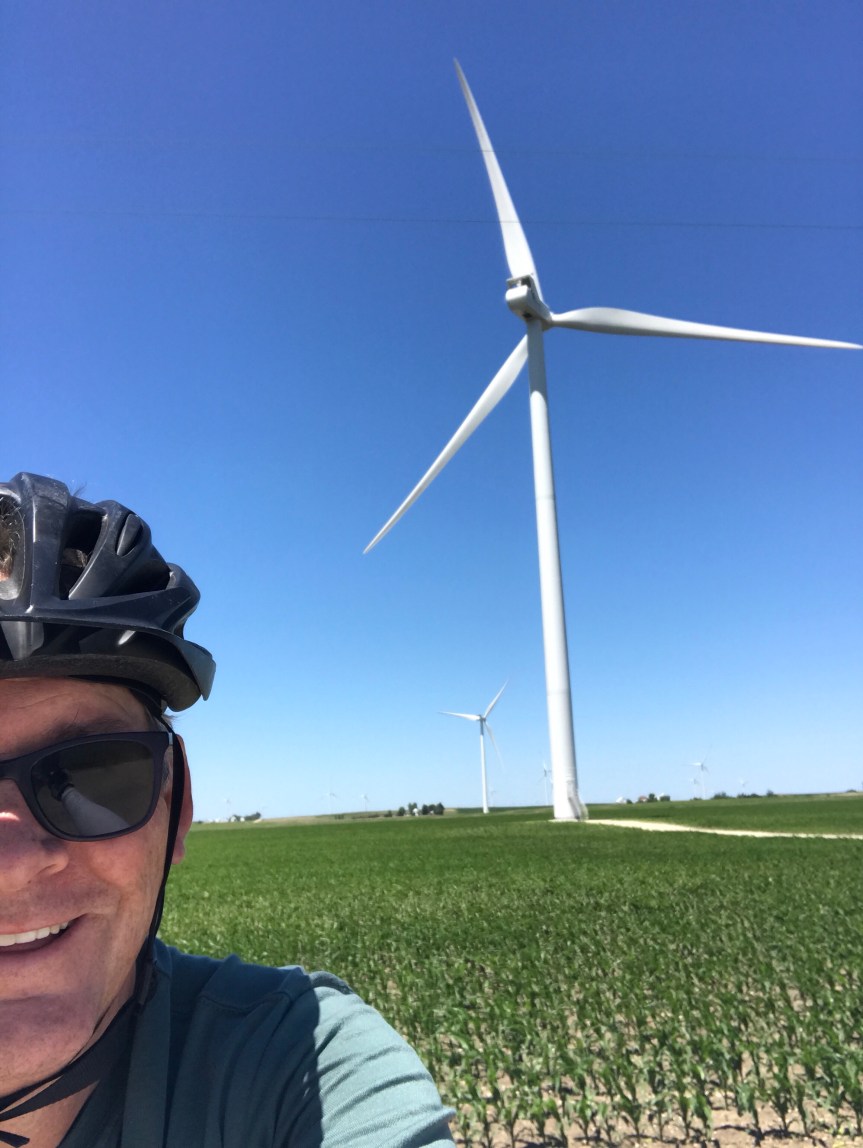
I once saw a turbine blade on display near the Energy Department. The thing looked to be as long as a football field. (How they drove into DC with it is beyond me.) Anyway, seeing these things from a distance is truly impressive but up close they are hypnotic. I nearly ran off the road I was so captivated by them.Another thing I noticed today is that the pool table is starting to have some gentle up slopes. I probably climbed 200 or 300 feet today, 30 feet here, 20 feet there. In Kempton I stopped for lunch at Tom’s. There is a mural that runs the length of the building. It’s a bit like to cover of Sgt. Pepper’s. I parked The Mule to the left of Dorothy from the Wizard of Oz. Is she signing something?
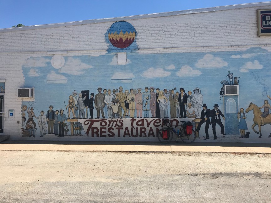
In Odell I crossed Route 66. There is now a bicycle route that follows the route from Chicago to Los Angeles. As I was taking a picture of the sign a woman jumped out of her car to get a picture of her own. My plan had me stopping at Cornell Illinois but there were no campgrounds or hotels there. There was plenty of daylight left and I was feeling fine after 67 miles so I continued on to the City of Wenona. They let bike tourists camp in the city park. It’s a very nice set up and the shower was the best. My thanks to the Wenona police officer who directed me to the park (and checked up on me later) and to Sheila who showed me around and gave me the secret code to the shower room.On days like this I have a hard time getting off the bike. I rode 92 miles. My total for the first two weeks of the tour is 1,030 miles.

May by the numbers

May was my first month in 2018 with over 1,000 miles. I rode 1,250 miles, 696 during the last 10 days on my bike tour. My longest ride was 79 miles from Hancock to Frostburg Maryland. I’m a bit surprised that I didn’t break 80 miles all month.

I rode in six states and DC.

For the year I’ve ridden 3,993.5 miles. Despite the tour, The Mule has less mileage (889) than either Little Nellie (973) or my Cross Check (1,850).

June’s gonna be a beast.

Any Road Tour – Day 1: who needs a canal anyway?

After a leisurely breakfast I packed my bike and nearly crippled it by getting the rear wheel all messed up with my cargo net. Ten minutes of cussing later, I base farewell to Mrs. Rootchopper and ride off to points north and west.

About five miles into the ride it occurred to me that I had failed to pack and important doodad, my Fiber Fix spoke. It’s a Kevlar cord that can replace a broken spoke, no tools required. So if I break a spoke I’m screwed. Yeah well….

I also forgot to pack a master link for my chain. This makes putting a broken chain together much easier. (Not that I’ve ever done it.)

I suppose I can stop at a bike shop and pick at least one of these items up.

The first 31 miles were a combination of my old bike commute and the old Vasa ride route to Potomac Maryland. A tailwind made the ride up the Mount Vernon Trail to DC a piece of cake.

I made my way along the river and under the Whitehurst Freeway. I passed a restaurant named Mate Sushi and thought of my Argentinian friend who is nuts about both mate and sushi. I carried on to the Capital Crescent Trail and ever so briefly on the C&O Canal towpath. As expected it was quite muddy. I thought about riding it but then decided to climb up to MacArthur Boulevard and use the roads.

I was dreading this short steep climb but it wasn’t so bad. My granny gear got its first of many uses today.

The rest of the ride to The kayakers put in near Old Anglers Inn was routine. I’ve done this ride scores of times.

I took a potty break. The restrooms have a covered sidewalk in front. When I came out, The Mule was dry as rain started to fall. Then skies opened up. I pulled out my bag of trail mix and munched a few handfuls. I can wait…..

The rain abated and I started the mile long climb to the top of Great Falls Park. Granny helped. The rains returned. My rain jacket and the physical effort were keeping me warm if not completely dry.

A left on River Road brought me to miles of big rolling hills. Big gear. Granny gear. Repeat.

I turned into Partnership Road and things got all kinds of farmy. Moo. Grain. Mud.

At Poolesville I stopped for lunch in the Watershed Cafe. I had a “veggie” sandwich (it had cheese in it) and some panther piss. ‘Twas yummy.

I asked the Google to plot a course for Frederick Maryland and so it did. The Google is good like that.

More farms and a few cute towns. I counted three purple houses. What’s up with that? Somehow the ride seemed downhill for miles and miles. And the route cleverly avoided Sugarloaf Mountain. My knees and back were pleased.

Now it was just a race against the rain. The skies grew darker as I rolled through funky Buckeystown.

Pedal, pedal.

I rode past English Muffin Road where Bimbo’s Bakery (I am not making this up) makes the nooks and crannies. I’d actually been to this area on a business trip a year or two ago.

I started seeking hotels but continued on playing chicken with the approaching storm. As raindrops started falling an Econolodge appeared.

As I rolled my bike into my room thunder roared from the dark clouds above. Timing is everything.

So I’m content with shelter, TV (I hope they have the Nats game), WiFi, and a Sheetz next door for fine dining.

68 miles down. 3,900 or so to go.

Any Road Tour: Last Days of Prep

Here’s what I did to get ready to hit the road:

  • Friday – Volunteered for Bike to Work Day in the rain
  • Saturday – Road to and from and during DC Bike Ride in the rain (45 miles). Watched 2 baseball games
  • Sunday – Road to Vienna VA to return Bike to Work Day materials (47 miles). Watched baseball game. Went to concert (Brandi Carlile) at The Anthem in DC.
  • Pulled together everything I’m bring on the tour. Put it in panniers and rode The Mule 1 mile to see if I distributed the weight properly. Mowed the lawn that had made use of a week of rain. Watched my last baseball game at home. (I’d love to go to the ballpark but there’s just no way.)


Image may contain: bicycle and outdoor

It weighs a ton. (I am bringing a second water bottle by the way.)

I also kept track of the problems with the C & O Canal towpath. Sort summary: mucho mas. Came up with a workaround to get me beyond the damage and the quagmire. Printed out some routing information that I will need. Did some last minute banking. Obsessively checked the weather forecast for tomorrow. (Rain. Thunderstorms. Typical DC area summer weather.)

So there you have it. Time to put up or shut up. Tomorrow I roll.


Any Road to the PNW – Pre-tour Anxiety

Construction, Fires, Floods, and Lions

I can’t sleep. All I can think about is the cascade of things that are going wrong with my bike tour and I haven’t even left home yet. From past experience I know that I have to go all mindful and concentrate on the here and now. This will be easier once I am rolling.

The route I am taking keeps changing and troubles keep arising. First I was worried about road construction on the route west from Missoula Montana. Next I discovered that the passes to the central Cascades in Oregon are compromised from last years wildfires. (Can’t wait for this years. Derp.) Then I found out that the route down the Columbia River gorge to Portland Oregon is partially closed because of more forest fires. This would force me to ride along the Washington State side of the river, missing Multnomah Falls in the process. For the last few days torrential rains have been wiping out the 185-mile C & O Canal towpath from near DC to near Williamsport, at Mile 100. Needless to day, the free camping sites are probably a mess too. This morning I learned that a mountain lion killed a mountain biker about 30 miles east of Seattle.

That’s right fires, floods, and lions. Whose idea was this anyway?

The Packing List

So I have busied myself making a packing list. Here’s what I am bringing.

Camping

  • Two-person tent
  • Lightweight sleeping bag
  • Silk sleeping bag liner
  • Pillow
  • Bear bag (for keeping carnivores away from my food)
  • Carbiner and nylon rope (to hang the bag)
  • Toilet paper
  • Utensils
  • Ear plugs
  • Sleep mask (for hostels)

Personal

  • Prescription sunglasses
  • Shaving cream
  • Razor
  • Toothbrush
  • Floss
  • Medicine
    • Maintenance inhalers (4) (Asthma)
    • Rescue inhalers (1) (Asthma)
    • Eye drops (glaucoma)
    • Aspirin (blood clots)
    • Ibuprofen
    • Nighttime Ibuprofen
  • Sunscreen
  • Ear plugs
  • Chamois cream
  • Back up prescription glasses
  • Book (maybe 2. Probably ancient Tom Wolfe paperbacks)
  • Passport (for going into Canada or boarding a flight if I lose my other ID)

Clothes

  • Bike shorts (3)
  • Technical bike shirts (3)
  • Cotton t-shirt
  • Off -bike shorts
  • Belt
  • Technical underwear for either on or off bike
  • Socks (3)
  • Bike shoes
  • 1 old t-shirt to use as a rag after it gets worn
  • Floppy hat
  • Teva sandals
  • Rain pants
  • Rain jacket
  • Sunsleeves

Electronics

  • iPhone
  • iPhone cable and charger
  • iPhone earphones
  • Small back up battery
  • Head light
  • Head light charger
  • Taillight belt
  • Taillight belt charger
  • Camera
  • Camera charging cable

Bike Gear

  • The Mule (1991 Specialized Sequoia touring bike)
  • Water bottles (2)
  • Extra water bottle in pannier
  • Four Ortlieb roll top panniers (2 small for the front, 2 large for the rear)
  • Ortlieb medium handlebar bad with map case
  • Bicycling gloves
  • Multitool
  • Tire levers
  • Tubes (3)
  • Folding spare tire
  • Valve adapter
  • Topeak RoadMorph Pump
  • Lube
  • Lock
  • Cables
  • Zip ties
  • Duct tape

Other

  • Adventure Cycling Association Maps (14)
  • Rudi’s route to Little Orleans (A cue sheet to circumvent most of the C&O Canal. A very hilly route that I hope not to use.)
  • Trail mix
  • Energy bars/fruit

The new stuff for this tour is underlined. As you can see I have already crossed out a few items. I wouldn’t know what to do with a cable if I had to do a roadside repair so there’s no point in bringing them. And other than the fact that I can take pictures while riding, the camera is kind of useless. I can use my iPhone for photos, and it will force me to stop to take the pictures which is not a bad thing.

The Route

Whether I like it or not, the route is changing as I type. My current thinking is that instead of riding the canal directly west from DC, I use roads to get me about 100 to 110 miles upriver. So on day one will be spent riding on the roads to Fredrick Maryland. I’ll stay in a hotel. This replaces my first C&O Canal day. Day two will involve riding roads west from Fredrick picking up the Canal and the Western Maryland Rail Trail either at Williamsport or beyond and overnighting in Hancock Maryland at mile 125. (The bike shop has a bunkhouse with showers and WiFi and such.) Day three will be 60 miles of mud to Cumberland assuming the the trail is open. If not, the pooch is screwed. But I’ll mix my metaphors and blow up that bridge when I get to it.

Today’s Fun

My anxiety woke me up at 5 a.m. I have to ride 45 miles round trip to Vienna Virginia to return Bike to Work Day materials. I had volunteered to staff a pit stop 1 1/2 miles from my house. What I didn’t know was that I was responsible for picking up and dropping off Bike to Work Day materials for the Fairfax Advocates for Better Bicycling (FABB), our suburban advocacy group, 23 miles away. This easy volunteering effort ballooned from a 3 hour commitment to about 12 hours. Suffice it to say, I’ll choose my volunteering events more carefully next time. On the plus side, I get to do a shake down ride on The Mule.

When I get home, I’ll watch the Nats game, do some laundry, and go a concert in DC. Hopefully, I can sleep in tomorrow.


Any Road or Fire and Rain

I chose Any Road to the PNW as the name of my bike tour but it’s beginning to look like I may have to change to Fire and Rain (hell, add Wind because the Great Plains are not exactly a light breeze).

Up until today, I have been focused on road closures in Idaho and Oregon. These closures are the result of fires from last summer. In the last several days, the mid-Atlantic has been hit with a rain event that will continue through the weekend. (Can’t wait to ride DC Bike Ride on Saturday!)

The rain is washing out sections of the C&O Canal towpath, the unpaved, flat route through the Appalachians. My friend Rudi has given me a workaround that will allow me to bypass more than one-half of the towpath. There will be some serious hills in the bargain.

There is no word about the western third of the towpath as well as the GAP trail from Cumberland to Pittsburgh.

Gee, I can’t wait to get started!

Any Road Indeed

There’s one week to go to lift off on my Any Road to the Pacific Northwest so I thought I’d check out some of the roads through the Cascades. I knew that a 50 mile section of Idaho State Highway 12 through the Lochsa River valley would be undergoing heavy construction. Now I have found out that a section of the road and trail along the Columbia River in Oregon, west of the Route 12 construction, will be closed outright. Last summer wildfires in this area damaged the trail and highway. I have two options.

Option One would be to stay on the Oregon side of the river and ride I-84 with its big rumble strips for tens of miles. Not fun, but there are plenty of services along the way.

Option Two is to cross over to the Washington side of the river. This road has much less traffic but services are “few and far between.” Basically, I’d have to carry food and water and lord knows where I’d sleep. The “few and far between” section is 83 miles long into “fierce headwinds.” We’re having fun now!

Another big drawback to Option Two is that I can cross back over to Oregon just east of Portland, but well west of Multnomah Falls. I really want to see the falls; it’s one of the must see places in the Pacific Northwest. FOMO lives.

Long story short, I have to stay flexible. When I get to Missoula I can talk to bike tourists and staff at Adventure Cycling for recommendations.