Well, once again I wasted untold hours posting this inane blog. In for a penny, in for a pound. So here goes with the pictures of 2019. With one, regrettably from a few years ago.


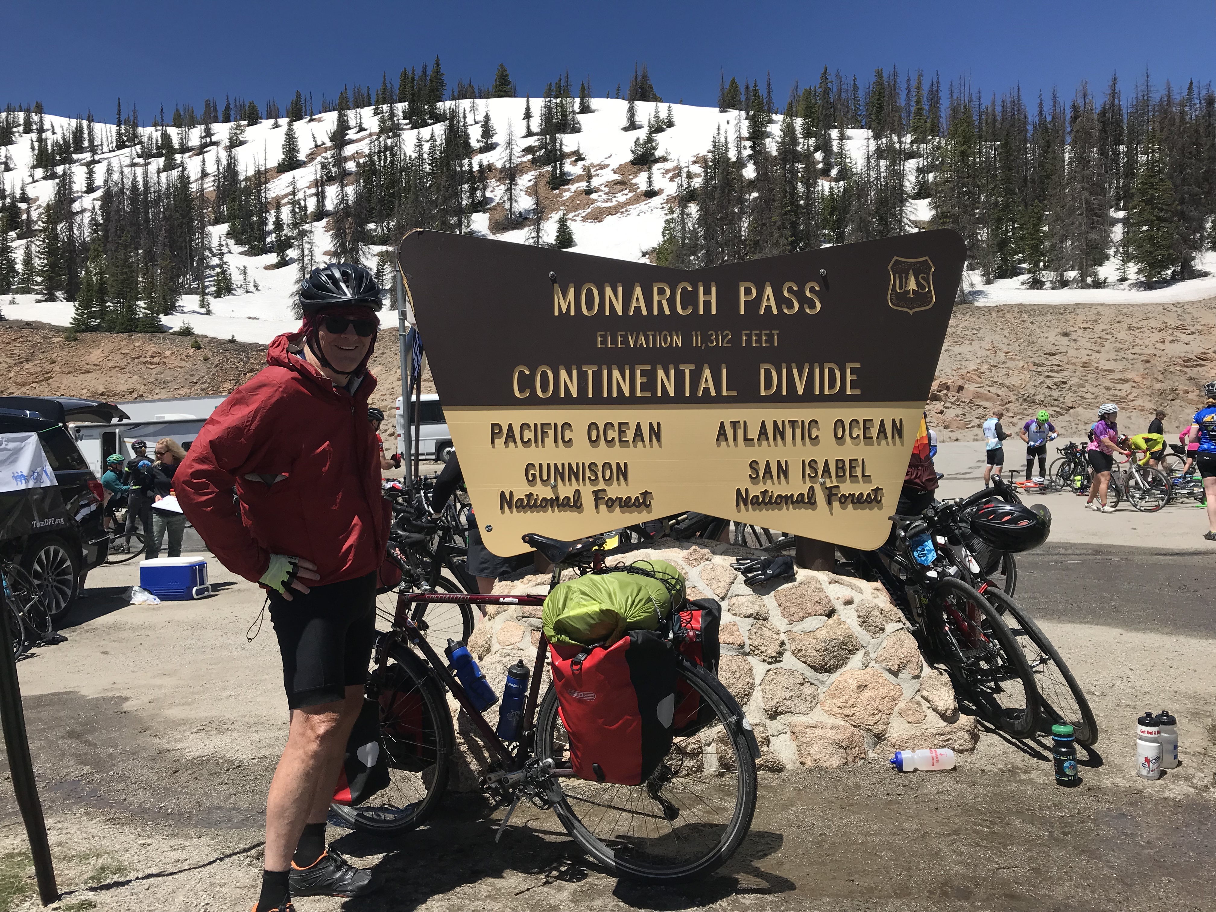


Well, once again I wasted untold hours posting this inane blog. In for a penny, in for a pound. So here goes with the pictures of 2019. With one, regrettably from a few years ago.
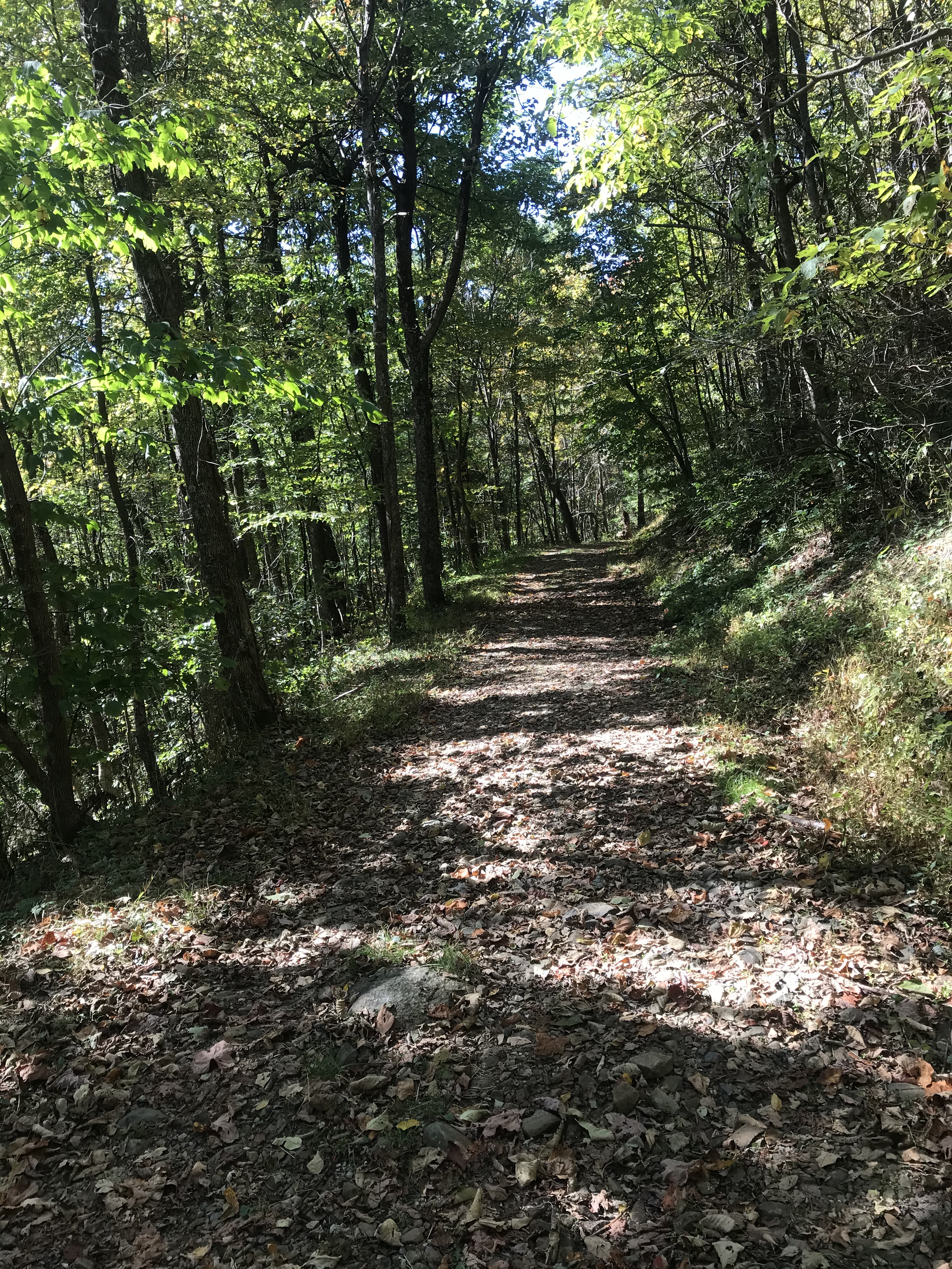
After 14 days of bike riding in a row, I decided it was time to take a day off. What better way than to do a hike in Shenandoah National Park.
My friend Chelli and her daughter signed up to climb 19,000+ foot Mount Kilimanjaro in Africa. To get in shape, Chelli assembled a team of grad school friends to do day hikes outside DC. Most of these hikes were done while I was on my bike tour but I joined the team when I came home.
We did two hikes on Sugarloaf Mountain in Maryland. After that, Chelli and her daughter went to Africa and conquered the big one.
Chelli called us together again for a Columbus Day hike. I chose Little Devils Stairs in Shenandoah National Park. According to the website HikingUpward.com this hike is rated at the same level of difficulty as the Sugarloaf hike.
I’d done Little Devils Stairs once before and remember it as challenging and fun. Somehow in the intervening years the trail became much steeper. I blame plate tectonics.
A full moon and fog on the river were indications of a beautiful fall day emerging on the way to Chelli’s house in Arlington. Chelli took the wheel of her car and we drove to the park, After about 40 miles the highway leaves the ugly urban area and enters splendid Virginia countryside.
Dry weather meant that the unpaved road to the parking lot made for easy driving. We parked and headed up the trail. Basically, this trail goes straight up a gorge along Keyser Run. The trail is rocky, increasingly so as we ascended. There were perhaps 8 creek crossings but these were trivial because the drought in this area reduced the creek to a trickle.
At one point in a particularly rocky section we lost sight of the trail blazes. No worries. We forged ahead and soon found the trail again. At a few points the hike became a rock scramble. I was huffing and puffing. We took some stops to gather ourselves. Then moved on and up.
The gorge was beautiful. The creek with a trickle of water, trees just beginning to take on their fall color, and sheer rock walls. I stopped a few times to appreciate how steep the trail was.

After the rock scrambles there were some switchbacks. An Hispanic family of about eight people came down the hill toward us. One of them was carrying an unopened bag of tortilla chips. Somehow I refrained from assaulting him with my hiking poles.
Soon thereafter we reached Fourway, the intersection of four hiking trails. We stopped to eat lunch which Chelli had packed. Veggie burgers, crackers, and watermelon.
We were burning up on the way up the 2.2 mile climb, but now that we were sitting the cool breeze across out sweaty clothing brought a chill. Time to boogie.
We took a fire trail all the way back down the mountain. 3.8 miles. I was wearing new hiking shoes that were a half size bigger than usual. The extra room in the toes kept my feet happy.
Along the way we passed an old graveyard. Several of the headstones indicated deaths in 1918. I speculated that the Spanish flu was the cause. Imagine being sick with that horrible disease up this mountain far from medical help.
As we left the graveyard the Hispanic family came hiking by. Hiking down that gorge must have been tough but they seemed like they were having a good time. Their ten-year old boy was running up the trail. Don’t you just hate youth?
Walking downhill for several miles can really deaden your legs. We managed without too much difficulty. My wonky left knee and hip did reasonably well. I felt a pain in the side of my hip most of the way down the hill but my knee tolerated the descent without much discomfort.
Normally, getting out of the car at the end of a hike makes me feel like I’m 90 but today I felt okay. New shoes, cortisone, and PT to the rescue.
Not a bad day off.
After two days of beautiful weather, The Mule insisted on going for a long ride. The Mule was jealous because I went hiking with friends yesterday. The Mule gets like that sometimes. The Mule would have killed me in my sleep if it had seen this view from the White Rocks overlook on Sugarloaf Mountain in Maryland.

And so I found myself heading northwest along the Potomac River. For 12 miles I rode into a headwind on the Mount Vernon Trail to DC. I crossed the river on the 14th Street Bridge and headed to Georgetown. Next, I took the Capital Crescent Trail along the north side of the river. I had a choice of routes. Either follow the C&O Canal towpath or switch to the somewhat hilly roads. I chose pavement since the towpath was a mess the last time I rode it.
After 30 miles I reached Potomac Village where gas costs more than top shelf single malt scotch.
I turned left onto River Road and partook of the massive rolling hills, views of stupefying mansions, the tony Bretton Woods Country Club, a Buddhist temple, a one-room schoolhouse, and fields of corn. After over 20 miles I had no choice but to climb Mt. Nebo Road. It goes up steeply, three times. Maybe four. However many times, the last one hurt.
I had a headwind leaving DC but now I could tell the wind direction had changed. I was riding effortlessly, except for the steepest hills. As every cyclist knows this either means you put performance enhancing drugs on your Wheaties or you have a tailwind. Since cinnamon isn’t a PDA, I knew it was the latter.
A few miles later I picked up the towpath, expecting there to be only one mile to get to Whites Ferry, where a privately run cable ferry shuttles travelers across the Potomac River. Somehow the one mile was actually four. Yeah, well. At least the towpath was in excellent condition. I spun along merrily and spooked a couple of deer who were hanging around looking for trouble. They put out their cigs and hightailed it into the woods.
I only had to wait five minutes for the ferry. There were a handful of cars on it coming and going so I was off the boat in under two minutes on the Virginia side of the river.

Did I mention that the weather was nice?

I rode to Leesburg and picked up some snackage. Then headed back home along 35 miles of the Washington and Old Dominion Trail. Into a headwind. Sadly, the snackage contained only chocolate and other sugary delights, not anabolic steroids.
I estimated that the ride would be about 100 miles, but my calculation error on the outbound portion of today’s excursion meant it would be a bit more.
All in all, it was a very pleasant day on the bike, except for the last 20 miles which I did on fumes while trying unsuccessfully to ignore a screaming left knee and shoulder. The left knee has been getting worse by the month and will require some medical intervention this fall. The shoulder has a rotator cuff impingement. (Impingement is a fancy medical term for “messed up”.) I could have surgery on it as well.
Did I mention my sore left hip?
Ugh.
This ride, my longest of the year, was well worth the pain.
 Yesterday brought the biggest one day haul ever.
While I was away, my friend Chelli decided to climb Mount Kilimanjaro this summer. To get in climbing shape she’d been taking Mrs. Rootchopper and other friends on hikes in the Catoctin Mountains and on Sugarloaf Mountain. Yesterday, a day that will live in humidity, I joined the fun as the gang returned to Sugarloaf.
Sugarloaf has been the scene of two of my past misadventures. Five years ago I hiked the yellow trail with a ninja and a golden retriever. The experience left me cripple for days, and oddly marked the beginning of the end of an eight-year friendship. Another time I rode bikes around the base of the mountain with Science Mom. She somehow managed to end up falling ungracefully into a mud puddle. Our friendship survived even with her temporary loss of face.
Getting back to yesterday, Chelli parked strategically below the peak of the mountain. We started hiking upward on the blue trail, transitioned to the purple trail, and returned to the blue trail. After forty seven miles, we stopped at the white rock overlook to munch on pita sammies that Chelli had prepared. Paul chipped (sorry) in some Nacho Cheese Doritos. It was a lovely view and even lovelier breeze.
Somehow the hike managed to seem all uphill. It took three hours and at least five gallons of sweat. Did I mention the humidity was off the charts?
A few years ago I did a hike in Shenandoah National Park with Kirstin. She used hiking poles and highly recommended them. On a whim, I bought a pair of poles on sale this spring. I have to say they are a big improvement over pole-less hiking. They kept me from turning my ankles and from putting excess impact stress on my knees and back. It only took about a mile for me to get used to them. When the hike was over, my wonky knee and hip didn’t have their usual crippling pain. I’d been wary of hiking in recent years but now I’m eager to get back out there.
I still can’t get over how hard hiking is. When I was younger I could run and jump and scramble and feel perfectly fine afterward. Yesterday, we were passed by a number of energetic young folk during the hike. I had to resist the urge to bludgeon them with my poles.
It turns out that hiking is deceptively hard work, made all the harder by aging. And it’s probably good for you. All the same, I’m glad Chelli is hiking Mt Kilimanjaro and not me.
After taking the first day of the month off, I managed to mash 204 miles in six days, ending with yesterday’s 63 miles of cold, hilly Vasanneuring. So I decided to take a rest day today.
By 11 a.m. I was going stir crazy so I jumped into the car and drove to Great Falls Park in Maryland for a recovery hike. As soon as I got out of the car, I could tell this was not going to be restful.
I took off up the canal towpath to the far end of the River Trail. This hike is about 2 miles round trip and totally flat. Just the thing for my tired knees and back. Along the way I did the runners calf stretch against a tree or two. This somehow loosens my back up.
Next I walked to the Olmstead Island Overlook located right in the middle of the river at the fall line. The Potomac was raging today in Mather Gorge. The sound of the rushing water was a tonic.
Once back to the canal, I decided to give a longer, hillier walk a go. I took off up the Gold Mine Spur Trail. I was intending to hike the Gold Mine Loop Trail but when I got to a fork in the road I Yogi-ed it.
My turn to the right took me back toward the canal. At one spot I had a nice high view of the gorge. I made my way back down to the canal via the Lock 19 spur trail. By the time I arrived at the car, I felt like the Tin Man in need of a joint lube.


I had walked over five miles. It was time to head home. Of course, this meant that I had to drive by the gym. Why not stop to lift some weights? So I did.
I feel all rested now.
Or not.
The low 40F Degree temperatures and the cooling breeze and clouds did not exactly call to my bikey brain today. Off I drove (yes, I have a car) to the gym to push and pull on the machines. The machines won.
Then it was off to Great Falls National Park in Maryland. I pulled into the Carderock area that is located about 2 miles outside the Beltway. The access road passes beneath the C&O Canal and towpath. After parking and getting myself all arranged with layers and hat and Buff and backpack full of water bottles, I set off the Billy Goat C trail, clockwise toward the river. I was walking upriver and the breeze was in my face. It took about a half mile to warm up. My legs had bounce in them and I was cruising along, resisting the urge to break into a trot. Slow. Down.
There were no leaves on the trees, so the place looked rather stark. I had good views of the river and they didn’t disappoint. After about a mile, the path looped back to the towpath. I headed further upriver on the towpath.
The canal in some sections has water. I noticed some tall reeds near my side of the waterway. Inside the grass was a great blue heron shopping for lunch. A few hundred yards later I could hear the quacking of a duck. The duck was with about sever others, paddling about near the far side of the canal. I saw something move in the tall grass on the canal’s far bank. It was a fox, stalking the ducks. No worries. They kept themselves out of paw’s reach.
The sky was full of bird’s chirping. A massive flock of birds filled the trees beyond the canal. Suddenly, they became quiet and flew of in a cloud of winged mayhem. Seconds later they landed in some trees no more than a hundred yards from where they started. The racket began anew. Birdbrains.
I kept walking past the sign for the Billy Goat B trail. I was taking the canal to the western entrance so I could loop back along the river. Like the C trail and the towpath, the B trail was practically deserted. I was also fortunate that it was dry. The towpath, which is flat and has poor drainage, had some muddy sections.
Back along the river, wind at my back, I cruised along. My legs were still fresh but my decrepit lower back was not on board for the fun. Fortunately, I came upon some big rocks on the river’s edge. I sat down and pulled out a water bottle. The water was rushing over some rocks about 50 yards into the river. Once my breath calmed, I listened.
Is there anything more relaxing than the sound of rushing water?
I listened.
The cool breeze tried to distract me. It failed.
I listened.
After perhaps 15 minutes, I decided to get up before I fell asleep. If it had been 10 degrees warmer, I’d be curled up in a ball snoring.
It took a few minutes to get myself back into an ambulatory mood. Rock scrambles, none too difficult for an old dude with balance issues, persuaded me to get with the program.
I made it across a small stream. Most people would dance across on the rocks but my body seems to prefer stumbling.
Soon I was turning back to the towpath up two quick rises. With the wind at my back, I hiked the towpath beyond where I had parked my car to pick up the C trail. The trail took me back to the river and eventually, to the car.
My legs felt fine. My lower back was bitching up a storm. I didn’t care. My head felt great.
So my first hike, a six-miler, of the new year was over. A productive use to a cold and gray afternoon.


For a year that started out rather boring, 2017 did a fine job of recovering. In no particular order, here’s my top ten.

The weather was perfect. I haven’t gone for a day hike in months so I grabbed a print out for Ashby Hollow – Mt. Weathers from a backpack I use for hiking and took off.
I had this weird feeling of deja vu. For good reason. This was my first solo hike on the Appalachian Trail a few years ago.
The drive up a dirt road to the start was an adventure. The road was all ruts and washboard. The car’s autotraction was going nuts. My wheels were spinning but I made it in one piece.
I immediately recognized the start. Oh well, no sense in going looking for another trail. Off I went down the rock trail.
I remember this hike as very difficult footing. And it was but not nearly as bad as others I have done since. The low humidity and comfortable temperatures combined with persistent shade to make this just a glorious day to be in the woods.
Once I warmed up, I could just truck along. Unfortunately I had to look mostly at the trail because of all the rocks and tree roots. While doing this it’s really hard to think about anything but the task at hand which ends up being kind of meditative.
This section of the AT is called the roller coaster. On weekends it’s crowded but today I only saw four hikers in three hours, two of them passed me withing 200 yards of the finish. This time of year there aren’t much in the way of flowers so I basked in the green. There were no vistas on this hike at this time of year. The foliage is just too dense. No worries.
Despite having hiked this before, I missed two turns. I haven’t seen a blaze in a while, have I? Nope. When you wander off, just return to the trail and begin again. Sounds like a Joseph Goldstein meditation video.
It took me about 3 hours to do the entire 6 1/2 miles.
The ride back took me past vineyards and horse farms and through tony Virginia towns like Upperville and Middleburg. With windows down and the sun shining through puffy clouds it was a lovely end to another day of slacking.


I feel like I am riding the last couple of days of a bike tour. The end is just down the road a bit. I want to savor the last bits of riding but the anticipation of completion is yanking at my monkey mind.
That’s what the last week of work before retirement is like. It would feel worse if not for the fact that DC is a sauna this week and I am mighty happy for the air conditioning in my office.
Today, I erased all the scribblings on my office white board. The list of hikes I meant to do this year. (Intentions count, don’t they Ultrarunnergirl?) And the list of 17 states I have ridden a bike in. And the list of 31 countries that various members of the family Rootchopper have visited. (The family Rootchopper sounds a bit like we should be escaping the Nazis over the Alps. Given the recent news, it might not be a bad idea.) Down went the list of clever phrases I came across during my six years while at this job, such as
So tomorrow is closing time. Every new beginning comes from some other beginning’s end.
Time to get to know the feeling of liberation and release.
One life, some bicycles. A million possibilities, zero clue!
Information and news from David Goodrich, author of A Hole in the Wind.
Coast-to-coast US bike tour
Exploring Nevada's backroads by bicycle
Just another manifestation of my obsession with riding
Around Eire on Frida, Bike Friday
Follow my Journey!
just a girl on a mission to pet every puppy in the world. #stillatourist
Two travelers on two tires
The Weston Front - the destination of a road less travelled...
One step, then one step more
Riding the South Coast of Massachusetts and Rhode Island
Welcome To My Adventures
