An Accidental Return to Ashby Hollow

The weather was perfect. I haven’t gone for a day hike in months so I grabbed a print out for Ashby Hollow – Mt. Weathers from a backpack I use for hiking and took off.

I had this weird feeling of deja vu. For good reason. This was my first solo hike on the Appalachian Trail a few years ago.

The drive up a dirt road to the start was an adventure. The road was all ruts and washboard. The car’s autotraction was going nuts. My wheels were spinning but I made it in one piece.

I immediately recognized the start. Oh well, no sense in going looking for another trail. Off I went down the rock trail.

I remember this hike as very difficult footing. And it was but not nearly as bad as others I have done since. The low humidity and comfortable temperatures combined with persistent shade to make this just a glorious day to be in the woods.

Once I warmed up, I could just truck along. Unfortunately I had to look mostly at the trail because of all the rocks and tree roots. While doing this it’s really hard to think about anything but the task at hand which ends up being kind of meditative.

This section of the AT is called the roller coaster. On weekends it’s crowded but today I only saw four hikers in three hours, two of them passed me withing 200 yards of the finish. This time of year there aren’t much in the way of flowers so I basked in the green. There were no vistas on this hike at this time of year. The foliage is just too dense. No worries.

Despite having hiked this before, I missed two turns. I haven’t seen a blaze in a while, have I? Nope. When you wander off, just return to the trail and begin again. Sounds like a Joseph Goldstein meditation video.

It took me about 3 hours to do the entire 6 1/2 miles.

The ride back took me past vineyards and horse farms and through tony Virginia towns like Upperville and Middleburg. With windows down and the sun shining through puffy clouds it was a lovely end to another day of slacking.


Hiking Up and Down to Raven Rocks

Today I did another out and back hike on the Appalachian Trail. At my current pace I should have the entire AT hiked by 2047.

I started at just to the west of Snickersville Gap, where VA Route 7 crests the Blue Ridge. I lucked out and got the next to last parking space in the trailside lot.

This area of the AT is known as the roller coaster because it goes up and down and up and down and around. The hike started with up to the ridge. The entire hike is heavily wooded. And rocky. And tree rooty.

IMG_0825

The start is up. And Up. Then down to a run, which in Virginia is a creek. The water level wasn’t too high so I made it across with ease. A family came a hiking behind me. They were a chatty bunch. I resigned myself to the fact that solitude would be elusive.

Next I hiked up to the ridge Then down with rocky switchbacks. Then up. Then down to a creek. Then up then down. Then up until I saw sky.

Ultrarunnergirl told me a few years ago that seeing sky is good. It was. The trail emerged from the woods to a rocky area, the top of a cliff. This is Raven Rocks. Chatty family were sitting across the part of the cliff top that had the best views.

I resisted the urge to push them over the edge and hike a bit further. There was another pretty decent spot to enjoy the view. A sole hiker was just beginning to get underway. She said “It’s a pretty nice spot. You can have it.” And off she went down the trail.

I took in the view for a few minutes. It was very viewy. There was gIMG_0833reen. And a pleasant breeze. I got down on my stomach and looked over the edge. I couldn’t see the bottom. I saw a lot of tree tops. I thought of Flogini who used to climb cliffs even higher than this. I can’t even….

I turned to go down. And the chatty bunch asked me to take their picture at the top of the cliff. Okay folks, step back. Once more. Ayyyyy!

I was nice and took pictures of them from multiple vantage points. The gods will reward me someday.

Not today though. On the hike back to the car, I caught my right toe on a rock and started to fall. I put my arm around a small tree in the middle of the trail. My momentum swung me around the tree so hard that I came out of my left shoe. I swung completely around the tree and landed on my butt between two big sharp chunks of granite. The bark of the tree took some skin off my left arm. And somewhere in the spin I cut two fingers on my right hand. There was blood.

IMG_0832

Feeling like a complete spaz, I put my shoe back on and dusted off my pride and hiked onward. A group of 20 somethings came by with music playing. Bad country music. I resisted the urge to hoedown.

Along the way coming and going I encountered plenty of backpackers and some other families. This is apparently a pretty popular place for a day hike.

For good reason.

It lasted only about 4 hours, quite a bit less than I expected. On the way home, I bought a cherry pie at a place in Round Hill. It’s a bit of a cheat. People thought that the pies were made on site, but the Washington Post did an article about the place and exposed the pies as factory made by Sara Lee. They’re still damned good and a suitable replacement for a shower beer.

IMG_0837

There are a few more pictures in an album on my Flickr page.

Keys Gap to Buzzard Rocks Overlook on the Appalachian Trail

Last night I pondered my Sunday choices: bike ride, bike ride to a Nationals baseball game, or hike. I decided on a hike guessing that there might be some rain during the game.

Last weekend I hiked from Keys Gap to Loudon Heights, heading north on the Appalachian Trail. This weekend I headed south toward Buzzard Rocks overloook. which held the hope of a view of the Shenandoah Valley.

The weather report was for temperatures in the 60Fs. And no rain. Well, there was rain but it mostly happened before I started making for a muddy track. There was a bit of rain in the middle of the hike but the tree canopy protected me.

I tried to avoid the mud but it was pointless. So I let the little boy in me out and I made my peace with the slop.

The trail here is much less rocky than the trail just to the north. Without the mud you could cover this trail lickety split.

There was quite a lot of traffic during my first 2 1/2 miles. Boy scouts. Groups of adults. They all looked like they had camped overnight. They didn’t seem strained by their packs so I assumed (correctly) that the terrain would be forgiving.

The only steep section had rock steps, easy to negotiate. And it was rather striking to look at.

Along the way I was treated to my favorite: ferns. I tried to plant ferns in my side yard. They all died within weeks. Ferns are best left to the woods.

As the trail rose to the ridge, I walked into the clouds. This was great for atmospherics but the ruined the view from the overlook.  I did get one picture where you can vaguely make out the Shenandoah Valley.

The hike was 7.7 miles and that’s a comfortable distance for me. I didn’t feel all banged up like last weekend.

I was surprised to learn that it was raining heavily in DC. Sometimes you guess right. The Nats game started 90 minutes late.  Works for me.

There are some more pix on my Flickr page.


Hiking to Loudon Heights

It was finally, finally time to get out of the city and into the woods. I’d been biking and baseballing and graduating and concerting for weeks and my brain needed a long solo hike in the woods.

Harpers Ferry, West Virginia sits at the confluence of the Potomac and Shenandoah Rivers. Alas, the Shenandoah gives it up and from here to the Chesapeake Bay the river is known as the Potomac. Just southeast of Harpers Ferry the Potomac passes through mountains. On the northern side of the river there are two overlooks. I hiked 19 miles in one day to check them out. Today I explored the overlook on the southern side of the river on a ridge known as Loudon Heights. I got the idea for this hike from a fellow blogger who did a shorter, steeper version of this hike in January 2016. Her hike began in Harpers Ferry, crossed the Shenandoah and climbed up to the ridge about 1 1/2 miles from the overlook.

It was my intent to do this same hike but then I found another hike that was longer and more gradual. This hike begins at Keys Pass 5 1/2 miles to the south of the overlook. It follows the Appalachian Trail for about 4 miles along the ridge line then switches to the Loudon Heights Trail to get to the overlook.

The skies were overcast. Temperatures were in high 50Fs when I set out. There was so much green. The path was somewhat muddy. Then it became rocky. Then smooth. Then rockier. Then smooth. Then ludicrously rocky. Then not so much. Did I mention that it was rocky.

The AT is rocky. How anybody with a full pack gets through the Virginia portion of the trail without breaking an ankle is beyond me. I am a tenderfoot. Literally. I hate rocky trails. I came to a kind of truce with this one out of necessity. There are so many rocks that you have to look down nearly the entire time you are hiking. You lose track of time. I couldn’t believe that 90 minutes had passed since the start. Focusing on the rocks is meditative, annoyingly so. It had a rather interesting benefit for me. I noticed that my tenderfootedness was caused by me tensing my feet up as I walked among the rocks. Walking on them instead and focusing on keeping my feet relaxed made for much easier walking. I didn’t exactly end the hike with happy feet but I managed to enjoy what would otherwise have been a miserable experience.

Since I was spending so much time looking down, I had to consciously stop and take in the scenery. Most of the hike is through a forest on a ridge line. And I looked up at the through the canopy to the clouds above. Ahh.

Being at the top of things also meant that many old trees succumbed to winds. The trail is obstructed by a few dozen downed giants. They are easy enough to get past though.

For the first 3 1/2 miles I didn’t see or hear a single person. Not one. For the next 2 miles I did encounter a few people here and there but, thankfully, none of them were loud.

Getting to the overlook actually involves hiking down from the ridge. When I got there I had it all to myself for about 3 minutes. I was all set to just park my butt on a rock for a half hour. Then another hiker showed up. Yeah, well….

After taking some pictures of Harpers Ferry (the view of town is much better from Maryland Heights, by the way) I started back. Good thing I left. More and more people were heading my way. I group of young men came by. The last of them was actually talking business. I resisted the urge to dope slap him.

When I got back on the AT, I started encountering serious backpackers heading north. These dudes were in tip top hiking shape. A solo hiker and I stopped to chat. He was a large human, 6 foot 4 or so and easily 250 pounds. He was hiking 20 miles or so today on his way to Harpers Ferry.  His pack looked hefty. He was all smiles. Nice guy.

The last three miles were a bit of a slog. I really need to learn to ease into these things; 11 miles was a bit much. I stopped to stretch my hamstrings from time to time. The last half mile was mercifully light on rocks and was nearly flat. I needed that.

Unlike most hikes I’ve done, I had very good cell service on this one so I instagrammed my ass off. I posted all the pictures on my Flickr page.

Pictures of the Year 2016


cropped-img_0149.jpg
Sunrise on the Mount Vernon Trail

When the sun and my work day cooperate, I stop and take in the sunset over the Potomac River. It rarely disappoints.

The Big Reveal
100,000 Miles

It took me 25 years but I managed to ride 100,000 miles since acquiring The Mule (bottom left) in 1991. In 2002 I bought Big Nellie, a Tour Easy recumbent (top left), and rode it exclusively for several years. In 2009 (or thereabouts) I bought my Bike Friday New World Tourist, a folding travel bike that I call Little Nellie (upper right). Last year I picked up Deets, a Surly Cross Check, that turns out to be a fantastic bike for commuting.

img_0283
Drink Up Cowboy (Colonoscopy Prep)

In October, amid a frenzy of bike event riding, I had a colonoscopy. It was my third. I am happy to report that there was no cancer detected. I’ll be back in 2019 for another. Drink up!

27127466460_c4196ab26e_m
Me in Front of Copenhagen Central Station Bike Racks

I went to Scandinavia with my wife and daughter. I didn’t ride a bike but I saw a few here and there. The cycling infrastructure is so much better than in the U.S. And the road users are all so well behaved. As my friend Finn Quinn once said: “The future is a foreign country.” We can only hope.

26552436583_5da8aef4b0_m
Beer Tent Volunteers at Tour de Fat

I volunteered at the Tour de Fat this year. I had fun despite not being completely recovered from my not so fun trip to the ER a week earlier. We were a well behaved bunch. The only beer we imbibed were the ones the organizers comped us for our efforts on their behalf.

26025108405_b7d0607a56_m
Friday Coffee Club

You may never find a more wretched hive of scum and villainy. You certainly won’t find it here because the building where this picture was taken is being renovated. Friday Coffee Club moved across town and, but for one appearance after Thanksgiving, I had to stop going. I miss these scoundrels.

25124970033_bdd5088f21_m
Michelle Smiles Even When She’s Freezing (Vasa Ride)

Speaking of scoundrels, for the last several years Michelle has been running bike events at the Washington Area Bicyclists Association (WABA). I am convinced that she is trying to kill me. It is widely rumored that she even controls the weather. I am so grateful for all the hard work Michelle (and the other folks at WABA and the volunteers) put in to make #bikedc better every year. (Michelle also has a serious interest in the Beats and Kerouac. Check out her blog.)

dscn5676
Amy at Great Pumpkin Ride

It was windy and coolish, but Amy was determined to do her first long event ride. This hill during the Great Pumpkin Ride near Warreton Virginia was mighty steep but Amy (with Jody behind her) managed it without apparent difficulty. The leaves on the road were produced by powerful winds that made the day quite a work out. The rest stop after this photo was at a Old Bust Head brewery.

wp-image-430941086jpg.jpeg
Sleeping Bear Dunes in Michigan

This picture doesn’t do justice to how steep these dunes are. And this is only about 1/2 of the height. The remaining elevation is obscured by the angle of my shot. Later that day the road I was on went up the dunes just to the south of this one. It made for some tough climbing into a persistent headwind. It was perhaps the physically hardest day of my 11-day solo bike tour. As hard as it was on my body, the tour was a feast of rolling meditation for my mind and soul.

img_20160707_125941.jpg
What Yoopers Eat (Bike Tour)

The people who live on the Upper Peninsula of Michigan, the UP, are called Yoopers. They eat white fish and pasties (a kind of meat pie) and have their own candy bar. They (mostly) also talk like all the hockey players from Ontario that I roomed with during my freshman year at college. Eh?

27081573716_f8e80fc524_m
My Deck Buddy

I was hanging out on my deck one sunny day when I went to open my deck umbrella and found this critter. Cute.

26021255403_10305b1772_m - Copy
My Perch in Left Field

The left field grandstand was my perch for about 10 games at Nats Park this year. I became personal friends with Jason Werth. (That’s him in left field.) Okay, that’a s lie.Somewhere up there under the third light stanchion is Klarence keeping score. Hurry spring!

DSCN4804_1218
Darth Paul on the Five Boro Ride

That’s Paul on the left on FDR Drive on the east side of Manhattan. It is cold. It is raining. Paul is not smiling. He had so much fun. We stopped in Astoria, Queens, to stand around and freeze our asses off. Who knew that the Brooklyn Queens Expressway would be even more fun. I have now ridden my bike across the Verrazano Narrows and the Golden Gate. Woot!

IMG_0122
A Section of the AT

The Appalachian Trail is nice enough to come down to I-66 which made for a couple of convenient solo day hikes.

27906192426_f8ab97e3e5_m
Veronica Help Us Save a Duckling on the MVT

I found a duckling on the Mount Vernon Trail on the way to work one morning. Mr friend Linel stopped to help and we tried to figure out what do with it. Then Veronica showed up. She took the duckling to her office then to an animal rescue place. This is a decidedly better outcome that the two animal skeletons I saw last year. Just sayin’. Thanks, Veronica.

IMG_0031
Night in the ER

This is me getting a nebulizer treatment in the ER. A few hours earlier I couldn’t move without experiencing a knife-like pain in my upper right chest. (I blame yoga.) The doctors were pretty confident that it wasn’t a heart attack. I had a resting pulse of 46 and my blood pressure was normal. They did some tests and took some x-rays. Then they put this on me. I was recovered enough to do Bike to Work Day, volunteer at Tour de Fat, ride DC Bike Ride, and fly to Stockholm over the next nine days. Do not try this at home. Or anywhere else, for that matter.

Dumbo in Trumbo Hollow

Reading on the deck just wasn’t happening this morning. It was beautiful out. You know, puffy white clouds, gentle breezes, low humidity. So I decided to go for a hike.

I chose Trumbo Hollow because I was getting started late and wanted to make sure I could find a place to park my car.

The highways were all but deserted and there was ample parking. So an hour after I left home I was on the Appalachian Trail heading south.

IMG_0122.JPG
Think you can find the AT?

After a half mile of gently flat trail, I started up. And up. Switchback after switchback. Rocky footing. Eventually the hill and rocks  gave way to a grassy meadow. This was a first for me. Mostly woods lead to more woods. After the meadow came a downhill to a street. Then across the street and uphill again. You’d think they’d designed these trails so that they don’t go up and down and up and down. Just for me because I am the only important person in the universe.

IMG_0130.JPG
Rocks
IMG_0123.JPG
Meadow

There were quite a few other people hiking today. This included a group of about 14 hikers who were getting their social fix where introverts like me go to get away from people like them. I am grateful that they were heading in the opposite direction.

There were some couples here and there out on a date hike. It’s apparently like a bike date except you leave the bikes at home. You know you’re getting somewhere with your date when she tells you to bring a tent. Hike dates are not at all subtle that way.

The hike took me a little over 3 miles to a shelter that served as a landmark for the turnaround. One of the date couples I saw earlier had passed me and were hanging out there. She was on the phone. In my book she is not tentworthy.

I turned around and headed back. About a mile later, on a mostly smooth part of the trail and a rock reached up and tripped me. I swear it moved. I went down HARD on my forearm. Thankfully I landed on a rock-free part of the trail. My forearm just missed landing across a basketball size rock. This would have been ugly. Snap. Scream. Blood. Pain.

But it wasn’t. A stabbing pain went up my arm into my shoulder nonetheless. Ow. F-word. This HURTS. I stayed down for a minute as the pain subsided and came to realize that I didn’t break or dislocate anything. In all the arm fun, I missed the part about my left knee whacking the ground. It was bloody and aching. Both my palms hurt too. Suffice it to say a bruised knee and two bruised palms is a less than idea condition to ride 100 miles with. So tomorrow’s century ride will be interesting indeed.

IMG_0127
Albino caterpillars have been known to trip hikers

I dusted myself off. Poured water over the bleeding bits and continued on. But for the limp and the icky blood I was having a pretty good time. About a mile from my car a through-hiker came barreling toward me, aided by his adept use of two hiking poles. These hikers are in phenomenal shape. He had earbuds in. This kind of ruined my mental picture of through-hikers, but maybe he could hook up with phone girl at the shelter.

I made it back to the car in one piece but my knee was stiffening up. After stopping for some nutritious food (an M&M cookie ice cream sandwich counts, doesn’t it?…Oh, shut up. Don’t judge. I had a boo boo.),  I drove home. After a shower and some real food (involving a bagel, cheese, and a tomato) I came out on the deck and made good use of some frozen veggies. And a beer.

IMG_0132


Manassas Gap: A Short Hike on the AT

The floor refinishing job in our house is done. All that is left is the move back into the rooms which will happen on Thursday. In the meantime we are staying off the floors as much as possible. They look great but the air in the house is a tad stinky. (Not nearly as bad as I expected.) So getting out of the house was the plan.

I decided to use the perfect spring weather for a hike. I drove to Linden Virginia to do a solo 2 1/2 mile out-and-back hike on the Appalachian Trail. Last year I did a similar hike a few miles to the north at Ashby’s Hollow. It was pretty tough. That section of the AT is called the roller coaster for good reason.

This hike started 100 yards from I-66 and went up. And up. And up. Most of the climbing was done through as series of switchbacks. For the first half mile, I could hear the traffic on the interstate. Once I put the mountain between me and the highway I was good to go.

I stopped to take pictures as I went. Not because I was seeing anything particularly spectacular but to put space between me and two women who were hiking together. I followed a spur to check out an overlook. It was pretty but I’ve seen the view 100 times before from the highway below.

The trees are just starting to leaf. This allowed me to see a long way through the dense forest down the side of the mountain I was climbing. When I was little, I broke a rule about staying near home and went for a hike in the woods that began a mile away.  It seemed like I was walking forever. It was really only about a mile. There was a thick carpet of pine needles and the pine trees muffled sounds of the nearby roads and suburbs. For some reason, this hike called to mind that one.

The AT is very easy to follow. This section of the trail is well maintained (by volunteers, I might add). I had passed the two hikers before the spur. When I came back to the AT, they were a few hundred yards ahead. I fiddled with picture taking allowing them to get out of sight.

I wanted some space from people and things. My wife and I have been confined to two rooms that are crammed with furniture for the rest of the house. This and a week in the office including attending a retirement reception for our old boss, made my introverted self feel very much trapped.

I was alone. And Asian man, perhaps 50 years old, came bounding down the trail in my direction. He had a big smile on his face. Then I was alone again. Slogging up the hill. I’d smile too if I were coming down.

Then I head footsteps behind me. Within minutes a bearded hiker with a backpack came past. He was moving at a steady clip, much faster than me. We said our hellos and he was gone.

At times the trail flattened out and my pace picked up. This was not a race. I spent most of my attention on the rocky path in front of me. If you look away while walking you’ll trip for sure. So you have to focus on the task at hand. If that isn’t meditative I don’t know what is.

Eventually I came to a shelter built for AT hikers. A middle aged man, his teenaged soon, and the hiker who blew by me were talking. The hiker had begun his trek at the start in Georgia. He was nearly halfway to Maine. The boy aspired to hike the AT with his father. They were doing their first recon of the trail on the date that the boy had set back in December. (This is one determined kid.)  The hiker told us some tales. He wasn’t hiking for some great spiritual experience. He just like to hike and had the time and the money. Why not. He seemed like a totally normal bloke out for a 2,200 mile stroll in the woods.

25859091954_aae299f766_m

After about 30 minutes I headed back down to the car. The going was much easier. No wonder the Asian man was smiling. I passed another northbound through hiker. I told him about the shelter and the through hiker I had met. “He’s my partner.”  No wonder he wasn’t lonely.

We went our separate ways. Two more Asian hikers came through. Maybe this was a coincidence. I had read that in Japan walking in the woods is held in high regard. Perhaps it was a cultural thing. Japanese researchers find hiking to be good medicine for the stress of urban life.

Another half mile and I came upon what looked like a husband and wife. They smiled but didn’t say anything. They were wearing ear buds. I cannot for the life of me understand why you’d wear earbuds in the woods.

After about two miles of downhill trudging, my lower back (which I had pulled a few days ago) was starting to rebel. To ease the strain, I broke into a trot. Of course, this made my knees angry. To take my mind off the discomfort, I looked through the trees down the mountain, trying to pick out the trail as it switched back and forth.

Back at the car, I ran into a man who was about to head up the trail for an overnight hike. He had no information so I told him about the shelter at 2 1/2 miles. Maybe someday he’ll just keep on going all the way to Maine.

The pix I took are over on my Flickr page.

I was thinking of driving to Philadelphia tomorrow to watch the Nationals play. I’ve never seen a game there. I tweeted the idea and none of my tweeps seemed he least bit interested in joining me. So I guess I’ll do a long ride somewhere. The Cross Check is itchin’ to get out.


A Year in the Woods

This was my second year of doing day hikes. Early in the year I made a list of hikes that I wanted to do on my white board at work. I modified the list, adding three hikes that friends of mine did during the year and taking off two hikes, Bull Run Mountain and Sky Meadows, because they are in an area that is infested with ticks. (One of my coworkers contracted Lyme disease at Sky Meadows.)

Hike List 2015

As you can see I cross off quite a few hikes.

To get the year off on the right foot, I went up to Great Falls Park in Maryland and did the Billy Goat B and C trails. I had done this last summer and enjoyed the route but not the heat. This is about a six mile hike, mostly flat.  It was a good way to start the year.

For the next several months I forgot about hiking. I don’t honestly know why. When I realized that I had missed some of the year’s best hiking weather I kicked it into gear on the first weekend in June and re-visited Rock Creek Park. This time I did the Valley and West Ridge trails in a counter clockwise direction. It’s a good hike, about 10 miles or so.

It was time to get away from the city. The next weekend I found a hike online that seemed to offer some solitude. It was an out and back hike on the section of the Appalachian Trail in Virginia known as Ashby Hollow. The trail was rocky and the the ups and downs lived up to the nickname Roller Coaster. I was amazed that through hikers did this section of the trail carrying big backpacks. I saw a couple too.  More power to you folks.

I was on a roll. A luck would have it Ultrarunnergirl was looking to go for a hike in the Shenandoah National Park. We headed out to White Oak Cannon. Here, she advised me to buy a year pass to the National Park system. Great idea. We hiked up the canyon, enjoying waterfalls all the way up.  At the top of the trail we took a fire road up to Skyline Drive. At her suggestion, we hiked up the steep trail to Little Hawksbill, the highest point in the park. Hiking down beat the crap out of my legs. To get back to the start we took the Cedar Run Trail. This was a pretty trail but it was also rocky and the rocks were slippery. Ultrunnergirl’s iPhone went for a swim. She went for a rock slide near the end of the hike. This was my first non-solo hike since college. It was also my first hike in Shenandoah National Park. If you live in the mid-Atlantic and do not take advantage of this park you are really missing out.

A couple of weeks later, I headed back to the park for a hike up Little Devil Stairs.  This was pretty challenging and involved crossing and re-crossing a stream. Well worth the early wake up on a day off from work.

I took the rest of July off.

I started August with a hike on the exotically names Potomac Heritage Trail. It was not the best hike but it was close to home. Then, in mid-August, on my 60th birthday, I did the most popular hike in these parts, Old Rag. It was quite challenging. I was a bit annoyed by the rock scramble. At one point I had to wedge myself into a gap between two boulders and hike vertically, with my back against one boulder and my feet on the other. Not my style at all. The view from the summit was pretty darn nice. If you want solitude, find another hike.

In September we took a long vacation in Australia, New Zealand and Thailand. We did a whole mess of walking including an easy short hike at  Kata Tjuta in the outback.

Kata Tjuta Walk


After returning home, I made my way back to Great Falls Park in Maryland for an easy hike along the River and Gold Mine Loop trails.  I’d done each of these before but separately.

The next week, I drove to Prince William Forest Park down near Quantico. The trails here are not very well marked so I was a bit confused as to where I was or where I was going. Nevertheless, I cobbled together a pretty successful loop hike.

My last hike (unless I get really motivated in December) combined two hikes near Harper’s Ferry. Maryland Heights and Weverton Cliff offer fantastic overlooks of the Potomac River, Harper’s Ferry and the Shenandoah River.  This was my longest hike by far. Probably about 3 miles longer than I was comfortable doing.

I am learning what I like and don’t like about hiking. I am not a big fan of rocks. I don’t like rock scrambles. Nor do I like rocky trails. I am not a big fan of fording streams either. I am afraid that I am going to turn an ankle, fall, or get soaked. Since most of my hikes are solo, any one of these would be bad news.

So that’s how I put my best foot forward this year. I hope next year that I do more hiking with friends. So if you live in DC and wanna go for a trek in the woods, I’m all ears.

Two Hikes near Harper’s Ferry

A friend of mine used to hold health retreats near Harper’s Ferry. If the weather was good, she’d take her guests for a hike. I honestly don’t know where she took them but when I started hiking I search for hikes near Harper’s Ferry. There are two hikes that are very popular. They each include an overlook with spectacular views of the Harper’s Ferry area.

I began at the Harper’s Ferry train station. My year pass for all national parks allowed me to avoid the $10 parking fee. Thanks again, Ultrarunnergirl.

Off I hoofed across the railroad bridge from Harper’s Ferry to the C&O Canal towpath, all the while looking at Maryland Heights across the way. I am going up there?  I headed northwest along the path for a half mile, crossed the empty canal, and a two-lane road and the climbing began on the Maryland Heights hike.

Up, up, up. This trail is relentlessly up. And steep in some sections. I was breathing pretty heavily until my lungs caught up with my legs. I took a side path to what I thought was the overlook but it was just an old battery. The Heights were strategically important in the Civil War. There are batteries and a fort along the trail.

Up some more. The trail began to narrow and become rockier. I hate rocks in a trail but that’s what most of the trails in this area are like.

#hike #Marylandheights #harpersferry overlook

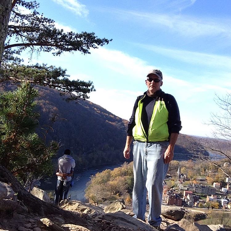
I crested the hill and now found myself winding back down to the overlook. More rocks. The leaves on the ground made footing slippery. Soon I was at the overlook. Well worth the effort, especially on this beautiful fall day. A young couple was canoodling so I decided to take a couple of pictures and head back up to the main trail. On the way up I must have passed 20 people coming down. So much for canoodling in peace.

Back on the main trail I took a right to climb to a ridge line. It was really steep and rocky but I just kept at it. Soon I arrived at an old stone fort. I would have hate to have had to build this thing. There’s no structure to the fort, just stone walls.

During my hike I twice was passed by a group of ultramarathon runners. Essentially these people are speed hikers. How they managed to move so fast without turning an ankle is beyond me. They were apparently doing and out and back run because I saw them again about 30 minutes later.

I headed back down on a mercifully smoother trail paralleling the ridge. Judging from the number of people coming up, this must be one of the most popular trails in the area. I was grateful to have arrived before the crowds.

Back on the towpath I headed south east for about 3 miles. The views of the river were magnificent and the sound of the water rushing over the rocks was incredibly calming.

I was now on the Weverton Cliff hike. This also the Appalachian Trail. I ate my apple and watched a parade of 20 fully loaded hikers coming my way as I walked to the steep trail to the cliff. This sucker is tough going. I would not want to do it with a full backpack. The backpackers that I saw were pretty scruffy but they moved with deliberate speed. Not fast, exactly, but they were relentless and focused.

Across the railroad tracks, up a side trail, under a highway, up some more trail, across a street and the real fun began.

Up into a seemingly endless series of switchbacks. The bigger trees had all dropped their leaves but the undergrowth was bright yellow and orange in the slanting fall sunlight. It’s good to have pretty when you are suffering.

On the Maryland Heights descent I fell when the leaves gave way under my feet. I just landed on my butt and slid. As I climbed up to the cliff and woman did the same thing right in front of me. She just laughed it off.

Switchback after switchback then finally a sign pointing the AT to the north and the overlook to the south.

I had to hike down a few extremely hundred yards to the overlook but the view was really excellent. The sun had come out and I basked in its warmth for a few minutes as I watched the sunlight glittering over the Potomac River.

View from #wevertoncliffs #hike #harpersferry

I dreaded the hike down but found it to be surprisingly easy. I passed a woman who looked to be well into her seventies. I sure hope I am that fit when I am her age.

I made it back to the towpath in good shape and headed for Harper’s Ferry. At this point I was wishing I had brought more than one apple. I was hoping I wasn’t going to hit the wall. I started following a guy with a backpack on. He didn’t seem to be putting any effort into his stride but I still could not keep up with him.

So I looked at the sunlit yellow leaves, watched a bunch of vultures soaring next to the rock face of Maryland Heights and enjoyed the final two miles as much as my tired body would allow.

If I were to come back to Harper’s Ferry I think I’d park at the base of Weverton Cliff, hike up to the overlook turnoff and take the AT north. Despite all the rocks, it was a pretty damned nice hike. Maryland Heights was just as hard but the crowds would put me off a return.

My Flickr page has all the pix I took.